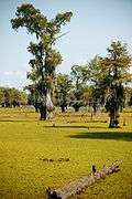
Lake Bistineau State Park
Lake Bistineau State Park, one of twenty-two state parks in Louisiana, is located on Lake Bistineau, a long and narrow waterway formed in 1800 as a result of extensive flooding created by a large log jam on the nearby Red River. The principal source of Bistineau is Dorcheat Bayou, which originates in southwestern Arkansas and flows through Nevada and Columbia counties before reaching Webster Parish, where it empties into the lake near the village of Doyline. Loggy Bayou, meanwhile, links Bistineau with the Red River.
History
In 1938, then Governor Richard W. Leche signed legislation establishing the state park.[3] Lake Bistineau has remained a popular North Louisiana recreational site, particularly for fishing and boating, for more than a half-century. In 1942, a large dam and spillway were completed at the southern end of the lake in an effort to maintain a constant water level. Additional land was acquired thereafter, and the park was expanded in 1948.[4]
Activities
Accommodations at Bistineau are moderately priced.Seven deluxe cabins, with one suited for the disabled, rent for $120 per night and can sleep up to eight persons. Group Camp I rents for $500 per night and includes a dining hall, kitchen, and twenty cabins which can sleep up to 160 people. Group Camp II rents for $250 per night and includes a dining hall, kitchen, and six cabin, which can sleep a maximum of forty-eight persons. The park offers forty-four improved campsites with water and electrical hookups which rent for $22 per night. Another seventeen premium sites with water and hookups rent for $28 per night. There are two swimming pools open during summer.[1]
Gallery
| Lake Bistineau State Park |
|---|
| Cypress trees and Spanish moss line much of the lake. |
| Parts of the lake were drained in 2008 to remove green moss that covered the lake. |
| Cypress roots can be seen from the view of the drained lake. |
| The original level of the lake can be seen by looking at the cypress roots. |
| The green moss is considered a pest and was removed to prevent overpopulation. |
| The drained lake provided scenic walkways for exploration. |
| Green moss can still be seen on the low water levels at this area. |
|
References
External links
|
|---|
|
| Federal | |
|---|
|
| State | | |
|---|
| | |
|---|
| State Preservation Area | |
|---|
| State Forests | |
|---|
| State Wildlife Refuges |
- Elmer's Island
- Marsh Island
- Rockefeller
- St. Tammany
- State
- Terrebonne Barrier Islands
- White Lake Wetlands
|
|---|
| Wildlife management areas |
- Acadiana Conservation Corridor
- Atchafalaya Delta
- Attakapas
- Barataria Preserve
- Bayou Macon
- Bayou Pierre
- Ben's Creek
- Big Colewa Bayou
- Big Lake
- Biloxi
- Bodcau
- Boeuf
- Bonnet Carré Spillway
- Buckhorn
- Camp Beauregard
- Catahoula Lake
- Clear Creek
- Dewey Wills
- Elbow Slough
- Elm Hall
- Floy Ward McElroy
- Fort Polk
- Grassy Lake
- Hutchinson Creek
- Indian Bayou
- Jackson Bienville
- Joyce
- Lake Boeuf
- Lake Ramsey Savannah
- Little River
- Loggy Bayou
- Manchac
- Marsh Bayou
- Maurepas Swamp
- Old River Control
- Ouachita
- Pass A Loutre
- Pearl River
- Peason Ridge
- Pointe-aux-Chenes
- Pomme de Terre
- Red River
- Russell Sage
- Sabine Island
- Sabine
- Salvador/Timken
- Sandy Hollow
- Sherburne
- Sicily Island Hills
- Soda Lake
- Spring Bayou
- Tangipahoa Parish School Board
- Thistlethwaite
- Three Rivers
- Tunica Hills
- Union
- Walnut Hill
- West Bay
|
|---|
|
|---|
|
| Other | |
|---|
|
|


