Lake Wisconsin
| Lake Wisconsin | |
|---|---|
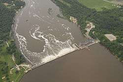
 Aerial view of the Prairie du Sac Dam, which impounds Lake Wisconsin, taken during the June 2008 flood. | |
| Location | Columbia / Sauk counties, Wisconsin, United States |
| Coordinates | 43°18′36″N 89°43′29″W / 43.31000°N 89.72472°WCoordinates: 43°18′36″N 89°43′29″W / 43.31000°N 89.72472°W |
| Lake type | reservoir |
| Primary inflows | Wisconsin River |
| Primary outflows | Wisconsin River |
| Basin countries | United States |
| Surface area | 9,500 acres (3,800 ha) |
| Max. depth | 40 ft (12 m) |
| Surface elevation | about 774 ft (236 m) |
Lake Wisconsin is a reservoir on the Wisconsin River in southern Wisconsin in the United States. It is located in Columbia and Sauk counties, approximately 5 mi (8 km) southeast of Baraboo and 25 mi (40 km) NNW of Madison. Today it is home to the Wisconsin wine appellation of the Lake Wisconsin AVA.[1]
It was formed by the construction of a dam at Prairie du Sac, which was begun in 1911 and completed in 1914. It is part of the Wisconsin River system of reservoirs. The lake has a maximum depth of 40 ft (12 m). It has a shoreline of 57 mi (90 km) and an area of 9500 acres (38 km²).
Its construction effectively ended the Fox-Wisconsin Waterway connection to the Mississippi River, although commercial traffic had ended decades before completion of the dam.
The lake provides flood control and is a popular destination for recreational boating and fishing.
The Merrimac Ferry crosses the lake at Merrimac, Wisconsin.