Larling
| Larling | |
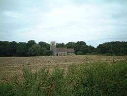
 Saint Ethelbert Parish Church, Larling |
|
 Larling |
|
| Population | 278 (parish, 2001 census) |
|---|---|
| OS grid reference | TL9889 |
| – London | 94 miles (151 km) |
| Civil parish | Roudham & Larling CP |
| District | Breckland |
| Shire county | Norfolk |
| Region | East |
| Country | England |
| Sovereign state | United Kingdom |
| Post town | NORWICH |
| Postcode district | NR16 |
| Dialling code | 01953 |
| Police | Norfolk |
| Fire | Norfolk |
| Ambulance | East of England |
| EU Parliament | East of England |
Coordinates: 52°28′10″N 0°55′01″E / 52.4695°N 0.916897°E
Larling is a village and part of the civil parish of Roudham and Larling (where the population is included), in the English county of Norfolk.[1] The village is 8.5 miles east north east of Thetford, 21.4 miles west south west of Norwich and 94 miles north east of London.[2] The nearest railway station is at Thetford for the Breckland Line which runs between Cambridge and Norwich. The nearest airport is Norwich International Airport. The village is situated a little north of the A11 Trunk road.
History
Larling has an entry in the Domesday Book of 1085.[3] In the great book Larling is recorded by the name ‘’Lur(i)inga’’. The main landholder is William de Warenne with the main tenant being Hugh. The survey also mentions a mill.
The Parish Church of Saint Ethelbert
The church is built of flint and dates from the 14th century, with stone used only for dressings. The tower is in the 15th-century Perpendicular style. On the north side there is a staircase turret that leads to the belfry. The windows date from the 15th century also. There is an ornamented Norman doorway, with one of the pillars carrying a mass dial. Inside the church is a four-sided font from the 12th century.[4]
Shrubb Family, Shrubb cottage, Larling
Shrubb family is one of the longest running communities in England. Founded in 1970 in a 17th-century cottage near the old A11 and the Angel pub, the membership and fortunes of the community have fluctuated over the years, but the ethos of low impact living and environmental harmony have persisted.[5]
Shrubb is listed on the Diggers and Dreamers online directory and there is a video of the early days at Shrubb on YouTube titled 'Shrubb Family 1973 part 1 & 2'. Shrubb is featured in "Communes in Britain" by Andrew Rigby, 1974.
References
- ↑ OS Explorer Map 236 - King’s Lynn, Downham Market & Swaffham. ISBN 978-0-319-46408-3.
- ↑ County A to Z Atlas, Street & Road maps Norfolk, ISBN 978-1-84348-614-5
- ↑ The Domesday Book, Englands Heritage, Then and Now, Editor: Thomas Hinde,Norfolk page 191, Larling, ISBN 1-85833-440-3
- ↑ The King’s England series, NORFOLK, by Arthur Mee,Pub:Hodder and Stoughton,1972, page 154 Larling, ISBN 0-340-15061-0
- ↑ Diggers and dreamers : the 1990/91 guide to communal living, edited by Vera Ansell et al.,. Dunford Bridge, Sheffield, [England]: Communes Network. 1989. ISBN 978-0-9514945-0-9.
|first1=missing|last1=in Authors list (help)
External links
| Wikimedia Commons has media related to Larling. |