Lime Springs, Iowa
| Lime Springs, Iowa | |
|---|---|
| City | |
 | |
 Location of Lime Springs, Iowa | |
| Coordinates: 43°26′58″N 92°16′52″W / 43.44944°N 92.28111°WCoordinates: 43°26′58″N 92°16′52″W / 43.44944°N 92.28111°W | |
| Country | United States |
| State | Iowa |
| County | Howard |
| Area[1] | |
| • Total | 1.02 sq mi (2.64 km2) |
| • Land | 1.02 sq mi (2.64 km2) |
| • Water | 0 sq mi (0 km2) |
| Elevation | 1,240 ft (378 m) |
| Population (2010)[2] | |
| • Total | 505 |
| • Estimate (2012[3]) | 501 |
| • Density | 495.1/sq mi (191.2/km2) |
| Time zone | Central (CST) (UTC-6) |
| • Summer (DST) | CDT (UTC-5) |
| ZIP code | 52155 |
| Area code(s) | 563 |
| FIPS code | 19-45165 |
| GNIS feature ID | 0458350 |

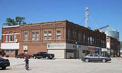
Lime Springs is a city in Howard County, Iowa, United States. The population was 505 at the 2010 census.
History
The Old Town of Lime Spring was platted in 1857.[4] After the railroad was built into the area, the town relocated nearby to its tracks. The town, then called Lime Spring Station, was platted again in 1867.[5]
Geography
Lime Springs is located at 43°26′58″N 92°16′52″W / 43.44944°N 92.28111°W (43.449578, -92.281226).[6]
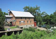
The town center originally existed a little farther to the north around the Lidtke Mill on the Upper Iowa River, but moved south when the railroad came to town.
According to the United States Census Bureau, the city has a total area of 1.02 square miles (2.64 km2), all of it land.[1]
Climate
| Climate data for Lime Springs, Iowa | |||||||||||||
|---|---|---|---|---|---|---|---|---|---|---|---|---|---|
| Month | Jan | Feb | Mar | Apr | May | Jun | Jul | Aug | Sep | Oct | Nov | Dec | Year |
| Record high °F (°C) | 59 (15) |
63 (17) |
83 (28) |
91 (33) |
93 (34) |
100 (38) |
102 (39) |
101 (38) |
98 (37) |
92 (33) |
75 (24) |
62 (17) |
102 (39) |
| Average high °F (°C) | 23 (−5) |
28 (−2) |
41 (5) |
57 (14) |
69 (21) |
78 (26) |
82 (28) |
80 (27) |
72 (22) |
59 (15) |
42 (6) |
27 (−3) |
54.8 (12.8) |
| Daily mean °F (°C) | 14 (−10) |
19 (−7) |
31 (−1) |
45 (7) |
57 (14) |
67 (19) |
71 (22) |
69 (21) |
60 (16) |
47 (8) |
33 (1) |
19 (−7) |
44.3 (6.9) |
| Average low °F (°C) | 5 (−15) |
9 (−13) |
21 (−6) |
33 (1) |
44 (7) |
55 (13) |
59 (15) |
57 (14) |
47 (8) |
35 (2) |
23 (−5) |
10 (−12) |
33.2 (0.8) |
| Record low °F (°C) | −35 (−37) |
−36 (−38) |
−29 (−34) |
−1 (−18) |
21 (−6) |
34 (1) |
40 (4) |
34 (1) |
24 (−4) |
10 (−12) |
−16 (−27) |
−30 (−34) |
−36 (−38) |
| Average precipitation inches (mm) | 1.0 (25) |
1.0 (25) |
1.9 (48) |
3.5 (89) |
4.1 (104) |
5.2 (132) |
4.5 (114) |
5.3 (135) |
3.8 (97) |
2.5 (64) |
2.1 (53) |
1.4 (36) |
36.3 (922) |
| Source: weather.com[7] | |||||||||||||
Demographics
| Historical populations | ||
|---|---|---|
| Year | Pop. | ±% |
| 1880 | 470 | — |
| 1890 | 550 | +17.0% |
| 1900 | 605 | +10.0% |
| 1910 | 498 | −17.7% |
| 1920 | 595 | +19.5% |
| 1930 | 539 | −9.4% |
| 1940 | 567 | +5.2% |
| 1950 | 551 | −2.8% |
| 1960 | 581 | +5.4% |
| 1970 | 497 | −14.5% |
| 1980 | 476 | −4.2% |
| 1990 | 438 | −8.0% |
| 2000 | 496 | +13.2% |
| 2010 | 505 | +1.8% |
| 2014 | 492 | −2.6% |
| 2015 | 490 | −0.4% |
| Source:"American FactFinder". United States Census Bureau. and Iowa Data Center Source: | ||
2010 census
As of the census[2] of 2010, there were 505 people, 238 households, and 143 families residing in the city. The population density was 495.1 inhabitants per square mile (191.2/km2). There were 253 housing units at an average density of 248.0 per square mile (95.8/km2). The racial makeup of the city was 99.4% White, 0.2% Native American, and 0.4% Asian. Hispanic or Latino of any race were 0.4% of the population.
There were 238 households of which 26.5% had children under the age of 18 living with them, 47.5% were married couples living together, 9.2% had a female householder with no husband present, 3.4% had a male householder with no wife present, and 39.9% were non-families. 35.3% of all households were made up of individuals and 18.1% had someone living alone who was 65 years of age or older. The average household size was 2.12 and the average family size was 2.77.
The median age in the city was 45.4 years. 23.4% of residents were under the age of 18; 4.8% were between the ages of 18 and 24; 21.2% were from 25 to 44; 27.9% were from 45 to 64; and 22.6% were 65 years of age or older. The gender makeup of the city was 49.5% male and 50.5% female.
2000 census
As of the census[9] of 2000, there were 496 people, 220 households, and 144 families residing in the city. The population density was 487.8 people per square mile (187.8/km²). There were 243 housing units at an average density of 239.0 per square mile (92.0/km²). The racial makeup of the city was 98.39% White, 0.40% Native American, 0.60% Asian, and 0.60% from two or more races. Hispanic or Latino of any race were 1.01% of the population.
There were 220 households out of which 29.1% had children under the age of 18 living with them, 53.6% were married couples living together, 10.9% had a female householder with no husband present, and 34.1% were non-families. 31.4% of all households were made up of individuals and 16.4% had someone living alone who was 65 years of age or older. The average household size was 2.25 and the average family size was 2.81.
In the city the population was spread out with 25.2% under the age of 18, 5.6% from 18 to 24, 26.4% from 25 to 44, 17.3% from 45 to 64, and 25.4% who were 65 years of age or older. The median age was 41 years. For every 100 females there were 87.2 males. For every 100 females age 18 and over, there were 91.2 males.
The median income for a household in the city was $33,750, and the median income for a family was $39,063. Males had a median income of $30,000 versus $21,776 for females. The per capita income for the city was $15,706. About 5.2% of families and 5.9% of the population were below the poverty line, including 5.5% of those under age 18 and 6.8% of those age 65 or over.
Arts and culture
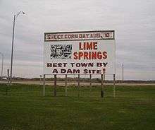
Sweet Corn Days is the festival of the year in Lime Springs, held on the second Sunday in August. The day features free sweet corn and a parade. Other events are held on Saturday.
The historic Lidtke Mill converted into a museum is a popular attraction.
References
- 1 2 "US Gazetteer files 2010". United States Census Bureau. Retrieved 2012-05-11.
- 1 2 "American FactFinder". United States Census Bureau. Retrieved 2012-05-11.
- ↑ "Population Estimates". United States Census Bureau. Retrieved 2013-05-23.
- ↑ Fairbairn, Robert Herd (1919). History of Chickasaw and Howard Counties, Iowa, Volume 1. S. J. Clarke Publishing Company. p. 399.
- ↑ Fairbairn, Robert Herd (1919). History of Chickasaw and Howard Counties, Iowa, Volume 1. S. J. Clarke Publishing Company. p. 424.
- ↑ "US Gazetteer files: 2010, 2000, and 1990". United States Census Bureau. 2011-02-12. Retrieved 2011-04-23.
- ↑ "Monthly Averages for Lime Springs, Iowa". The Weather Channel. Retrieved 29 November 2016.
- ↑ "Census of Population and Housing". Census.gov. Retrieved June 4, 2015.
- ↑ "American FactFinder". United States Census Bureau. Retrieved 2008-01-31.
External links
| Wikimedia Commons has media related to Lime Springs, Iowa. |
- The Lime Springs Herald
- Lime Springs Community Club's unofficial city site.
- The Lime Springs Page
- City-Data Comprehensive Statistical Data and more about Lime Springs
