List of Kochi Metro stations
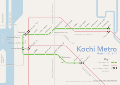
This is a list of the planned stations of the Kochi Metro. There are 22 stations planned on the line from Aluva to Pettah.[1][2]

Kochi Metro - Phase 1 Route Map
Proposed Kochi Metro Route Map | |||||||||||||||||||||||||||||||||||||||||||||||||||||||||||||||||||||||||||||||||||||||||||||||||||||||||||||||||||||||||||||||||||||||||||||||||||||||||||||
|---|---|---|---|---|---|---|---|---|---|---|---|---|---|---|---|---|---|---|---|---|---|---|---|---|---|---|---|---|---|---|---|---|---|---|---|---|---|---|---|---|---|---|---|---|---|---|---|---|---|---|---|---|---|---|---|---|---|---|---|---|---|---|---|---|---|---|---|---|---|---|---|---|---|---|---|---|---|---|---|---|---|---|---|---|---|---|---|---|---|---|---|---|---|---|---|---|---|---|---|---|---|---|---|---|---|---|---|---|---|---|---|---|---|---|---|---|---|---|---|---|---|---|---|---|---|---|---|---|---|---|---|---|---|---|---|---|---|---|---|---|---|---|---|---|---|---|---|---|---|---|---|---|---|---|---|---|---|
| |||||||||||||||||||||||||||||||||||||||||||||||||||||||||||||||||||||||||||||||||||||||||||||||||||||||||||||||||||||||||||||||||||||||||||||||||||||||||||||
| Sl No | Station Name | Height of Rail Level | Platform Type | Alignment Description | Location |
|---|---|---|---|---|---|
| 1 | Aluva | 12.5 m | Side Platform | On 1000 m curve | |
| 2 | Pulinchodu | 12.5 m | Side Platform | Curved | |
| 3 | Companypady | 12.5 m | Side Platform | Straight | |
| 4 | Ambattukavu | 12.5 m | Side Platform | Straight | |
| 5 | Muttom | 12.5 m | Side Platform & Island Platform | Straight Curved | |
| 6 | Apollo Tyre | 12.5 m | Side Platform | Straight | |
| 7 | Jacobite Church | 12.5 m | Side Platform | Curved | |
| 8 | Kalamassery | 12.5 m | Side Platform | Straight | |
| 9 | Pathadi Palam | 12.5 m | Side Platform | Straight | |
| 10 | Edapally Junction | 12.5 m | Side Platform | Straight | 10°1′35.96″N 76°18′33.33″E / 10.0266556°N 76.3092583°E |
| 11 | Changampuzha Park | 12.5 m | Side Platform | Straight | 10°0′54.64″N 76°18′8.26″E / 10.0151778°N 76.3022944°E |
| 12 | Palarivattom | 12.5 m | Side Platform | Straight | 10°0′32.27″N 76°18′13.86″E / 10.0089639°N 76.3038500°E |
| 13 | Nehru Stadium | 12.5 m | Side Platform | Straight | 10°0′1.86″N 76°17′56.41″E / 10.0005167°N 76.2990028°E |
| 14 | Kaloor | 12.5 m | Side Platform | Straight | 9°59′40.62″N 76°17′29.77″E / 9.9946167°N 76.2916028°E |
| 15 | Town Hall | 12.5 m | Side Platform | Straight | - |
| 16 | Madhava Pharmacy | 12.5 m | Side Platform | Straight | 9°59′2.64″N 76°16′55.38″E / 9.9840667°N 76.2820500°E |
| 17 | Maharaja College | 12.5 m | Side Platform | Straight | 9°58′24.34″N 76°17′05.96″E / 9.9734278°N 76.2849889°E |
| 18 | Ernakulam Junction | 12.5 m | Side Platform | Straight | 9°58′3.92″N 76°17′28.60″E / 9.9677556°N 76.2912778°E |
| 19 | GCDA | 12.5 m | Side Platform | Straight | 9°57′59.72″N 76°17′53.73″E / 9.9665889°N 76.2982583°E |
| 20 | Elamkulam | 12.5 m | Side Platform | Straight | Opposite to a cross road –Janatha road – which is leading to commercial establishments and residential areas |
| 21 | Vyttila Mobility Hub | 12.5 m | Side Platform | Straight | |
| 22 | Thaikoodam | 12.5 m | Side Platform | Straight | |
| 23 | Petta | 12.5 m | Side Platform | Straight | |
| 24 | Alliance Junction | 12.5 m | Side Platform | Straight | |
| 25 | SN Junction | 12.5 m | Side Platform | Straight | |
| 26 | Tripunithura | 12.5 m | Side Platform | Straight |
See also
References
This article is issued from Wikipedia - version of the 6/7/2016. The text is available under the Creative Commons Attribution/Share Alike but additional terms may apply for the media files.