| Name |
Address |
Municipality |
PC |
Coordinates |
IDF |
IDP |
IDM |
 |
Image |
|---|
| Discovery Claim (Claim 37903) National Historic Site |
Claim No. 37903 |
Bonanza Creek |
Y0B |
63°55′00″N 139°19′01″W / 63.9168°N 139.317°W / 63.9168; -139.317 (Discovery Claim (Claim 37903) National Historic Site) |
6310 |
|
|
|

More images |
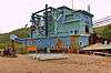
| Dredge No. 4 National Historic Site |
Lot 586, group 1052 |
Bonanza Creek |
|
63°56′38″N 139°20′10″W / 63.9439°N 139.336°W / 63.9439; -139.336 (Dredge No. 4 National Historic Site) |
6280 |
|
|
|
More images |
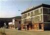
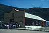
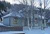
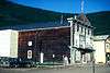
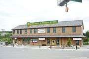
| Caribou Hotel |
Dawson Charlie Street |
Carcross |
Y0B |
60°09′55″N 134°42′22″W / 60.1652°N 134.706°W / 60.1652; -134.706 (Caribou Hotel) |
|
9834 |
|
|
More images |
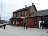
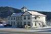
| White Pass and Yukon Railway Station |
Main Street |
Carcross |
Y0B |
60°09′54″N 134°42′18″W / 60.165°N 134.705°W / 60.165; -134.705 (White Pass and Yukon Railway Station) |
6723 |
|
|
|
More images |
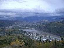
| St. Paul's Anglican Church National Historic Site |
|
Dawson City |
Y0B |
64°03′33″N 139°26′20″W / 64.0591°N 139.439°W / 64.0591; -139.439 (St. Paul's Anglican Church (Dawson City, Yukon)St. Paul's Anglican Church National Historic Site) |
14122 |
|
|
|
.JPG)
More images |
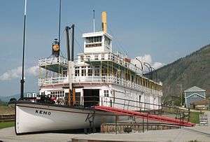
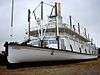
| S.S. Keno National Historic Site |
|
Dawson City |
|
64°03′45″N 139°26′10″W / 64.0625°N 139.436°W / 64.0625; -139.436 (S.S. Keno National Historic Site) |
9308 |
|
|
|
More images |
| Lowe's Mortuary |
|
Dawson City |
|
64°03′45″N 139°25′55″W / 64.0626°N 139.432°W / 64.0626; -139.432 (Lowe’s Mortuary) |
9692 |
|
|
|
 |
| BYN Ticket Office |
|
Dawson City |
|
64°03′49″N 139°26′02″W / 64.0636°N 139.434°W / 64.0636; -139.434 (BYN Ticket Office) |
9704 |
|
|
|
 |
| NWMP Married Quarters |
|
Dawson City |
|
64°03′25″N 139°26′17″W / 64.057°N 139.438°W / 64.057; -139.438 (NWMP Married Quarters) |
9824 |
|
|
|
 |
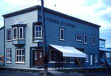
| Mme. Tremblay’s Store (16) |
|
Dawson City |
|
64°03′46″N 139°25′44″W / 64.0628°N 139.429°W / 64.0628; -139.429 (Mme. Tremblay’s Store (16)) |
9826 |
|
|
|
 |
| Harrington’s Store (15) |
|
Dawson City |
|
64°03′38″N 139°26′02″W / 64.0606°N 139.434°W / 64.0606; -139.434 (Harrington’s Store (15)) |
9829 |
|
|
|
More images |
| North West Mounted Police Stables |
|
Dawson City |
|
64°03′26″N 139°26′17″W / 64.0572°N 139.438°W / 64.0572; -139.438 (North West Mounted Police Stables) |
9842 |
|
|
|
|
| North West Mounted Police Jail |
|
Dawson City |
|
64°03′25″N 139°26′13″W / 64.057°N 139.437°W / 64.057; -139.437 (North West Mounted Police Jail) |
9854 |
|
|
|
|
| Northern Commercial Company Warehouse |
|
Dawson City |
|
64°03′42″N 139°25′37″W / 64.0617°N 139.427°W / 64.0617; -139.427 (Northern Commercial Company Warehouse) |
10373 |
|
|
|
|
| Root Cellar |
|
Dawson City |
|
64°01′39″N 139°14′46″W / 64.0276°N 139.246°W / 64.0276; -139.246 (Root Cellar) |
|
|
|
|
|
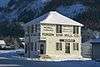
| General Manager's House |
|
Dawson City |
|
64°01′39″N 139°14′35″W / 64.0276°N 139.243°W / 64.0276; -139.243 (General Manager's House) |
11213 |
|
|
|
|
| Tr'ochëk National Historic Site |
|
Dawson City |
|
64°03′04″N 139°26′28″W / 64.0512°N 139.441°W / 64.0512; -139.441 (Tr'ochëk National Historic Site) |
14661 |
|
|
|
 |
| Dawson Daily News |
123 3rd Avenue |
Dawson City |
|
64°03′43″N 139°25′55″W / 64.062°N 139.432°W / 64.062; -139.432 (Dawson Daily News) |
11264 |
|
|
|
 |
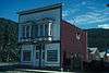
| Yukon Sawmill Company Office |
1302 Front Street |
Dawson City |
Y0B |
64°03′57″N 139°25′48″W / 64.0657°N 139.43°W / 64.0657; -139.43 (Yukon Sawmill Company Office) |
|
4832 |
|
|
More images |
| Ruby's Place |
233 Second Avenue |
Dawson City |
|
64°03′41″N 139°26′02″W / 64.0615°N 139.434°W / 64.0615; -139.434 (Ruby's Place) |
10372 |
|
|
|
 |
| Third Avenue Hotel, Building 14 |
309-11 Third Avenue |
Dawson City |
|
64°03′45″N 139°25′52″W / 64.0625°N 139.431°W / 64.0625; -139.431 (Third Avenue Hotel, Building 14) |
6227 |
|
|
|
|
| Commanding Officer's Residence (10) |
508 Fifth Avenue |
Dawson City |
|
64°03′17″N 139°26′17″W / 64.0547°N 139.438°W / 64.0547; -139.438 (Commanding Officer's Residence (10)) |
9825 |
|
|
|
|
| Dawson City Telegraph Office |
512 Seventh Avenue |
Dawson City |
Y0B |
64°03′21″N 139°25′59″W / 64.0558°N 139.433°W / 64.0558; -139.433 (Dawson City Telegraph Office) |
|
3920 |
|
|
More images |
| Old Territorial Administration Building National Historic Site |
595 Fifth Avenue |
Dawson City |
|
64°03′21″N 139°26′13″W / 64.0559°N 139.437°W / 64.0559; -139.437 (Old Territorial Administration Building National Historic Site) |
15784 |
|
|
|
 |
| St. Andrew's Manse |
601 Fourth Avenue |
Dawson City |
|
64°03′45″N 139°25′52″W / 64.0625°N 139.431°W / 64.0625; -139.431 (St. Andrew's Manse) |
10364 |
|
|
|
|
| Auto Repair Shop, Building #7 |
Bear Creek Compound |
Dawson City |
|
64°01′37″N 139°14′35″W / 64.027040°N 139.243150°W / 64.027040; -139.243150 (Auto Repair Shop, Building #7) |
6232 |
|
|
|
|
| Carpentry Shop, Building #6 |
Bear Creek Compound |
Dawson City |
|
64°01′36″N 139°14′36″W / 64.026790°N 139.243270°W / 64.026790; -139.243270 (Carpentry Shop, Building #6) |
6235 |
|
|
|
|
| Cat Repair Shop, Building #8 |
Bear Creek Compound |
Dawson City |
|
64°01′37″N 139°14′34″E / 64.027030°N 139.242830°E / 64.027030; 139.242830 (Cat Repair Shop, Building #8) |
6242 |
|
|
|
|
| Troberg Residence, Building #67 |
Bear Creek Compound |
Dawson City |
|
64°01′48″N 139°14′16″W / 64.029890°N 139.237770°W / 64.029890; -139.237770 (Troberg Residence, Building #67) |
9890 |
|
|
|
|
| Warehouse No. 1, Building #27 |
Bear Creek Compound |
Dawson City |
|
64°01′38″N 139°14′40″W / 64.027120°N 139.244450°W / 64.027120; -139.244450 (Warehouse No. 1, Building #27) |
9923 |
|
|
|
|
| Warehouse No. 3, Building #35 |
Bear Creek Compound |
Dawson City |
|
64°01′38″N 139°14′45″W / 64.027170°N 139.245870°W / 64.027170; -139.245870 (Warehouse No. 3, Building #35) |
9924 |
|
|
|
|
| Engineering Office (Building 19) |
Bear Creek Compound |
Dawson City |
|
64°01′40″N 139°14′37″W / 64.027680°N 139.243530°W / 64.027680; -139.243530 (Engineering Office (Building 19)) |
|
|
|
|
|
| Engineering Office (Building 28) |
Bear Creek Compound |
Dawson City |
|
64°01′38″N 139°14′41″W / 64.027240°N 139.244700°W / 64.027240; -139.244700 (Engineering Office (Building 28)) |
|
|
|
|
|
| Gold Room. Building #29 |
Bear Creek Compound |
Dawson City |
|
64°01′39″N 139°14′44″W / 64.027470°N 139.24552°W / 64.027470; -139.24552 (Gold Room. Building #29) |
11214 |
|
|
|
|
| Machine Shop, Building #1 & #2 |
Bear Creek Compound |
Dawson City |
|
64°01′37″N 139°14′38″W / 64.026860°N 139.24383°W / 64.026860; -139.24383 (Machine Shop, Building #1 & #2) |
11226 |
|
|
|
|
| St. Andrew's Presbyterian Church |
Church / Fourth Street |
Dawson City |
|
64°03′45″N 139°25′52″W / 64.0625°N 139.431°W / 64.0625; -139.431 (St. Andrew's Presbyterian Church) |
10366 |
|
|
|
.jpg)
More images |
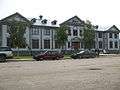
| Former Territorial Court House National Historic Site |
Corner of Front and Turner Streets |
Dawson City |
|
64°03′23″N 139°26′28″W / 64.0563°N 139.441°W / 64.0563; -139.441 (Former Territorial Court House National Historic Site) |
12743 |
|
|
|
 |
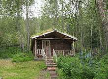
| Robert Service Cabin |
Eighth / Hansen Street |
Dawson City |
|
64°03′45″N 139°25′52″W / 64.0625°N 139.431°W / 64.0625; -139.431 (Robert W. Service#Dawson City cabinRobert Service Cabin) |
10368 |
|
|
|
 |
| Black Residence, No. 9 |
Fifth Avenue and Turner Street |
Dawson City |
|
64°03′15″N 139°26′17″W / 64.0542°N 139.438°W / 64.0542; -139.438 (Black Residence, No. 9) |
6226 |
|
|
|
|
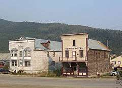
| Yukon Hotel National Historic Site |
First Avenue |
Dawson City |
Y0B |
64°03′33″N 139°26′17″W / 64.0591°N 139.438°W / 64.0591; -139.438 (Yukon Hotel National Historic Site) |
9163 |
|
|
|
More images |
| Commissioner's Residence |
Front Street |
Dawson City |
|
64°03′24″N 139°26′28″W / 64.0567°N 139.441°W / 64.0567; -139.441 (Commissioner's Residence) |
15641 |
|
|
|
 |
| Courthouse |
Front Street |
Dawson City |
|
64°03′45″N 139°25′52″W / 64.0625°N 139.431°W / 64.0625; -139.431 (Courthouse) |
16081 |
|
|
|
|
| Post Office |
King Street and Third Avenue |
Dawson City |
|
64°03′47″N 139°25′52″W / 64.063°N 139.431°W / 64.063; -139.431 (Post Office) |
11629 |
|
|
|
 |
| Winaut's Store |
Second Avenue |
Dawson City |
|
64°03′23″N 139°26′10″W / 64.0565°N 139.436°W / 64.0565; -139.436 (Winaut's Store) |
6241 |
|
|
|
|
| Dawson Historical Complex National Historic Site |
Third Avenue |
Dawson City |
Y0B |
64°03′48″N 139°25′52″W / 64.0634°N 139.431°W / 64.0634; -139.431 (Dawson Historical Complex National Historic Site) |
6253 |
|
|
|
 |
| Mabel Mcintyre House |
12 Centre Street |
Mayo |
Y0B |
63°35′36″N 135°53′46″W / 63.5932°N 135.896°W / 63.5932; -135.896 (Mabel Mcintyre House) |
|
1282 |
|
|
|
| Mayo Legion Hall |
310 First Ave |
Mayo |
Y0B |
63°35′28″N 135°53′42″W / 63.5912°N 135.895°W / 63.5912; -135.895 (Mayo Legion Hall) |
|
6585 |
|
|
|
| SS Klondike National Historic Site |
|
Whitehorse |
|
60°42′48″N 135°02′53″W / 60.7133°N 135.048°W / 60.7133; -135.048 (SS Klondike National Historic Site) |
9348 |
|
|
|
More images |
| Train Crew's House 1 |
1091 First Ave |
Whitehorse |
|
60°43′07″N 135°02′56″W / 60.7187°N 135.049°W / 60.7187; -135.049 (Train Crew's House 1) |
|
|
15133 |
|
|
| Train Crew's House 2 |
1093 First Avenue |
Whitehorse |
|
60°43′08″N 135°02′56″W / 60.7188°N 135.049°W / 60.7188; -135.049 (Train Crew's House 2) |
|
|
15134 |
|
|
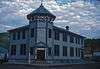
| Old Firehall |
1105 First Avenue |
Whitehorse |
Y1A |
60°43′10″N 135°03′00″W / 60.7195°N 135.05°W / 60.7195; -135.05 (Old Firehall) |
|
|
14867 |
|
.jpg) |
| White Pass and Yukon Route Railway Depot |
1109 First Ave |
Whitehorse |
Y1A |
60°43′12″N 135°03′00″W / 60.7201°N 135.05°W / 60.7201; -135.05 (White Pass and Yukon Route Railway Depot) |
|
|
4471 |
|
More images |
| Building 200 |
200 Range Road |
Whitehorse |
|
60°44′17″N 135°05′17″W / 60.7381°N 135.088°W / 60.7381; -135.088 (Building 200) |
10792 |
|
|
|
|
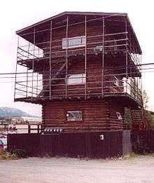
| Log Skyscrapers |
208 Lambert Street |
Whitehorse |
Y1A |
60°43′04″N 135°03′07″W / 60.7179°N 135.052°W / 60.7179; -135.052 (Log Skyscrapers) |
|
|
1903 |
|
 |
| T.C. Richards Building |
302 Steele Street |
Whitehorse |
Y1A |
60°43′12″N 135°03′18″W / 60.72°N 135.055°W / 60.72; -135.055 (T.C. Richards Building) |
|
|
4574 |
|
|
| Donnenworth House |
3126 Third Avenue |
Whitehorse |
Y1A |
60°43′13″N 135°03′18″W / 60.7204°N 135.055°W / 60.7204; -135.055 (Donnenworth House) |
|
|
6592 |
|
|
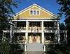
| The Taylor House |
412 Main Street |
Whitehorse |
Y1A |
60°43′08″N 135°03′29″W / 60.7188°N 135.058°W / 60.7188; -135.058 (The Taylor House) |
|
4833 |
|
|
|
| Pioneer Hotel 2 |
Shipyards Park |
Whitehorse |
Y1A |
60°43′42″N 135°03′18″W / 60.7284°N 135.055°W / 60.7284; -135.055 (Pioneer Hotel 2) |
|
|
8904 |
|
|