List of listed buildings in Lochlee, Angus
This is a list of listed buildings in the parish of Lochlee in Angus, Scotland.
List
| Name | Location | Date Listed | Grid Ref. [note 1] | Geo-coordinates | Notes | HB Number [note 2] | Image |
|---|---|---|---|---|---|---|---|
| St. Drostan's Episcopal Church, Tarfside | 56°54′23″N 2°50′13″W / 56.906495°N 2.836945°W | Category B | 13748 | 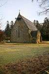
| |||
| Lochlee Old Parish Church And Churchyard | 56°54′24″N 2°50′15″W / 56.906742°N 2.837624°W | Category C(S) | 11356 | 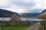
| |||
| Maule Memorial Church, Tarfside (Former Free Church) | 56°54′12″N 2°49′42″W / 56.903372°N 2.82837°W | Category B | 11359 | 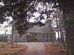
| |||
| Tarfside Bridge Over Water Of Tarf | 56°54′22″N 2°50′10″W / 56.906123°N 2.836083°W | Category C(S) | 11360 | 
| |||
| Invermark Lodge Stables | 56°54′51″N 2°55′19″W / 56.914072°N 2.921911°W | Category C(S) | 50721 |
| |||
| Maule Monument, Craig Of Migvie Or Hill Of Rowan | 56°54′19″N 2°49′59″W / 56.905227°N 2.833074°W | Category B | 11353 | 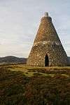
| |||
| Cross Stone At Tarfside | 56°54′23″N 2°50′55″W / 56.906443°N 2.848685°W | Category B | 11355 |
| |||
| Dalbrack Bridge | 56°53′35″N 2°52′22″W / 56.893107°N 2.872774°W | Category C(S) | 11363 |
| |||
| House Of Mark With Former Steading Range, Walled Garden, Bothy And Pig Sty | 56°54′48″N 2°54′54″W / 56.913404°N 2.91503°W | Category C(S) | 11348 |
| |||
| Invermark Lodge | 56°54′47″N 2°55′34″W / 56.912972°N 2.926154°W | Category B | 11350 | 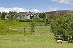
| |||
| Chapel Near Burn Of Rowan | 56°54′31″N 2°51′12″W / 56.908604°N 2.853266°W | Category C(S) | 11354 |
| |||
| St. Andrew's Tower Near Auchintoul | 56°53′51″N 2°46′44″W / 56.897375°N 2.77884°W | Category B | 11361 | 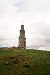
| |||
| Corn Mill, Aucheen | 56°54′06″N 2°45′29″W / 56.901537°N 2.758026°W | Category B | 11362 | 
| |||
| Kirkton Old House And Shepherd's Bothy With Ancillary Building | 56°54′37″N 2°56′04″W / 56.910215°N 2.934412°W | Category C(S) | 50723 |
| |||
| Invermark Lodge Kennels With East And West Bothies | 56°54′38″N 2°56′08″W / 56.910495°N 2.935454°W | Category C(S) | 50719 |
| |||
| Lochlee Parish Church And Churchyard (Church Of Scotland) | 56°54′42″N 2°54′43″W / 56.911755°N 2.912017°W | Category B | 11346 | .JPG)
| |||
| Inchgrundle With Ancillary Buildings | 56°53′57″N 2°58′05″W / 56.899303°N 2.96819°W | Category C(S) | 11357 |
| |||
| Invermark Lodge Deer Larder | 56°54′45″N 2°55′42″W / 56.912596°N 2.928313°W | Category C(S) | 11351 | 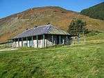
| |||
| Gleneffock Bridge | 56°53′53″N 2°53′33″W / 56.898087°N 2.892607°W | Category C(S) | 11352 | 
| |||
| Glen Mark, The Queen's Well | 56°56′00″N 2°57′18″W / 56.933229°N 2.954953°W | Category C(S) | 11358 | 
| |||
| Invermark Castle | 56°54′41″N 2°55′03″W / 56.911498°N 2.917627°W | Category A | 11349 | 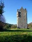
|
Key
The scheme for classifying buildings in Scotland is:
- Category A: "buildings of national or international importance, either architectural or historic, or fine little-altered examples of some particular period, style or building type."[1]
- Category B: "buildings of regional or more than local importance, or major examples of some particular period, style or building type which may have been altered."[1]
- Category C(S): "buildings of local importance, lesser examples of any period, style, or building type, as originally constructed or moderately altered; and simple traditional buildings which group well with others in categories A and B."[1]
There are approximately 47,400 listed buildings in Scotland. Of these, around 8 per cent (some 3,800) are Category A, and 51 per cent (24,000) are Category B, with the rest listed at Category C(s).[2]
See also
Notes
- ↑ Sometimes known as OSGB36, the grid reference (where provided) is based on the British national grid reference system used by the Ordnance Survey.
• "Guide to National Grid". Ordnance Survey. Retrieved 2007-12-12.
• "Get-a-map". Ordnance Survey. Retrieved 2007-12-17. - ↑ The "HB Number" is a unique number assigned to each listed building by Historic Scotland.
References
- All entries, addresses and coordinates are based on data from Historic Scotland. This data falls under the Open Government Licence
- 1 2 3 "What is Listing?". Historic Scotland. Retrieved 2010-07-06.
- ↑ Guide to the Protection of Scotland’s Listed Buildings (PDF). Historic Scotland. 2009. p. 17. ISBN 978-1-84917-013-0. Retrieved 2010-07-06.
This article is issued from Wikipedia - version of the 10/15/2016. The text is available under the Creative Commons Attribution/Share Alike but additional terms may apply for the media files.