List of neighborhoods in North Bergen, New Jersey

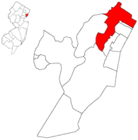
Map highlighting North Bergen within Hudson County. Inset: Location of Hudson County in New Jersey.
The following is a list of neighborhoods in North Bergen, New Jersey.
- Bergenline runs to Nungesser's at the Fairview border near North Hudson Park.
- Bigleys/Three Ditches-a wetlands area between the Northeast Corridor and Secaucus Road.
- Racetrack Section-between Bergenline and Kennedy Boulevard on the palisades plateau
- Bergenwood, on the steep slopes of the west side of the Palisades
- New Durham[1] site of colonial American Three Pigeons near the Bergen Turnpike and Tonnelle Avenue
- Meadowview, behind the Municipal Building between the many cemeteries:
- Bulls Ferry on the Hudson Waterfront, site of Roc Harbor,[2] Palisades Medical Center and Hudson River Waterfront Walkway
- Babbitt from the rail station near North Bergen Yard in Meadowlands[3]
- Woodcliff on the Hudson Palisades around North Hudson Park
- Transfer Station[4] near the single point border Union City and Jersey City near Paterson Plank Road, Kennedy Boulevard, and Secaucus Road.
- Schuetzen Park/Columbia Park at Kennedy Boulevard where Hackensack Plank Road becomes the Bergen Turnpike
See also
Other historical unincorporated communities, localities and place names located partially or completely within the township include Tyler Park, Homestead,[5][6][7][8] Three Pigeons, Maisland, Granton, Hudson Heights, and Shadyside.[9]
References
- ↑ Durham Baptist Church
- ↑ Roc Harbor
- ↑ NYSW Stations
- ↑ - Transfer Station
- ↑ http://query.nytimes.com/mem/archive-free/pdf?res=9A06E0DC1530E233A25752C1A9639C946196D6CF
- ↑ http://mikethehistoryguy.blogspot.nl/2014_01_01_archive.html
- ↑ http://www.northernbranchcorridor.com/docs/Northern%20Branch%20DOCS/Northern%20Branch%20DEIS%20Appendices/Appendix%20H%20-%20Historic.pdf
- ↑ https://books.google.nl/books?id=G1ENevqcHHcC&pg=PA9&lpg=PA9&dq=homestead+new+jersey+railroad+erie&source=bl&ots=rVhPYPt-wH&sig=xkKSlZS-8kdHn7TzeWp_5bcfsEE&hl=en&sa=X&redir_esc=y#v=onepage&q=homestead%20new%20jersey%20railroad%20erie&f=false
- ↑ Locality Search, State of New Jersey. Accessed May 21, 2015.
Sources
Hudson County New Jersey Street Map. Hagstrom Map Company, Inc. 2008. ISBN 0-88097-763-9.
This article is issued from Wikipedia - version of the 9/18/2016. The text is available under the Creative Commons Attribution/Share Alike but additional terms may apply for the media files.
