Lucerne railway station
Luzern (Lucerne railway station) | |
|---|---|
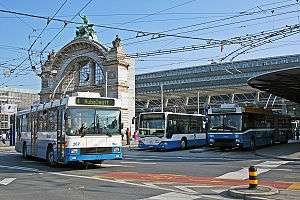
 Bus station in front of the railway station in Lucerne | |
| Location |
Bahnhofplatz, 6003 Lucerne, Canton of Lucerne, Switzerland |
| Coordinates | 47°2′56″N 8°18′38″E / 47.04889°N 8.31056°ECoordinates: 47°2′56″N 8°18′38″E / 47.04889°N 8.31056°E |
| Owned by | SBB-CFF-FFS |
| Operated by |
SBB-CFF-FFS Zentralbahn |
| Line(s) |
Zürich–Lucerne Gotthard (Lucerne branch) Olten–Lucerne Bern–Wolhusen–Lucerne Brünig railway |
| Platforms | 14 |
| Connections |
Lucerne trolleybuses Lucerne buses SGV ships |
| Construction | |
| Architect |
Ammann + Baumann, Santiago Calatrava |
| History | |
| Opened | 1856 |
| Rebuilt | 1896, 1980- |
| Electrified | 1922 |
| Location | |
 Luzern Location within Switzerland | |
Lucerne railway station (German: Bahnhof Luzern) is a major hub of the rail network of Switzerland, in the city of Lucerne in the canton of Lucerne. It is a terminal station serving domestic and international traffic on several rail lines, and is situated in a city centre and waterfront location on the south side of Lake Lucerne.[1][2]
History
The first station was opened on edge of Lake Lucerne in 1856 at the end of the Schweizerische Centralbahn main line from Olten and Basel where it connected with the French and German railways. The route of the railway—now the course of Pilatusstrasse (Pilatus Street)—was still undeveloped. The terminal station led directly to the pier for boat services on the lake and to the gates of the city of Lucerne. As a result, the area at the lake shore developed into an important railway junction. In the 19th century it rapidly developed into a hub with the introduction of steam navigation on the lake and the construction of several railway lines: the Gotthard railway, the line to Bern via Wolhusen, the line to Zug and Zürich and the metre-gauge Brünig railway. The first station was made of wood.
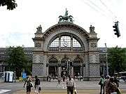
A new station was opened in 1896 with a large new building with a distinctive cupola. It was turned at almost 90° to the original station with its end to the north towards the bridge to central Lucerne, requiring a significantly changed approach line. The new approach had no level crossings of streets unlike the original route, but instead ran on embankments or in cuttings. The Brünig railway was also integrated into the new station. The tracks were electrified in 1922 along with the line from Olten. By 1910 the new station was nearing its capacity limits and an expansion plan was developed. However, the start of World War I prevented any work being carried out.
On the morning of 5 February 1971 fire broke out in the staff quarters of station. The building burnt fiercely, and within an hour the cupola had collapsed, destroying the station frontage and concourse.[3] The service was restored with temporary buildings, allowing operations to be recommenced. In 1980 a partnership of the Swiss Federal Railways, Swiss Post, the city and canton of Lucerne launched an architecture competition for a comprehensive redevelopment of the station. This also considered the future development of the rail approaches to Lucerne. However, a through station with a tunnel under Lake Lucerne was ruled out.
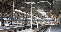
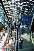
A new station was eventually built, and opened on 5 February 1991, exactly 20 years after its predecessor was destroyed. The new station was planned by the architectural firm of Ammann and Baumann, and their then employee, Santiago Calatrava, designed the concourse of the new station. This is said to be the "heart of the new station, ... a multi-storey, generous sized public space that links the various functions of the city center with the railway". Its platforms are longer than those of the old station, and the underground shopping arcade is much larger.[3][4]
In late 2012, a new tunnel route was opened on the Brünig line, between Kriens Mattenhof station and the approaches to Lucerne station. The tunnel replaces a less direct surface alignment, allowing the abolition of several congested level crossings and the provision of double track, but terminal platforms used by Brünig line trains remain unchanged.[5][6]
|
Operation
The station is a terminal station serving domestic and international traffic on several rail lines. The lines from the east (Zürich–Lucerne and the Gotthard lines) pass to the north of Lucerne and then join the lines from the north (Olten–Lucerne line) and the west (Bern–Wolhusen–Lucerne line) and pass to the west of Lucerne before turning to approach the station from the south. The metre-gauge Brünig railway from the south and Interlaken also terminates at the station.[1][2]
Bahnhofplatz occupies the area between the front of the station and the lakefront, and is heavily used by the local buses. The landing stages used by the passenger ships of the Schifffahrtsgesellschaft des Vierwaldstättersees (SGV) occupy the lakeside of Bahnhofplatz, providing interchange between rail and water transport. An underground shopping mall lies below both the concourse of the railway station and Bahnhofplatz.[1][7]
|
Future proposals
In 2009 a study was initiated into the building of a new underground through station next to the current terminus, and after studying some 30 variants, the chosen variant was announced in July 2013. This involves the construction of a new 3.5-kilometre (2.2 mi) tunnel from Ebikon station, on the Zürich to Lucerne line, under the end of Lake Lucerne to an interim underground terminal station immediately to the east of the existing station. A second phase will add a second, 2-kilometre-long (1.2 mi), tunnel to join the standard gauge approach to the existing station at Heimbach, thus converting the underground station into a through station.[8]
If executed, this will significantly increase capacity on the Zürich to Lucerne line, by avoiding a single-track section of the existing line, and avoiding conflicts with the other standard gauge lines into the station. However, before the line can be built, the line must be funded. The first phase alone is estimated to cost CHF2.4 billion, and will be the subject of legislation and a national referendum, probably in 2014.[8]
References
- 1 2 3 map.geo.admin.ch (Map). Swiss Confederation. Retrieved 2013-10-26.
- 1 2 Eisenbahnatlas Schweiz. Verlag Schweers + Wall GmbH. 2012. p. 22. ISBN 978-3-89494-130-7.
- 1 2 "Lucerne pioneers the modern railway station". swissinfo.ch. Swiss Broadcasting Corporation. Retrieved 2013-10-27.
- ↑ Disch, Peter (1991). Architektur in der deutsche Schweiz 1980-1990. Ein Katalog und Architekturführer. Lugano: ADV-Verlag. p. 146. ISBN 88-7922-000-4.
- ↑ "Ausbau Zentralbahn" [Zentralbahn Expansion] (in German). Retrieved 2013-01-15.
- ↑ "Ausbau Zentralbahn - Ziele und Nutzen" [Zentralbahn Expansion - Objectives and Benefits] (in German). Retrieved 2013-01-15.
- ↑ "Luzern station plan" (PDF). Swiss Federal Railways. Retrieved 2013-10-26.
- 1 2 "New underground station for Luzern". Today's Railways Europe. Platform 5 Publishing Ltd. November 2013. p. 8.
External links
![]() Media related to Lucerne railway station at Wikimedia Commons
Media related to Lucerne railway station at Wikimedia Commons
.jpg)
.jpg)


