Madhurawada
| Madhurawada మధురవాడ | |
|---|---|
| Suburban area in Visakhapatnam | |
|
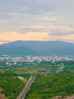
Far view of Madhurawada | |
 Madhurawada Location in Andhra Pradesh, India | |
| Coordinates: 17°48′06″N 83°21′12″E / 17.80167°N 83.35333°ECoordinates: 17°48′06″N 83°21′12″E / 17.80167°N 83.35333°E | |
| Country |
|
| State | Andhra Pradesh |
| District | Visakhapatnam |
| Government | |
| • Body | Greater Visakhapatnam Municipal Corporation |
| Languages | |
| • Official | Telugu |
| Time zone | IST (UTC+5:30) |
| PIN | 530048 |
| Vehicle registration | AP 31 and AP 32 |
Madhurawada is a major suburb of Visakhapatnam City in the Andhra Pradesh State. It is located on the Visakhapatnam-Vizianagaram stretch of National Highway 5 at around 16km from Visakhapatnam City. Cricket stadium in Visakhapatnam lies in this suburb. It is famous for a missionary school named St. Francis School. This school is a well known school in India. Shilparamam in Visakhapatnam also lies here. This area consists many well-known areas like Pothinamallayya Palem, Mithilapur VUDA colony,Revallapalem,Ganeshnagar and Port colony.
History
Madhurawada is a Pre Historical Neolithic site[1] along the Eastern Ghats surrounding the city of Visakhapatnam. Trail excavations were carried out around Madhurawada and some Megalithic and Neolithic remnants were found. Trail excavations are documented by A professor from Andhra University, Visakhapatnam.
References
| Wikimedia Commons has media related to Madhurawada. |

