Mangan subdivision
| Mangan | |
|---|---|
| Subdivision | |
|
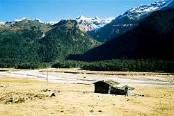
A hut in the Yumthang Valley. | |
 Mangan subdivision's location in North Sikkim. | |
| Country | India |
| State | Sikkim |
| District | North Sikkim |
| Time zone | IST (UTC+5:30) |
| ISO 3166 code | IN-SK |
Mangan subdivision is one of the two sub-districts of North Sikkim district, in the state of Sikkim, India.[1] Mangan is the headquarters.[1] It contains 46 census-designated villages:[2]
- Naga-Namgor
- Meyong
- Singchit
- Pakshep
- Kazor
- Sentam
- Salim Pakel
- Lingthem
- Lingdem
- Tingbong
- Lingzah-Tolung
- Sakyong-Pentong
- Lum
- Sangtok
- Gor
- Gnon-Samdong
- Hee-Gyathang
- Barfok
- Lingdong
- Zimchung
- Singhik
- Ringhim
- Nampatam
- Tingchim
- Upper Mangshila
- Lower Mangshila
- Namok
- Sheyam
- Tangyek
- Ramthamg
- Rongong
- Tumlong
- Phodong
- Chawang
- Phamtam
- Men-Rongong
- Paney-Phensong
- Labi
- Kabi
- Tingda
- Upper Dzongu Forest Block
- Lower Dzongu Forest Block
- Naga Forest Block
- Mangan Forest Block
- Phodong Forest Block
- Kabi Forest Block
References
- 1 2 Sikkim Administrative Divisions (PDF) (Map). The Registrar General & Census Commissioner, India, New Delhi, Ministry of Home Affairs, Government of India. 2011. Retrieved 2011-09-29.
- ↑ "MDDS e-Governance Code (Sikkim Rural)" (PDF). Office of the Registrar General & Census Commissioner, India. 2011. Retrieved 2011-10-15.
This article is issued from Wikipedia - version of the 9/20/2016. The text is available under the Creative Commons Attribution/Share Alike but additional terms may apply for the media files.
