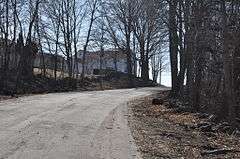
March Route of Rochambeau's Army: Old Canterbury Road
|
March Route of Rochambeau's Army: Old Canterbury Road | |
|
Old Canterbury Road in 2016 | |
  | |
| Location | Old Canterbury Rd: Canterbury Rd. from Jct. with Old Canterbury Rd., Plainfield, Connecticut |
|---|---|
| Coordinates | 41°41′22″N 71°57′4″W / 41.68944°N 71.95111°WCoordinates: 41°41′22″N 71°57′4″W / 41.68944°N 71.95111°W |
| Area | 2 acres (0.81 ha) |
| MPS | Rochambeau's Army in Connecticut, 1780-1782 MPS |
| NRHP Reference # | 03000310[1] |
| Significant dates | |
| Dates of significance | 1781, 1782 |
| Added to NRHP | June 6, 2003 |
March Route of Rochambeau's Army: Old Canterbury Road is a historic site in Plainfield, Connecticut along the 1781 and/or 1782 march routes of Rochambeau's army. It includes a stretch of what is now Old Canterbury Road and a stretch of Canterbury Road (Connecticut Route 14 A). It is a 2-acre (0.81 ha) site that was listed on the National Register of Historic Places in 2003.[1][2]
This particular segment of the route was deemed historically significant in 2002 "because it allows one to imagine the appearance of the Connecticut countryside--the cultivated fields, woods, stone walls, and narrow, windy roads--that the French army encountered as it made its way to and from the Battle of Yorktown, the engagement that decided the outcome of the American Revolution". It was traversed by Rochambeau's troops in June 1781 on their way to Virginia, and again in November 1782, on their return to Rhode Island.[2]
Part of the site is a "narrow, curving paved road", with a border of shrubs and vines and stone walls along much of its length. A stand of mature Sugar Maple trees gives shade to a portion of the site. Houses along the section are more modern than the 1781-82 era, but are set back far enough so as not to interfere with the evocation of Rochambeau's marching troops.[2]
At the east end of the segment, stone walls are preserved on both sides of the road, and, as of 2002, "there are expansive views of plowed fields and pasture both to the north and to the south".[2]
The passage of the French army along this route is documented by period route map drawn by French military engineer Louis-Alexandre Berthier, republished by Rice and Brown in 1972 and reproduced in the 2002 NRHP nomination document.[2]
It's one of multiple historic sites associated with the Rochambeau march route whose NRHP listing eligibility was defined by a multiple property study in 2001.[3]
See also
References
- 1 2 National Park Service (2009-03-13). "National Register Information System". National Register of Historic Places. National Park Service.
- 1 2 3 4 5 Mary Harper and Bruce Clouette (December 5, 2002). "National Register of Historic Places Registration: March Route of Rochambeau's Army: Old Canterbury Road" (PDF). National Park Service. and Accompanying eight photos, from 2001 (see photo captions page 12 of text document)
- ↑ Bruce Clouette and Mary Harper (October 22, 2001). "National Register of Historic Places Multiple Property Documentation: Rochambeau's Army in Connecticut, 1780-1782 MPS" (PDF). National Park Service.
