Mardin High

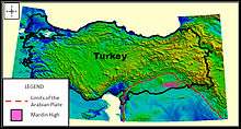
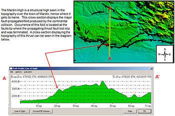
The Mardin High is a structural high seen in the topography around the town of Mardin, Turkey where it gets its name. A cross-section displays the major fault-propagated fold produced by the continental collision. Occurrence of this fold is located at the faults tip where the propagating thrust fault lost slip and was terminated.
Turkey consists of several structural basins which are a direct response of the tectonic processes of continental collision. There are seven onshore basins in Turkey that pose an interest in those interested in hydrocarbon exploration. These basins consists of organic sediments that were deposited millions of years ago that now have matured into natural resources such as oil and gas. Triassic and Cretaceous aged reservoirs are the most well known sediments in the northern extent of this basin.

The Basin that is the most actively oil prone out of the seven is located in SE Turkey, and known as the Anatolian Basin or the Mardin High. Southeast Turkeys 90,000 square kilometer Anatolian Basin is the northern part of the overall Middle Eastern sedimentary basin, which consists of the similar oil fields of Syria, Iraq and Iran. Although the Anatolian Basin is the most attractive Basin in Turkey, it contains a considerably lower amount of reservoir and source rocks than those found in other areas of the Middle East. The Anatolian Basin is geologically located on the northern extension of the Arabian plate. Crustal shortening and thickening can be seen from areal imagery directly above the Arabian Plate. Mostly Alpine orogenic movements and some older Hercynian compressional movements of the Arabian plate northward created East-West anticlinal structural traps within the Anatolian Basin.