Mississippi Highway 7
"MS 7" redirects here. MS 7 may also refer to Mississippi's 7th congressional district.
| ||||
|---|---|---|---|---|
| Route information | ||||
| Maintained by MDOT | ||||
| Length: | 139.482 mi[1] (224.475 km) | |||
| Major junctions | ||||
| South end: |
| |||
|
| ||||
| North end: |
| |||
| Location | ||||
| Counties: | Humphreys, Leflore, Carroll, Grenada, Yalobusha, Lafayette, Marshall, Benton | |||
| Highway system | ||||
| ||||

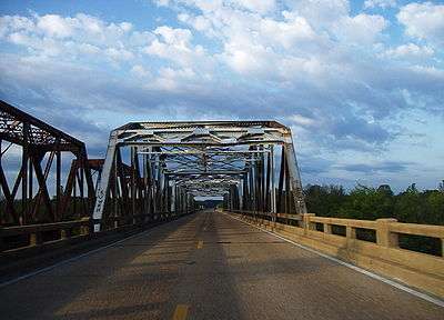
Highway 7 and rarely used Mississippi Central Railroad bridges over the Tallahatchie River at the Lafayette-Marshall county line. This sweeping bottomland, located approximately halfway between Holly Springs and Oxford, was the inspiration for fictional settings in several works by William Faulkner. This bridge was replaced and removed in 2015.[2]
Mississippi Highway 7 runs generally north–south from the Tennessee state line in Benton County to Belzoni, Mississippi. It travels approximately 165 miles (266 km), serving Humphreys, Leflore, Carroll, Grenada, Yalobusha, Lafayette, Marshall, and Benton Counties. It runs nearly parallel to the rarely used Mississippi Central Railroad.
Points of interest
Locales on route
From north to south
- Michigan City near the Tennessee state line (above which the highway becomes State Route 18)
- Lamar
- Holly Springs
- Oxford
- Water Valley
- Grenada
- Greenwood
- Itta Bena
- Morgan City
- Belzoni
Major intersections
| County | Location | mi | km | Destinations | Notes |
|---|---|---|---|---|---|
| Humphreys | Belzoni | ||||
| Leflore | | south end of US 82 overlap | |||
| Greenwood | south end of US 49E overlap | ||||
| interchange; north end of US 49E overlap | |||||
| no left turn northbound | |||||
| north end of US 82 overlap | |||||
| Grenada | Holcomb | south end of MS 8 / MS 35 overlap | |||
| north end of MS 35 overlap | |||||
| Grenada | north end of MS 8 overlap; south end of I-55 overlap; MS 7 south follows exit 206 | ||||
| Papermill Road - North Grenada | I-55 exit 208 | ||||
| | north end of I-55 overlap; south end of MS 333 Scenic overlap; MS 7 north follows exit 211 | ||||
| | north end of MS 333 Scenic overlap | ||||
| Yalobusha | Coffeeville | ||||
| | south end of MS 315 overlap | ||||
| Water Valley | north end of MS 315 overlap | ||||
| Lafayette | | ||||
| | |||||
| Oxford | interchange; south end of freeway | ||||
| interchange | |||||
| Sisk Avenue | interchange | ||||
| interchange; north end of freeway | |||||
| Abbeville | |||||
| Marshall | | ||||
| | south end of MS 4 overlap | ||||
| Holly Springs | I-22 exit 30 | ||||
| north end of MS 4 overlap; former MS 178 east | |||||
| former MS 178 west | |||||
| northern bypass of Holly Springs | |||||
| | |||||
| Benton | | Lamar ( | |||
| | |||||
| | Harris Chapel Road | proposed MS 5 south | |||
| | Michigan City ( | ||||
| | Tennessee state line | ||||
| 1.000 mi = 1.609 km; 1.000 km = 0.621 mi | |||||
See also
 Mississippi portal
 U.S. Roads portal
References
- ↑ "Mississippi Public Roads Selected Statistics" (PDF). Mississippi Department of Transportation. 2008. Retrieved 2010-06-03.
- ↑ "Generation of Ole Miss Students, Oxford Citizens Mourn Demise of Hwy. 7 Bridge Across Tallahatchie River". HottyToddy.com. February 25, 2015. Archived from the original on February 26, 2016. Retrieved February 26, 2016.
This article is issued from Wikipedia - version of the 6/29/2016. The text is available under the Creative Commons Attribution/Share Alike but additional terms may apply for the media files.

