Monona, Wisconsin
| Monona, Wisconsin | |
|---|---|
| City | |
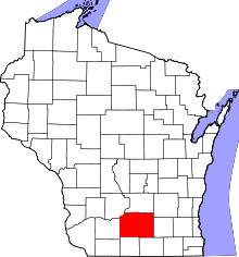
 Location in Dane County and the state of Wisconsin. | |
| Coordinates: 43°3′25″N 89°20′1″W / 43.05694°N 89.33361°WCoordinates: 43°3′25″N 89°20′1″W / 43.05694°N 89.33361°W | |
| Country | United States |
| State | Wisconsin |
| County | Dane |
| Incorporated | August 29, 1938 |
| Government | |
| • Type | City Council/Mayor |
| • Mayor | Bob Miller |
| Area[1] | |
| • Total | 3.35 sq mi (8.68 km2) |
| • Land | 3.26 sq mi (8.44 km2) |
| • Water | 0.09 sq mi (0.23 km2) |
| Elevation[2] | 879 ft (268 m) |
| Population (2010)[3] | |
| • Total | 7,533 |
| • Estimate (2014[4]) | 7,859 |
| • Density | 2,310.7/sq mi (892.2/km2) |
| Time zone | Central (CST) (UTC-6) |
| • Summer (DST) | CDT (UTC-5) |
| ZIP code | 53716 |
| Area code(s) | 608 |
| FIPS code | 55-53675[5] |
| GNIS feature ID | 1569653[2] |
| Website |
www |
Monona is a city in Dane County, Wisconsin, United States. The population was 7,533 at the 2010 census. It is completely surrounded by Madison and is part of the Madison Metropolitan Statistical Area.
Geography
Monona is located at 43°3′25″N 89°20′1″W / 43.05694°N 89.33361°W (43.057029, -89.333716).[6]
According to the United States Census Bureau, the city has a total area of 3.35 square miles (8.68 km2), of which, 3.26 square miles (8.44 km2) is land and 0.09 square miles (0.23 km2) is water.[1]
Demographics
| Historical population | |||
|---|---|---|---|
| Census | Pop. | %± | |
| 1940 | 1,323 | — | |
| 1950 | 2,544 | 92.3% | |
| 1960 | 8,178 | 221.5% | |
| 1970 | 10,420 | 27.4% | |
| 1980 | 8,809 | −15.5% | |
| 1990 | 8,637 | −2.0% | |
| 2000 | 8,018 | −7.2% | |
| 2010 | 7,533 | −6.0% | |
| Est. 2015 | 8,164 | [7] | 8.4% |
2010 census
As of the census[3] of 2010, there were 7,533 people, 3,777 households, and 1,925 families residing in the city. The population density was 2,310.7 inhabitants per square mile (892.2/km2). There were 4,088 housing units at an average density of 1,254.0 per square mile (484.2/km2). The racial makeup of the city was 92.5% White, 2.8% African American, 0.5% Native American, 1.4% Asian, 1.1% from other races, and 1.7% from two or more races. Hispanic or Latino of any race were 3.1% of the population.
There were 3,777 households of which 20.0% had children under the age of 18 living with them, 40.0% were married couples living together, 8.2% had a female householder with no husband present, 2.8% had a male householder with no wife present, and 49.0% were non-families. 40.9% of all households were made up of individuals and 15.6% had someone living alone who was 65 years of age or older. The average household size was 1.99 and the average family size was 2.71.
The median age in the city was 45.9 years. 16.9% of residents were under the age of 18; 6.7% were between the ages of 18 and 24; 24.9% were from 25 to 44; 32% were from 45 to 64; and 19.5% were 65 years of age or older. The gender makeup of the city was 47.7% male and 52.3% female.
2007 Demographics
The city population as of 2007 is 8,046 with a growth of +.0.3% since 2000. 3,838 residents (47.7%) are male and 4,208 residents (52.3%) are female. The median resident age is 41.3 years of age, slightly older than the average Wisconsin resident at 36 years. The reported racial makeup is 92.0% White, 3.2% Hispanic, 2.3% Black, 1.5% two or more races, 1.3% other race, and 0.8% American Indian.[9]
2000 City census information
As of the census[5] of 2000, there were 3,768 households, and 2,053 families residing in the city. The population density was 2,387.5 people per square mile (921.4/km²). There were 3,922 housing units at an average density of 1,167.8 per square mile (450.7/km²).
There were 3,768 households out of which 23.9% had children under the age of 18 living with them, 43.3% were married couples living together, 8.2% had a female householder with no husband present, and 45.5% were non-families. 37.0% of all households were made up of individuals and 13.8% had someone living alone who was 65 years of age or older. The average household size was 2.12 and the average family size was 2.80.
In the city the population was spread out with 20.5% under the age of 18, 6.8% from 18 to 24, 28.8% from 25 to 44, 26.3% from 45 to 64, and 17.6% who were 65 years of age or older. The median age was 41 years. For every 100 females there were 91.2 males. For every 100 females age 18 and over, there were 88.1 males.
The median income for a household in the city was $48,034, and the median income for a family was $58,635. Males had a median income of $40,267 versus $30,912 for females. The per capita income for the city was $26,072. About 2.2% of families and 5.7% of the population were below the poverty line, including 5.9% of those under age 18 and 3.1% of those age 65 or over.
Economy
The Sand County Foundation is located in Monona.
History
Monona was originally part of the Town of Blooming Grove. It was incorporated as a Village on August 29, 1938. Prior to 1938, the area mainly consisted of farmland and summer homes. However, by 1938, permanent homes and small businesses became much more common in the area.
During the 1950s, the Village of Monona grew from 2,544 to 8,178. This population increase was the largest percentage increase (231%) of any other community in the State of Wisconsin during the decade.
Due to the population increase, the Monona facilities and services was greatly expanded. In 1963, Monona built a community center and adjacent swimming pool. In 1967, a public library was built. In 1969, Monona changed to city status and built a City Hall across from the library. This building ended up housing all City operations (including the fire and police departments).
During the 1960s, commercial development significantly increased, especially along Monona Drive.
In the 1960s and 1970s, many properties were annexed by the city for residential, commercial and industrial purposes and is now surrounded by the City of Madison and by bodies of water.[10]
Indian mound discovery

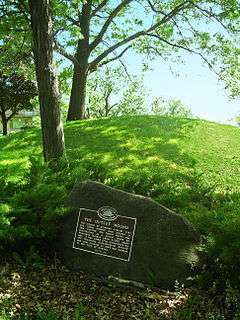
During the 1940s, a mound was unintentionally cut into during street construction and skeletons were uncovered. This Indian burial mound was thought to have been built around 1,500 years ago by the Hopewell Indians. At the time the find was declared by the State Historical Society to be one of the most important archaeological discoveries ever made in southern Wisconsin. A State of Wisconsin historical marker was placed at this site in 1998, inscribed with the following:
The Outlet Mound
“The largest of 19 conical, oval and linear mounds once located in this vicinity, the Outlet Mound was built by Woodland Indians about 2,000 years ago. Constructed as a burial place, the mound was saved from destruction by the Wisconsin Archeological Society and local citizens in 1944 and donated to the City of Monona.”
The area where the mound was discovered became known as Indian Mounds Park. It is located at the corner of Midwood and Ridgewood Avenues.[11]
It was added to the National Register of Historic Places in 2003.[12]
References
- 1 2 "US Gazetteer files 2010". United States Census Bureau. Retrieved 2012-11-18.
- 1 2 "US Board on Geographic Names". United States Geological Survey. 2007-10-25. Retrieved 2008-01-31.
- 1 2 "American FactFinder". United States Census Bureau. Retrieved 2012-11-18.
- ↑ "Population Estimates". United States Census Bureau. Retrieved 2013-06-24.
- 1 2 "American FactFinder". United States Census Bureau. Retrieved 2008-01-31.
- ↑ "US Gazetteer files: 2010, 2000, and 1990". United States Census Bureau. 2011-02-12. Retrieved 2011-04-23.
- ↑ "Annual Estimates of the Resident Population for Incorporated Places: April 1, 2010 to July 1, 2015". Retrieved July 2, 2016.
- ↑ "Census of Population and Housing". Census.gov. Retrieved June 4, 2015.
- ↑ Monona, Wisconsin (WI 53716) profile: population, maps, real estate, averages, homes, statistics, relocation, travel, jobs, hospitals, schools, crime, moving, houses, news
- ↑ City of Monona: About Monona > History
- ↑ City of Monona: Parks & Recreation > Parks & Open Spaces > Indian Mounds Park
- ↑ LandmarkHunter.com | Outlet Mound

