Mosedale, Cumbria
| Mosedale | |
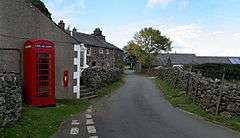
 View of Mosedale in 2009, showing phone box and post box |
|
 Mosedale |
|
| OS grid reference | NY356322 |
|---|---|
| Civil parish | Mungrisdale |
| District | Eden |
| Shire county | Cumbria |
| Region | North West |
| Country | England |
| Sovereign state | United Kingdom |
| Post town | PENRITH |
| Postcode district | CA11 |
| Dialling code | 017687 |
| Police | Cumbria |
| Fire | Cumbria |
| Ambulance | North West |
| EU Parliament | North West England |
| UK Parliament | Penrith and The Border |
Coordinates: 54°40′52″N 2°59′53″W / 54.681°N 2.998°W
_Mosedale_Meeting_House_-_geograph.org.uk_-_559048.jpg)
Mosedale is a hamlet in Eden District, Cumbria in the north west of the English Lake District. It is on the River Caldew, north east of Bowscale Fell and south east of Carrock Fell, about one mile north of Mungrisdale.[1] It is in the civil parish of Mungrisdale, which is made up of eight hamlets with a total population of 284 in 2001.[2][3] From 1866 to 1934 Mosedale was itself a civil parish.[4]
There is a Quaker meeting house in Mosedale, where meetings are held weekly in summer and fortnightly in winter. The meeting house was created in 1702 from an earlier building, was used for regular meetings until 1865, became an Anglican chapel of ease 1936-1970, and was restored for use by Quakers in 1973.[5]
See also
References
| Wikimedia Commons has media related to Mosedale. |
- ↑ "Mosedale". The Cumbria Directory. Retrieved 21 April 2014.
- ↑ "Welcome to the parish of Mungrisdale". Mungrisdale Parish Website. Retrieved 21 April 2014.
- ↑ "Parish headcounts: Eden (non-metropolitan district)". Neighbourhood Statistics. Office for National Statistics. 2004. Retrieved 21 April 2014.
- ↑ "Mosedale Tn/CP". Vision of Britain. Retrieved 21 April 2014.
- ↑ "About us". North Cumbria Area Meeting: Mosedale. Retrieved 21 April 2014.