Mystic Bridge Historic District
|
Mystic Bridge Historic District | |
 | |
  | |
| Location | U.S. 1 and CT 27, Mystic, Connecticut |
|---|---|
| Coordinates | 41°21′25″N 71°57′51″W / 41.35694°N 71.96417°WCoordinates: 41°21′25″N 71°57′51″W / 41.35694°N 71.96417°W |
| Area | 155 acres (63 ha) |
| Built | 1840 |
| Architect | Clift,Amos,III; Multiple |
| Architectural style | Greek Revival, Italianate, Queen Anne |
| NRHP Reference # | 79002671[1] |
| Added to NRHP | August 31, 1979 |
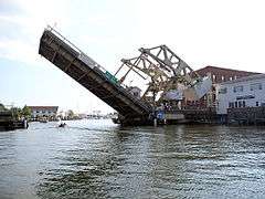
The Mystic Bridge Historic District (also known as Lower Mystic or Mistick) is a historic district on U.S. 1 and CT 27 in the Stonington side of the village of Mystic, Connecticut. The district represents the core of the early settlement of that name on the east bank of the Mystic River. It extends from Washington Street in the south to the Mystic Seaport Museum in the north (whose grounds and floating vessels are included in the district), and from the river (where it includes the 1924 lift bridge) in the west to Denison and Greenmanville Avenues (Connecticut Route 27) on the east. The district is significant as a well-preserved shipbuilding and maritime village of the 19th and early 20th centuries.[2]
The district was added to the National Register of Historic Places in 1979.[1]
See also
- Mystic Seaport, which comprises part of the district
- James M. Hyde, metallurgist, born here
- National Register of Historic Places listings in New London County, Connecticut
- List of bridges on the National Register of Historic Places in Connecticut
References
- 1 2 National Park Service (2009-03-13). "National Register Information System". National Register of Historic Places. National Park Service.
- ↑ David F. Ransom (January 5, 1979). "National Register of Historic Places Inventory – Nomination Form: Mystic Bridge Historic District" (PDF). National Park Service. Retrieved 2016-02-26.
External links
 Media related to Mystic Bridge Historic District at Wikimedia Commons
- Historic American Engineering Record (HAER) No. CT-174, "Mystic River Bridge, Spanning Mystic River at U.S. Route 1, Groton, New London County, CT"