| [3] |
Name on the Register[4] |
Image |
Date listed[5] |
Location |
City or town |
Description |
|---|
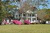
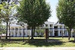
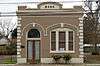
| 1 |
1903 Clinton High School |
|
000000002005-06-01-0000June 1, 2005
(#05000505) |
11050 Bank St.
30°51′44″N 91°01′08″W / 30.862222°N 91.018889°W / 30.862222; -91.018889 (1903 Clinton High School) |
Clinton |
|
| 2 |
1938 Clinton High School |
|
000000002005-06-01-0000June 1, 2005
(#05000506) |
12525 Cedar
30°51′43″N 91°00′49″W / 30.861944°N 91.013611°W / 30.861944; -91.013611 (1938 Clinton High School) |
Clinton |
|
| 3 |
Asphodel Plantation and Cemetery |
Upload image |
000000001972-11-15-0000November 15, 1972
(#72000552) |
South of Jackson on Louisiana Highway 74
30°47′12″N 91°12′57″W / 30.786667°N 91.215833°W / 30.786667; -91.215833 (Asphodel Plantation and Cemetery) |
Jackson |
|
| 4 |
Avondale Plantation Home |
Upload image |
000000001982-12-17-0000December 17, 1982
(#82000434) |
East of Clinton off Louisiana Highway 10
30°51′47″N 90°59′17″W / 30.863056°N 90.988056°W / 30.863056; -90.988056 (Avondale Plantation Home) |
Clinton |
|
| 5 |
Bank of Slaughter |
|
000000002005-05-06-0000May 6, 2005
(#05000369) |
3323 Church St.
30°43′04″N 91°08′41″W / 30.717778°N 91.144722°W / 30.717778; -91.144722 (Bank of Slaughter) |
Slaughter |
|
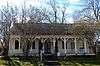
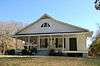
| 6 |
Boatner House |
|
000000001980-05-31-0000May 31, 1980
(#80001719) |
Plank and Taylor Rds.
30°51′49″N 91°00′54″W / 30.863611°N 91.015°W / 30.863611; -91.015 (Boatner House) |
Clinton |
|
| 7 |
Brame-Bennett House |
|
000000001973-05-22-0000May 22, 1973
(#73000866) |
227 S. Baton Rouge St.
30°51′49″N 91°00′56″W / 30.863611°N 91.015556°W / 30.863611; -91.015556 (Brame-Bennett House) |
Clinton |
|
| 8 |
Carroll House |
|
000000001998-06-29-0000June 29, 1998
(#98000679) |
9553 Bank St. Extension
30°50′29″N 91°00′17″W / 30.841389°N 91.004722°W / 30.841389; -91.004722 (Carroll House) |
Clinton |
|
| 9 |
Centenary College |
|
000000001979-04-19-0000April 19, 1979
(#79001062) |
College St.
30°50′33″N 91°12′39″W / 30.8425°N 91.210833°W / 30.8425; -91.210833 (Centenary College) |
Jackson |
|
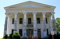
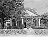
| 10 |
Center Building of East Louisiana State Hospital |
|
000000001980-08-01-0000August 1, 1980
(#80001721) |
East of Jackson on Louisiana Highway 10
30°49′58″N 91°12′51″W / 30.832778°N 91.214167°W / 30.832778; -91.214167 (Center Building of East Louisiana State Hospital) |
Jackson |
|
| 11 |
Clear Creek AME Church |
Upload image |
000000002002-03-28-0000March 28, 2002
(#02000269) |
Approximately ½ mile south of the junction of Louisiana Highways 432 and 961
30°56′12″N 90°52′36″W / 30.936667°N 90.876667°W / 30.936667; -90.876667 (Clear Creek AME Church) |
Felixville |
|
| 12 |
Courthouse and Lawyers' Row |
|
000000001974-05-30-0000May 30, 1974
(#74002249) |
Liberty, St. Helena, Bank, and Woodville Sts.
30°51′58″N 91°01′06″W / 30.8662°N 91.0184°W / 30.8662; -91.0184 (Courthouse and Lawyers' Row) |
Clinton |
|
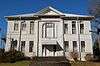
| 13 |
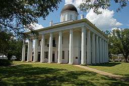
East Feliciana Parish Courthouse |
|
000000001973-06-04-0000June 4, 1973
(#73002232) |
Public Sq.
30°51′57″N 91°01′06″W / 30.865833°N 91.018333°W / 30.865833; -91.018333 (East Feliciana Parish Courthouse) |
Clinton |
|
| 14 |
Fairview Plantation House |
Upload image |
000000001993-08-12-0000August 12, 1993
(#93000821) |
8338 Louisiana Highway 963
30°51′48″N 91°05′31″W / 30.863333°N 91.091944°W / 30.863333; -91.091944 (Fairview Plantation House) |
Ethel |
|
| 15 |
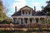
Heyman-Stewart House |
|
000000002001-11-09-0000November 9, 2001
(#01001211) |
10943 Bank St.
30°51′40″N 91°01′06″W / 30.861111°N 91.018333°W / 30.861111; -91.018333 (Heyman-Stewart House) |
Clinton |
|
| 16 |
Holly Grove |
Upload image |
000000001997-02-14-0000February 14, 1997
(#97000058) |
10929 Rouchon Ln.
30°55′42″N 90°56′58″W / 30.928333°N 90.949444°W / 30.928333; -90.949444 (Holly Grove) |
Clinton |
|
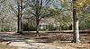
| 17 |
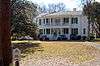
Hope Terrace |
|
000000001986-08-13-0000August 13, 1986
(#86001493) |
Church and Silliman Sts.
30°51′35″N 91°00′58″W / 30.859722°N 91.016111°W / 30.859722; -91.016111 (Hope Terrace) |
Clinton |
|
| 18 |
Jackson Historic District |
|
000000001980-12-04-0000December 4, 1980
(#80001722) |
Roughly bounded by Institute Dr., Louisiana Highway 314, and Horton and Race Sts.
30°50′39″N 91°12′47″W / 30.844167°N 91.213056°W / 30.844167; -91.213056 (Jackson Historic District) |
Jackson |
|
| 19 |
Lane Plantation House |
Upload image |
000000001993-04-22-0000April 22, 1993
(#93000322) |
7684 Lane Ln.
30°48′32″N 91°04′54″W / 30.808889°N 91.081667°W / 30.808889; -91.081667 (Lane Plantation House) |
Ethel |
|
| 20 |
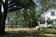
Linwood |
|
000000001980-06-09-0000June 9, 1980
(#80001723) |
7.3 miles south of Jackson
30°43′26″N 91°13′54″W / 30.723889°N 91.231667°W / 30.723889; -91.231667 (Linwood) |
Jackson |
|
| 21 |
Marston House |
|
000000001972-06-29-0000June 29, 1972
(#72000551) |
Bank St.
30°52′00″N 91°01′09″W / 30.866667°N 91.019167°W / 30.866667; -91.019167 (Marston House) |
Clinton |
|
| 22 |
Oakland Plantation House |
Upload image |
000000001980-10-03-0000October 3, 1980
(#80001720) |
West of Gurley
30°52′18″N 91°08′40″W / 30.871667°N 91.144444°W / 30.871667; -91.144444 (Oakland Plantation House) |
Gurley |
|
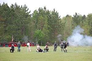
| 23 |
Port Hudson |
|
000000001974-05-30-0000May 30, 1974
(#74002349) |
Port Hudson and environs along U.S. Route 61
30°40′49″N 91°17′11″W / 30.680278°N 91.286389°W / 30.680278; -91.286389 (Port Hudson) |
Port Hudson |
Site of the longest siege in U.S. history, 1863's Siege of Port Hudson during the American Civil War.
|
| 24 |
Richland Plantation |
Upload image |
000000001979-03-28-0000March 28, 1979
(#79001064) |
Southwest of Norwood on Louisiana Highway 442
30°59′32″N 91°01′39″W / 30.992222°N 91.0275°W / 30.992222; -91.0275 (Richland Plantation) |
Norwood |
|
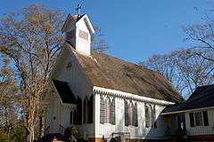
| 25 |
St. Andrew's Episcopal Church |
|
000000001984-06-21-0000June 21, 1984
(#84001282) |
Church and St. Andrew's Sts.
30°51′43″N 91°00′56″W / 30.861944°N 91.015556°W / 30.861944; -91.015556 (St. Andrew's Episcopal Church) |
Clinton |
|
| 26 |
The Shades |
Upload image |
000000001980-11-06-0000November 6, 1980
(#80001724) |
Northeast of Jackson
30°51′47″N 91°10′57″W / 30.863056°N 91.1825°W / 30.863056; -91.1825 (The Shades) |
Jackson |
|
| 27 |
Silliman Institute |
|
000000001983-04-18-0000April 18, 1983
(#83000504) |
Bank St.
30°51′33″N 91°01′13″W / 30.859167°N 91.020278°W / 30.859167; -91.020278 (Silliman Institute) |
Clinton |
|
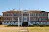
| 28 |
Taylor House |
Upload image |
000000001997-12-08-0000December 8, 1997
(#97001518) |
5000 Louisiana Highway 10
30°50′12″N 91°09′25″W / 30.836667°N 91.156944°W / 30.836667; -91.156944 (Taylor House) |
Jackson |
|
| 29 |
Thompson House |
Upload image |
000000001980-09-29-0000September 29, 1980
(#80001725) |
East of Jackson
30°50′30″N 91°11′13″W / 30.841667°N 91.186944°W / 30.841667; -91.186944 (Thompson House) |
Jackson |
|
| 30 |
Wall House |
Upload image |
000000001984-05-31-0000May 31, 1984
(#84001285) |
Woodville St.
30°52′00″N 91°00′50″W / 30.866667°N 91.013889°W / 30.866667; -91.013889 (Wall House) |
Clinton |
|
| 31 |
Wildwood Plantation House |
Upload image |
000000001988-06-30-0000June 30, 1988
(#88000977) |
Louisiana Highway 68 near U.S. Route 61
30°42′09″N 91°15′39″W / 30.7025°N 91.260833°W / 30.7025; -91.260833 (Wildwood Plantation House) |
Jackson |
|
| 32 |
Woodside |
|
000000001984-10-04-0000October 4, 1984
(#84000012) |
St. Helena St.
30°51′55″N 91°00′58″W / 30.865278°N 91.016111°W / 30.865278; -91.016111 (Woodside) |
Clinton |
|

.jpg)