National Register of Historic Places listings in Murray County, Georgia
This is a list of properties and districts in Murray County, Georgia that are listed on the National Register of Historic Places (NRHP).
- This National Park Service list is complete through NPS recent listings posted December 16, 2016.[1]
Current listings
| [2] | Name on the Register | Image | Date listed[3] | Location | City or town | Description |
|---|---|---|---|---|---|---|
| 1 | Carter's Quarters | Upload image | (#86000460) |
Old U.S. Route 411, 9 miles south of Chatsworth 34°39′27″N 84°42′47″W / 34.6575°N 84.713056°W |
Chatsworth | |
| 2 | Chatsworth Downtown Historic District | 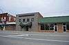 |
(#05000693) |
Roughly bounded by Peachtree St., 1st Ave., CSX railroad tracks, Fort St., and 4th Ave. 34°46′04″N 84°46′06″W / 34.767778°N 84.768333°W |
Chatsworth | |
| 3 | Fort Mountain | 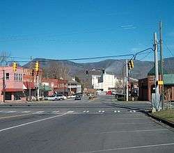 |
(#77001587) |
U.S. Route 76 34°47′03″N 84°42′24″W / 34.784167°N 84.706667°W |
Chatsworth | |
| 4 | Murray County Courthouse | 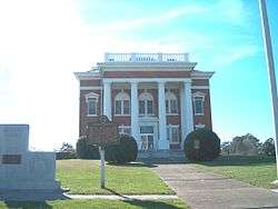 |
(#80001123) |
Courthouse Sq. 34°46′01″N 84°46′14″W / 34.766944°N 84.770556°W |
Chatsworth | |
| 5 | Murray County High School Historic District | Upload image | (#04000628) |
1004 Green St. 34°46′37″N 84°47′20″W / 34.776944°N 84.788889°W |
Chatsworth | |
| 6 | Pleasant Valley Historic District |  |
(#09000751) |
Roughly bounded by the CSX railroad line, the old city limits, and land lot lines 34°50′55″N 84°44′56″W / 34.848611°N 84.748889°W |
Crandall | |
| 7 | Spring Place Historic District | Upload image | (#04000338) |
Approximately 2.5 miles west of Chatsworth, east of the junction of State Routes 52A and 225 34°46′22″N 84°54′42″W / 34.772778°N 84.911667°W |
Spring Place | |
| 8 | Vann House | 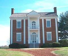 |
(#69000044) |
Junction of U.S. Route 76 and State Route 225 34°45′50″N 84°50′35″W / 34.763889°N 84.843056°W |
Spring Place | A Georgia state historic site |
| 9 | Wright Hotel | .JPG) |
(#82002456) |
201 E. Market St. 34°46′03″N 84°46′06″W / 34.7675°N 84.768333°W |
Chatsworth |
References
| Wikimedia Commons has media related to National Register of Historic Places in Murray County, Georgia. |
- ↑ "National Register of Historic Places: Weekly List Actions". National Park Service, United States Department of the Interior. Retrieved on December 16, 2016.
- ↑ Numbers represent an ordering by significant words. Various colorings, defined here, differentiate National Historic Landmarks and historic districts from other NRHP buildings, structures, sites or objects.
- ↑ The eight-digit number below each date is the number assigned to each location in the National Register Information System database, which can be viewed by clicking the number.
This article is issued from Wikipedia - version of the 6/27/2016. The text is available under the Creative Commons Attribution/Share Alike but additional terms may apply for the media files.