National Register of Historic Places listings in Oglethorpe County, Georgia
This is a list of properties and districts in Oglethorpe County, Georgia that are listed on the National Register of Historic Places (NRHP).
- This National Park Service list is complete through NPS recent listings posted December 16, 2016.[1]
Current listings
| [2] |
Name on the Register |
Image |
Date listed[3] |
Location |
City or town |
Description |
|---|
| 1 |
Amis-Elder House |
Upload image |
000000001978-08-02-0000August 2, 1978
(#78000997) |
W of Crawford on Elder Rd.
33°49′04″N 83°15′55″W / 33.817778°N 83.265278°W / 33.817778; -83.265278 (Amis-Elder House) |
Crawford |
|
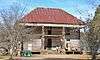
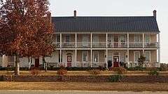
| 2 |
J. L. Bridges Home Place |
Upload image |
000000001978-01-31-0000January 31, 1978
(#78000999) |
N of Lexington on GA 22
33°56′04″N 83°01′28″W / 33.934444°N 83.024444°W / 33.934444; -83.024444 (J. L. Bridges Home Place) |
Lexington |
|
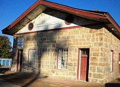
| 3 |
Crawford Depot |
|
000000001977-05-27-0000May 27, 1977
(#77000441) |
U.S. 78
33°52′57″N 83°09′22″W / 33.8825°N 83.156111°W / 33.8825; -83.156111 (Crawford Depot) |
Crawford |
|
| 4 |
Faust Houses and Outbuildings |
Upload image |
000000001980-02-12-0000February 12, 1980
(#80001217) |
NE of Lexington off GA 77
33°53′46″N 83°00′56″W / 33.896111°N 83.015556°W / 33.896111; -83.015556 (Faust Houses and Outbuildings) |
Lexington |
|
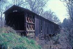
| 5 |
Howard's Covered Bridge |
|
000000001975-07-01-0000July 1, 1975
(#75000604) |
3 mi. SE of Smithonia on SR S2164 over Big Clouds Creek
33°59′09″N 83°08′01″W / 33.985833°N 83.133611°W / 33.985833; -83.133611 (Howard's Covered Bridge) |
Smithonia |
|
| 6 |
Langston-Daniel House |
Upload image |
000000001978-01-31-0000January 31, 1978
(#78000998) |
5 mi. (8 km) W of Crawford on U.S. 78
33°53′45″N 83°13′03″W / 33.895833°N 83.2175°W / 33.895833; -83.2175 (Langston-Daniel House) |
Crawford |
|
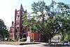
| 7 |
Lexington Historic District |
|
000000001977-04-13-0000April 13, 1977
(#77000442) |
U.S. 78
33°52′16″N 83°06′36″W / 33.871111°N 83.11°W / 33.871111; -83.11 (Lexington Historic District) |
Lexington |
|
| 8 |
Philomath Historic District |
|
000000001979-07-06-0000July 6, 1979
(#79000740) |
GA 22
33°43′19″N 82°59′01″W / 33.721944°N 82.983611°W / 33.721944; -82.983611 (Philomath Historic District) |
Philomath |
|
| 9 |
Smith-Harris House |
Upload image |
000000001985-07-25-0000July 25, 1985
(#85001620) |
CR 207
33°56′57″N 82°57′41″W / 33.949167°N 82.961389°W / 33.949167; -82.961389 (Smith-Harris House) |
Vesta |
|
| 10 |
Smithonia |
|
000000001984-06-21-0000June 21, 1984
(#84001213) |
Address Restricted
|
Comer |
|
| 11 |
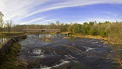
Watson Mill Covered Bridge and Mill Historic District |
|
000000001991-09-05-0000September 5, 1991
(#91001147) |
Along S. Fork Broad R., Watson Mill State Park
34°01′34″N 83°04′23″W / 34.026111°N 83.073056°W / 34.026111; -83.073056 (Watson Mill Covered Bridge and Mill Historic District) |
Comer |
|
References
|
|---|
|
| Topics | |
|---|
|
| Lists by states | |
|---|
|
| Lists by insular areas | |
|---|
|
| Lists by associated states | |
|---|
|
| Other areas | |
|---|
|
-
 Portal Portal
-
 WikiProject WikiProject
|