National Register of Historic Places listings in Pine County, Minnesota

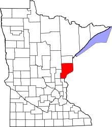
Location of Pine County in Minnesota
This is a list of the National Register of Historic Places listings in Pine County, Minnesota. It is intended to be a complete list of the properties and districts on the National Register of Historic Places in Pine County, Minnesota, United States. The locations of National Register properties and districts for which the latitude and longitude coordinates are included below, may be seen in an online map.
There are 22 properties and districts listed on the National Register in the county, including a National Historic Landmark district. A supplementary list includes two additional sites that were formerly on the National Register.
- This National Park Service list is complete through NPS recent listings posted December 16, 2016.[1]
Current listings
| [2] | Name on the Register | Image | Date listed[3] | Location | City or town | Description |
|---|---|---|---|---|---|---|
| 1 | Bethlehem Lutheran Church |  |
(#80002103) |
Kirke Alle 46°11′17″N 92°46′41″W / 46.188089°N 92.778077°W |
Askov | 1915 brick Gothic Revival church built for a Danish American community.[4] |
| 2 | Cloverton School |  |
(#80002104) |
County Road 32 46°10′03″N 92°19′23″W / 46.167412°N 92.32311°W |
New Dosey Township | 1920 brick school with cast-stone trim.[4] Demolished (see talk page). |
| 3 | District No. 74 School |  |
(#92000820) |
County Highway 22 north of County Highway 30 46°08′35″N 92°38′19″W / 46.143054°N 92.638505°W |
Danforth Township | 1899 log school with 1909 frame addition.[4] |
| 4 | John Doboszenski Farmstead | |
(#80002105) |
Off County Highway 43 46°18′32″N 92°46′12″W / 46.309007°N 92.769966°W |
Willow River vicinity | 1894 farmstead of an immigrant subsistence farmer.[4] |
| 5 | Hinckley Fire Relief House |  |
(#80002112) |
Court Ave. and 6th St. 46°07′58″N 92°51′46″W / 46.132809°N 92.86266°W |
Sandstone | 1894 frame house with lean-to, a surviving example of emergency relief housing built after the Great Hinckley Fire.[4] |
| 6 | Hinckley State Line Marker |  |
(#02000935) |
Minnesota Highway 48 46°00′46″N 92°27′00″W / 46.012703°N 92.450014°W |
Ogema Township | 1942 sandstone National Park Service rustic state entrance sign.[4] |
| 7 | Louis Hultgren House and Sand Pit |  |
(#80002108) |
Minnesota Highway 23 46°20′21″N 92°35′25″W / 46.339167°N 92.590278°W |
Kerrick | c. 1896 house and sand quarrying business of a Swedish immigrant, an example of early industry in the region.[4] |
| 8 | Kettle River Bridge |  |
(#98000687) |
Minnesota Highway 123 over the Kettle River 46°07′44″N 92°51′24″W / 46.128874°N 92.856577°W |
Sandstone | 1948 steel deck truss bridge.[4] |
| 9 | Kettle River Sandstone Company Quarry | |
(#91000877) |
North of Minnesota Highway 123 on the western bank of the Kettle River 46°07′58″N 92°51′28″W / 46.132901°N 92.857666°W |
Sandstone | Site of Minnesota's largest sandstone quarry, active 1885–1919.[4] Now a city park.[5] |
| 10 | Peter P. Kilstofte Farmstead |  |
(#80002109) |
County Highway 33 46°11′50″N 92°47′04″W / 46.197222°N 92.784444°W |
Askov | 1913 dairy farm of a notable contractor, with an American Bungalow farmhouse and a rubble masonry silo.[4] |
| 11 | Minneapolis Trust Company Commercial Building |  |
(#80002113) |
Main and 4th Sts. 46°07′56″N 92°52′00″W / 46.132148°N 92.866686°W |
Sandstone | Commercial building of local sandstone built by company that led reconstruction after the Great Hinckley Fire.[4] Now the Sandstone History and Art Center.[6] |
| 12 | North West Company Post |  |
(#72000679) |
On the Snake River west of Pine City 45°49′17″N 93°00′41″W / 45.821359°N 93.011382°W |
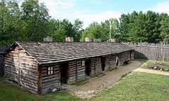
Pine City vicinity | Reconstructed 1804 North West Company fur trading post, now a Minnesota Historical Society living history museum.[7] |
| 13 | Northern Pacific Depot |  |
(#80002107) |
Front St. at Finland Ave. 46°12′02″N 92°54′58″W / 46.200593°N 92.916041°W |
Finlayson | 1909 board-and-batten depot.[4] |
| 14 | Northern Pacific Depot | |
(#73000992) |
Old U.S. Route 61 and 1st St., SE. 46°00′54″N 92°56′36″W / 46.015064°N 92.943401°W |
Hinckley | 1895 reconstruction of frame depot destroyed in the Great Hinckley Fire.[4] Now houses the Hinckley Fire Museum.[8] |
| 15 | John A. Oldenburg House |  |
(#78001556) |
Minnesota Highway 18 46°12′06″N 92°54′53″W / 46.201528°N 92.914803°W |
Finlayson | c. 1896 frame Second Empire house of a prominent businessman.[4] |
| 16 | Partridge Township Hall |  |
(#80002110) |
Kobmagergade 46°11′23″N 92°46′51″W / 46.189587°N 92.780808°W |
Askov | 1901 false-fronted frame community hall.[4] |
| 17 | Red Clover Land Company Demonstration Farm |  |
(#80002106) |
Off County Road 32 46°10′14″N 92°21′02″W / 46.170647°N 92.350426°W |
New Dosey Township | c. 1915 demonstration farm built to show prospective settlers.[4] |
| 18 | St. Croix Recreational Demonstration Area |  |
(#96001594) |
Off Minnesota Highway 48 along the St. Croix National Scenic Riverway in Clover, Ogema, Crosby, Munch, and Chengwatana Townships 45°57′03″N 92°34′12″W / 45.950717°N 92.570128°W |
Hinckley vicinity | Recreation Demonstration Area developed 1934–1943 by the CCC and WPA to repurpose poor farmland.[9] Contains 164 National Park Service rustic structures, the largest collection in Minnesota.[10] |
| 19 | Sandstone School |  |
(#79001251) |
Commercial Ave. between 5th and 6th Sts. 46°07′58″N 92°51′50″W / 46.132715°N 92.863854°W |
Sandstone | 1901 Romanesque/Classical Revival school of local sandstone, with 1910 addition.[4] |
| 20 | Arnold Schwyzer Summer House and Farmstead |  |
(#80002114) |
County Road 17 46°07′12″N 93°00′07″W / 46.119957°N 93.001907°W |
Sandstone vicinity | Summer home and dairy farm developed 1902–1920s, example of the private lake retreats built in Pine County by affluent urbanites.[11] Now the Audubon Center of the North Woods.[12] |
| 21 | Stumne Mounds | |
(#72000680) |
Address Restricted |
Pine City vicinity | Linear and conical mounds dating to c. 600 CE.[4] |
| 22 | Willow River Rutabaga Warehouse and Processing Plant |  |
(#90000935) |
Off County Highway 61 46°19′08″N 92°50′27″W / 46.318855°N 92.840851°W |
Willow River | 1935 processing and storage center for rutabagas, Minnesota's only handling facility specific to this local cash crop.[4] |
Former listings
| [2] | Name on the Register | Image | Date listed | Date removed | Location | City or town | Summary |
|---|---|---|---|---|---|---|---|
| 1 | Bridge No. 1811 over Kettle River | Upload image | (#98001107) | Co. Hwy 33 over Kettle River |
Rutledge vicinity | 1916 Pratt truss bridge.[4] Demolished in 2004.[13] | |
| 2 | Pine City Naval Militia Armory | Upload image | (#80002111) | 1st Avenue |
Pine City | 1914 armory.[14] Demolished in 2000.[4] |
See also
- List of National Historic Landmarks in Minnesota
- National Register of Historic Places listings in Minnesota
References
- ↑ "National Register of Historic Places: Weekly List Actions". National Park Service, United States Department of the Interior. Retrieved on December 16, 2016.
- 1 2 Numbers represent an ordering by significant words. Various colorings, defined here, differentiate National Historic Landmarks and historic districts from other NRHP buildings, structures, sites or objects.
- ↑ The eight-digit number below each date is the number assigned to each location in the National Register Information System database, which can be viewed by clicking the number.
- 1 2 3 4 5 6 7 8 9 10 11 12 13 14 15 16 17 18 19 20 21 Nord, Mary Ann (2003). The National Register of Historic Places in Minnesota. Minnesota Historical Society. ISBN 0-87351-448-3.
- ↑ "Robinson Park". City of Sandstone. Retrieved 2013-03-07.
- ↑ City of Sandstone. "Sandstone History and Art Center". Things to do/ Places to see. Retrieved 2013-08-18.
- ↑ "North West Company Post". Minnesota Historical Society. Retrieved 2012-10-01.
- ↑ "Hinckley Fire Museum: Railroading". Hinckley Fire Museum. Retrieved 2012-10-02.
- ↑ "St. Croix Recreational Demonstration Area". National Historic Landmarks Program. National Park Service. Retrieved 2012-10-01.
- ↑ Benson, David R. (2002). Stories in Log and Stone: The Legacy of the New Deal in Minnesota State Parks. St. Paul, Minn.: Minnesota Department of Natural Resources. ISBN 0-9657127-1-0.
- ↑ Haidet, Mark (March 1980). "National Register of Historic Places Registration Form: Schwyzer Farmstead" (PDF). National Park Service. Retrieved 2013-06-10.
- ↑ "Audubon Center of the North Woods". 2013-06-03. Retrieved 2013-06-10.
- ↑ "Changes to the National Register of Historic Places in Minnesota, 2003-2010". Minnesota State Historic Preservation Office. 2011-02-01. Retrieved 2012-10-01.
- ↑ "Pine City Naval Militia Armory (removed)". Minnesota National Register Properties Database. Minnesota Historical Society. 2009. Retrieved 2013-03-07.
External links
| Wikimedia Commons has media related to National Register of Historic Places in Pine County, Minnesota. |
- Minnesota National Register Properties Database—Minnesota Historical Society
This article is issued from Wikipedia - version of the 6/3/2016. The text is available under the Creative Commons Attribution/Share Alike but additional terms may apply for the media files.