| [3] |
Name on the Register[4] |
Image |
Date listed[5] |
Location |
City or town |
Description |
|---|
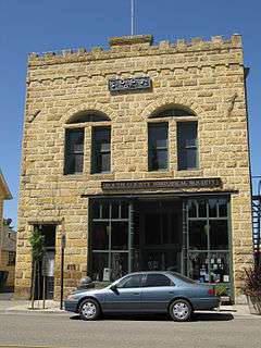
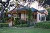
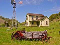
| 1 |
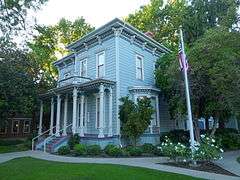
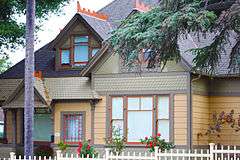
Administration Building, Atascadero Colony |
|
000000001977-11-17-0000November 17, 1977
(#77000336) |
6500 Palma Ave.
35°29′23″N 120°39′58″W / 35.489722°N 120.666111°W / 35.489722; -120.666111 (Administration Building, Atascadero Colony) |
Atascadero |
|
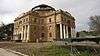
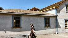
| 2 |
Ah Louis Store |
|
000000002008-03-26-0000March 26, 2008
(#08000203) |
800 Palm St.
35°16′58″N 120°39′49″W / 35.282778°N 120.663611°W / 35.282778; -120.663611 (Ah Louis Store) |
San Luis Obispo |
|
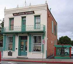
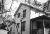
| 3 |
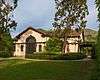
Myron Angel House |
|
000000001982-11-22-0000November 22, 1982
(#82000988) |
714 Buchon St.
35°16′33″N 120°39′39″W / 35.275833°N 120.660833°W / 35.275833; -120.660833 (Myron Angel House) |
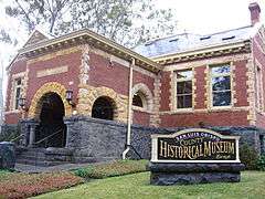
San Luis Obispo |
|
| 4 |
Archeological Site 4 SLO 834 |
Upload image |
000000001982-02-25-0000February 25, 1982
(#82004618) |
Address Restricted
|
Atascadero |
|
| 5 |
Arroyo Grande IOOF Hall |
|
000000001991-03-22-0000March 22, 1991
(#91000344) |
128 Bridge St.
35°07′20″N 120°34′38″W / 35.122222°N 120.577222°W / 35.122222; -120.577222 (Arroyo Grande IOOF Hall) |
Arroyo Grande |
|
| 6 |
Atascadero Printery |
|
000000002004-01-02-0000January 2, 2004
(#00001368) |
6351 Olmeda
35°29′32″N 120°39′56″W / 35.492222°N 120.665556°W / 35.492222; -120.665556 (Atascadero Printery) |
Atascadero |
|
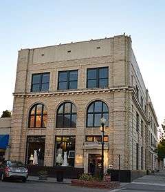
| 7 |
Bank of Italy |
|
000000001998-03-19-0000March 19, 1998
(#98000245) |
1245 Park St.
35°37′39″N 120°41′21″W / 35.6275°N 120.689167°W / 35.6275; -120.689167 (Bank of Italy) |
Paso Robles |
|
| 8 |
Brewster-Dutra House |
Upload image |
000000001982-10-29-0000October 29, 1982
(#82000989) |
1803 Vine St.
35°37′59″N 120°41′37″W / 35.633056°N 120.693611°W / 35.633056; -120.693611 (Brewster-Dutra House) |
Paso Robles |
|
| 9 |
Caledonia Adobe |
|
000000001971-07-14-0000July 14, 1971
(#71000190) |
0.5 mi. S of 10th St.
35°44′17″N 120°41′56″W / 35.738056°N 120.698889°W / 35.738056; -120.698889 (Caledonia Adobe) |
San Miguel |
|
| 10 |
Call-Booth House |
|
000000001988-11-03-0000November 3, 1988
(#88002031) |
1315 Vine St.
35°37′40″N 120°41′35″W / 35.627778°N 120.693056°W / 35.627778; -120.693056 (Call-Booth House) |
Paso Robles |
|
| 11 |
Carrizo Plain Rock Art Discontiguous District |
|
000000002001-05-23-0000May 23, 2001
(#01000509) |
Address Restricted
|
California Valley |
designated the Carrizo Plain Archeological District National Historic Landmark District 000000002012-03-02-0000March 2, 2012
|
| 12 |
Corral de Piedra |
|
000000001978-05-22-0000May 22, 1978
(#78000766) |
S of San Luis Obispo on Price Canyon Rd.
35°11′37″N 120°37′28″W / 35.193611°N 120.624444°W / 35.193611; -120.624444 (Corral de Piedra) |
San Luis Obispo |
|
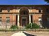
| 13 |
Dana Adobe |
|
000000001971-05-06-0000May 6, 1971
(#71000189) |
S end of Oak Glen Ave.
35°01′40″N 120°31′40″W / 35.027778°N 120.527778°W / 35.027778; -120.527778 (Dana Adobe) |
Nipomo |
|
| 14 |
Eight Mile House |
|
000000001995-03-31-0000March 31, 1995
(#95000358) |
Off CA 101 on Stagecoach Rd.
35°22′02″N 120°38′17″W / 35.367222°N 120.638056°W / 35.367222; -120.638056 (Eight Mile House) |
Santa Margarita |
|
| 15 |
Guthrie House |
Upload image |
000000001980-01-10-0000January 10, 1980
(#80000853) |
Burton and Center Sts.
35°33′49″N 121°04′52″W / 35.563611°N 121.081111°W / 35.563611; -121.081111 (Guthrie House) |
Cambria |
|
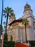
| 16 |
Hearst San Simeon Estate |
|
000000001972-06-22-0000June 22, 1972
(#72000253) |
3 mi. NE of San Simeon
35°41′06″N 121°10′07″W / 35.685°N 121.168611°W / 35.685; -121.168611 (Hearst San Simeon Estate) |
San Simeon |
|
| 17 |
Robert Jack House |
|
000000001992-04-13-0000April 13, 1992
(#92000312) |
536 Marsh St.
35°16′38″N 120°39′53″W / 35.277222°N 120.664722°W / 35.277222; -120.664722 (Robert Jack House) |
San Luis Obispo |
|
| 18 |
Lincoln School |
Upload image |
000000002001-11-21-0000November 21, 2001
(#01001244) |
9000 Chimney Rock Rd.
35°40′05″N 120°51′18″W / 35.668056°N 120.855°W / 35.668056; -120.855 (Lincoln School) |
Paso Robles |
|
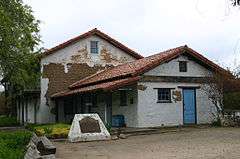
| 19 |
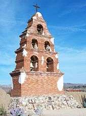
Mission San Miguel Arcangel |
|
000000001971-07-14-0000July 14, 1971
(#71000191) |
801 Mission Street (old CA 101)
35°37′59″N 120°41′37″W / 35.633056°N 120.693611°W / 35.633056; -120.693611 (Mission San Miguel Arcangel) |
San Miguel |
|
| 20 |
Monday Club of San Luis Obispo |
|
000000002016-05-10-0000May 10, 2016
(#16000230) |
1815 Monterey St.
35°17′19″N 120°39′05″W / 35.288551°N 120.651366°W / 35.288551; -120.651366 (Monday Club of San Luis Obispo) |
San Luis Obispo |
|
| 21 |
MONTEBELLO (shipwreck and remains) |
Upload image |
000000002916-09-27-0000September 27, 2916
(#16000636) |
Off the coast
35°35′00″N 121°16′00″W / 35.583333°N 121.266667°W / 35.583333; -121.266667 (MONTEBELLO (shipwreck and remains)) |
Cambria vicinity |
|
| 22 |
Morro Bay State Park Trailer and Tent Campground |
Upload image |
000000002014-10-15-0000October 15, 2014
(#14000852) |
20 State Park Rd.
35°20′49″N 120°50′19″W / 35.34692°N 120.838677°W / 35.34692; -120.838677 (Morro Bay State Park Trailer and Tent Campground) |
Morro Bay |
|
| 23 |
Old Santa Rosa Catholic Church and Cemetery |
Upload image |
000000001982-10-29-0000October 29, 1982
(#82000990) |
Main St.
35°33′58″N 121°04′48″W / 35.566111°N 121.08°W / 35.566111; -121.08 (Old Santa Rosa Catholic Church and Cemetery) |
Cambria |
|
| 24 |
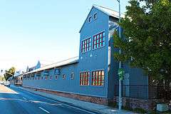
Pacific Coast Railway Company Grain Warehouse |
|
000000001988-06-23-0000June 23, 1988
(#88000921) |
65 Higuera St.
35°16′22″N 120°39′54″W / 35.272778°N 120.665°W / 35.272778; -120.665 (Pacific Coast Railway Company Grain Warehouse) |
San Luis Obispo |
|
| 25 |
Paso Robles Almond Growers Association Warehouse |
Upload image |
000000002016-03-22-0000March 22, 2016
(#16000095) |
525 Riverside Ave.
35°37′13″N 120°41′13″W / 35.620182°N 120.686836°W / 35.620182; -120.686836 (Paso Robles Almond Growers Association Warehouse) |
Paso Robles |
|
| 26 |
Paso Robles Carnegie Library |
|
000000001998-01-26-0000January 26, 1998
(#97001635) |
City Park, 800 12th St.
35°37′33″N 120°41′20″W / 35.625833°N 120.688889°W / 35.625833; -120.688889 (Paso Robles Carnegie Library) |
Paso Robles |
|
| 27 |
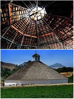
Pereira Octagon Barn |
|
000000002014-01-15-0000January 15, 2014
(#13001068) |
4400 Octagon Wy.
35°14′13″N 120°40′47″W / 35.236927°N 120.679602°W / 35.236927; -120.679602 (Pereira Octagon Barn) |
San Luis Obispo |
|
| 28 |
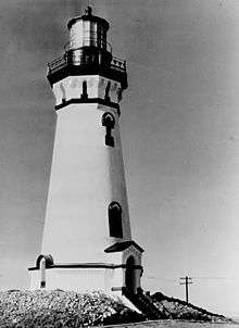
Piedras Blancas Light Station |
|
000000001991-09-03-0000September 3, 1991
(#91001095) |
CA 1 on Point Piedras Blancas
35°39′57″N 121°17′02″W / 35.665833°N 121.283889°W / 35.665833; -121.283889 (Piedras Blancas Light Station) |
San Simeon |
|
| 29 |
Port San Luis Site |
|
000000001978-05-22-0000May 22, 1978
(#78000767) |
Address Restricted
|
San Luis Obispo |
|
| 30 |
The Powerhouse |
|
000000001993-07-30-0000July 30, 1993
(#93000670) |
Jct. of S. Perimeter Rd. and Cuesta Ave., NE corner
35°17′57″N 120°39′45″W / 35.299167°N 120.6625°W / 35.299167; -120.6625 (The Powerhouse) |
San Luis Obispo |
|
| 31 |
John Price House |
|
000000001988-11-03-0000November 3, 1988
(#88002013) |
Highland Dr. off Price Canyon Rd.
35°08′52″N 120°38′20″W / 35.147778°N 120.638889°W / 35.147778; -120.638889 (John Price House) |
Pismo Beach |
|
| 32 |
Rancho Canada de los Osos y Pecho y Islay |
|
000000001975-06-20-0000June 20, 1975
(#75000477) |
Address Restricted
|
Los Osos |
|
| 33 |
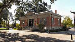
San Luis Obispo Carnegie Library |
|
000000001995-03-30-0000March 30, 1995
(#95000357) |
696 Monterey St.
35°16′49″N 120°39′50″W / 35.280278°N 120.663889°W / 35.280278; -120.663889 (San Luis Obispo Carnegie Library) |
San Luis Obispo |
|
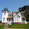
| 34 |
San Luis Obispo Light Station |
|
000000001991-09-03-0000September 3, 1991
(#91001093) |
Point San Luis
35°09′42″N 120°45′26″W / 35.161667°N 120.757222°W / 35.161667; -120.757222 (San Luis Obispo Light Station) |
Avila Beach |
|
| 35 |
William Shipsey House |
|
000000002010-03-31-0000March 31, 2010
(#10000115) |
1266 Mill St.
35°17′09″N 120°39′32″W / 35.285797°N 120.658967°W / 35.285797; -120.658967 (William Shipsey House) |
San Luis Obispo |
|
| 36 |
Tribune-Republic Building |
|
000000001993-06-24-0000June 24, 1993
(#93000548) |
1763 Santa Barbara St.
35°16′33″N 120°39′21″W / 35.275833°N 120.655833°W / 35.275833; -120.655833 (Tribune-Republic Building) |
San Luis Obispo |
|