| [3] |
Name on the Register[4] |
Image |
Date listed[5] |
Location |
City or town |
Description |
|---|
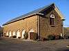
| 1 |
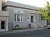
Benicia Arsenal |
|
000000001976-11-07-0000November 7, 1976
(#76000534) |
Army Point and I-680
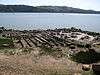
38°03′12″N 122°08′03″W / 38.053439°N 122.134218°W / 38.053439; -122.134218 (Benicia Arsenal) |
Benicia |
|
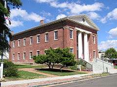
| 2 |
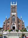
Benicia Capitol State Historic Park |
|
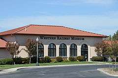
000000001971-02-12-0000February 12, 1971
(#71000204) |
1st and G Sts.
38°03′00″N 122°09′32″W / 38.050077°N 122.158808°W / 38.050077; -122.158808 (Benicia Capitol State Historic Park) |
Benicia |
|
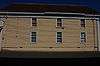
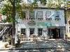
| 3 |
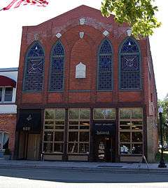
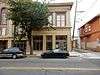
Bird and Dinkelspiel Store |
|
000000001999-10-21-0000October 21, 1999
(#99001264) |
2145 Collinsville Rd.
38°07′58″N 121°52′16″W / 38.132793°N 121.871157°W / 38.132793; -121.871157 (Bird and Dinkelspiel Store) |
Birds Landing |
General store built in 1875.
|
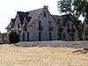
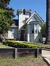
| 4 |
Jackson Fay Brown House |
|
000000002002-11-07-0000November 7, 2002
(#02001289) |
6751 Maine Prairie Rd.
38°19′59″N 121°48′50″W / 38.333056°N 121.813889°W / 38.333056; -121.813889 (Jackson Fay Brown House) |
Dixon |
|
| 5 |
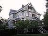
Will H. Buck House |
|
000000001985-10-24-0000October 24, 1985
(#85003372) |
301 Buck Ave.
38°21′23″N 121°59′42″W / 38.356512°N 121.995096°W / 38.356512; -121.995096 (Will H. Buck House) |
Vacaville |
|
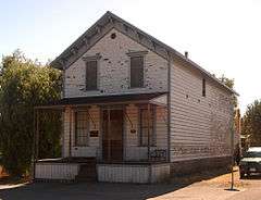
| 6 |
Carr House |
|
000000001979-09-13-0000September 13, 1979
(#79000555) |
165 E. D St
38°02′48″N 122°09′32″W / 38.04679°N 122.158872°W / 38.04679; -122.158872 (Carr House) |
Benicia |
demolished circa 2000[6]
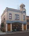
|
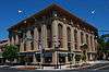
| 7 |
City Hall |
|
000000002013-08-13-0000August 13, 2013
(#13000591) |
715 Marin St.
38°06′09″N 122°15′25″W / 38.102574°N 122.256807°W / 38.102574; -122.256807 (City Hall) |
Vallejo |
|
| 8 |
Crooks Mansion |
|
000000001978-11-14-0000November 14, 1978
(#78000795) |
285 W. G St.
38°03′06″N 122°09′44″W / 38.051798°N 122.162173°W / 38.051798; -122.162173 (Crooks Mansion) |
Benicia |
|
| 9 |
Dixon Carnegie Library |
|
000000002011-02-04-0000February 4, 2011
(#10001199) |
135 E. B St.
38°26′48″N 121°49′20″W / 38.446667°N 121.822222°W / 38.446667; -121.822222 (Dixon Carnegie Library) |
Dixon |
California Carnegie Libraries MPS
|
| 10 |
Joseph Fischer House |
|
000000001979-05-24-0000May 24, 1979
(#79000556) |
135 G St.
38°03′01″N 122°09′34″W / 38.050262°N 122.159345°W / 38.050262; -122.159345 (Joseph Fischer House) |
Benicia |
|
| 11 |
Daniel Webster Harrier House |
Upload image |
000000002015-12-08-0000December 8, 2015
(#15000860) |
739 Ohio St.
38°06′25″N 122°15′13″W / 38.1070°N 122.253585°W / 38.1070; -122.253585 (Daniel Webster Harrier House) |
Vallejo |
|
| 12 |
Hastings Adobe |
|
000000001972-06-13-0000June 13, 1972
(#72000260) |
Northeast of Collinsville off CA 68
38°04′35″N 121°49′54″W / 38.076516°N 121.83174°W / 38.076516; -121.83174 (Hastings Adobe) |
Collinsville |
|
| 13 |
LCS-102 (landing craft support) |
|
000000002015-10-13-0000October 13, 2015
(#15000716) |
7th & Nimitz Sts., Mare Island
38°06′05″N 122°16′11″W / 38.1015°N 122.2698°W / 38.1015; -122.2698 (LCS-102 (landing craft support)) |
Vallejo |
|
| 14 |
Mare Island Naval Shipyard |
|
000000001975-05-15-0000May 15, 1975
(#75002103) |
Mare Island
38°05′24″N 122°15′48″W / 38.09°N 122.263333°W / 38.09; -122.263333 (Mare Island Naval Shipyard) |
Vallejo |
Boundary increase (added January 21, 1997): Mare Island Historic District, Vallejo, California
|
| 15 |
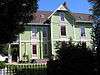
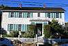
Samuel Martin House |
|
000000001977-05-26-0000May 26, 1977
(#77000349) |
293 Suisun Valley Rd.
38°14′08″N 122°07′35″W / 38.235686°N 122.126418°W / 38.235686; -122.126418 (Samuel Martin House) |
Suisun City |
1861 home of early Solano County settler; also known as Stonedene
|
| 16 |
Masonic Temple-Naval Lodge No. 87, Free and Accepted Masons |
|
000000002013-08-07-0000August 7, 2013
(#13000575) |
707 Marin St.
38°06′08″N 122°15′25″W / 38.102351°N 122.256817°W / 38.102351; -122.256817 (Masonic Temple-Naval Lodge No. 87, Free and Accepted Masons) |
Vallejo |
|
| 17 |
Old Masonic Hall |
|
000000001972-03-16-0000March 16, 1972
(#72000259) |
106 W. J St.
38°03′08″N 122°09′27″W / 38.052357°N 122.157423°W / 38.052357; -122.157423 (Old Masonic Hall) |
Benicia |
|
| 18 |
Pena Adobe |
|
000000001972-01-07-0000January 7, 1972
(#72000261) |
2 miles (3.2 km) southwest of Vacaville on I-80
38°20′11″N 122°00′54″W / 38.336262°N 122.014992°W / 38.336262; -122.014992 (Pena Adobe) |
Vacaville |
|
| 19 |
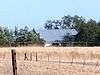
Pleasants Ranch |
Upload image |
000000002006-04-07-0000April 7, 2006
(#06000280) |
8212 Pleasants Valley Rd.
38°27′50″N 122°03′00″W / 38.463813°N 122.049868°W / 38.463813; -122.049868 (Pleasants Ranch) |
Vacaville |
|
| 20 |
Sacramento Northern Railway Historic District |
|
000000002012-07-11-0000July 11, 2012
(#12000402) |
5848 State Highway 12
38°12′14″N 121°52′31″W / 38.20395°N 121.875384°W / 38.20395; -121.875384 (Sacramento Northern Railway Historic District) |
Suisun City |
|
| 21 |
Saint Vincent's Hill Historic District |
|
000000002003-11-21-0000November 21, 2003
(#03001168) |
Roughly bounded by Mare Island Way almost to Sonoma Blvd. and from Quincy Alley to Kissel Alley
38°06′20″N 122°15′30″W / 38.105556°N 122.258333°W / 38.105556; -122.258333 (Saint Vincent's Hill Historic District) |
Vallejo |
|
| 22 |
STAMBOUL (Whaling Bark) |
|
000000001988-11-02-0000November 2, 1988
(#88002030) |
Foot of W. 12th St.
38°03′44″N 122°10′47″W / 38.062149°N 122.179606°W / 38.062149; -122.179606 (STAMBOUL (Whaling Bark)) |
Benicia |
|
| 23 |
Suisun Masonic Lodge No. 55 |
|
000000001978-12-18-0000December 18, 1978
(#78000798) |
623 Main St.
38°14′19″N 122°02′27″W / 38.238601°N 122.040705°W / 38.238601; -122.040705 (Suisun Masonic Lodge No. 55) |
Suisun City |
|
| 24 |
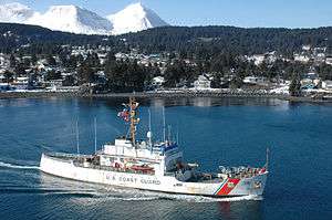
USCGC STORIS (cutter) |
|
000000002012-12-31-0000December 31, 2012
(#12001110) |
U.S. Maritime Administration National Defense Reserve Fleet, Suisun Bay
38°05′05″N 122°05′04″W / 38.084594°N 122.084322°W / 38.084594; -122.084322 (USCGC STORIS (cutter)) |
Benicia |
|
| 25 |
Vacaville Town Hall |
|
000000001978-09-18-0000September 18, 1978
(#78000799) |
620 E. Main St.
38°21′23″N 121°59′09″W / 38.356356°N 121.985881°W / 38.356356; -121.985881 (Vacaville Town Hall) |
Vacaville |
|
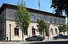
| 26 |
Vallejo City Hall and County Building Branch |
|
000000001976-11-07-0000November 7, 1976
(#76000535) |
734 Marin St.
38°06′10″N 122°15′23″W / 38.102811°N 122.256451°W / 38.102811; -122.256451 (Vallejo City Hall and County Building Branch) |
Vallejo |
|
| 27 |
Vallejo Old City Historic District |
|
000000001973-03-20-0000March 20, 1973
(#73000460) |
Sonoma Blvd., and Monterey, Carolina, and York Sts.
38°06′07″N 122°14′59″W / 38.101944°N 122.249722°W / 38.101944; -122.249722 (Vallejo Old City Historic District) |
Vallejo |
|
| 28 |
Von Pfister General Store |
|
000000002015-06-24-0000June 24, 2015
(#15000360) |
Von Pfister Alley (waterfront between C and D Streets)
38°02′50″N 122°09′41″W / 38.047159°N 122.161309°W / 38.047159; -122.161309 (Von Pfister General Store) |
Benicia |
|

_102.jpg)
_1945.jpg)