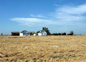
| [3] |
Name on the Register[4] |
Image |
Date listed[5] |
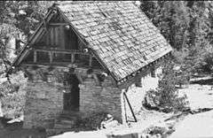
Location |
City or town |
Description |
|---|
| 1 |
Allensworth Historic District |
|
000000001972-02-23-0000February 23, 1972
(#72000263) |
Town of Allensworth and its environs along CA 43
35°51′45″N 119°23′12″W / 35.8625°N 119.386667°W / 35.8625; -119.386667 (Allensworth Historic District) |
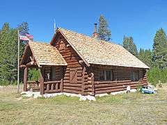
Allensworth |
|
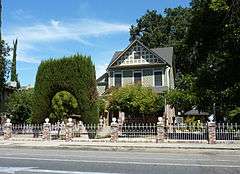
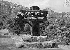
| 2 |
Ash Mountain Entrance Sign |
|
000000001978-04-27-0000April 27, 1978
(#78000367) |
N of Three Rivers in Sequoia National Park
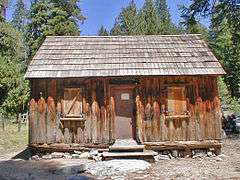
36°29′15″N 118°50′09″W / 36.4875°N 118.835833°W / 36.4875; -118.835833 (Ash Mountain Entrance Sign) |
Three Rivers |
|
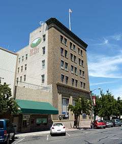
| 3 |
Bank of Italy Building |
|
000000001982-04-01-0000April 1, 1982
(#82002280) |
128 E. Main St.
36°19′49″N 119°17′16″W / 36.330278°N 119.287778°W / 36.330278; -119.287778 (Bank of Italy Building) |
Visalia |
|
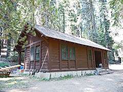
| 4 |
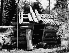
Barton-Lackey Cabin |
|
000000001978-03-30-0000March 30, 1978
(#78000290) |
N of Mineral King in Kings Canyon National Park
36°42′46″N 118°34′59″W / 36.712778°N 118.583056°W / 36.712778; -118.583056 (Barton-Lackey Cabin) |
Mineral King |
|
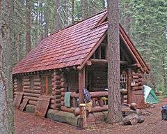
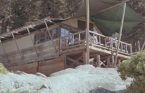
| 5 |
Bearpaw High Sierra Camp |
|
000000002016-04-21-0000April 21, 2016
(#16000192) |
Along High Sierra Trail, 11 mi. East of Crescent Meadow, Sequoia National Park
36°33′54″N 118°37′17″W / 36.565028°N 118.621276°W / 36.565028; -118.621276 (Bearpaw High Sierra Camp) |
Three Rivers |
|
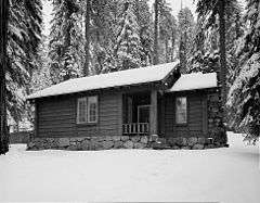
| 6 |
Cabin Creek Ranger Residence and Dormitory |
|
000000001978-04-27-0000April 27, 1978
(#78000368) |
SE of Wilsonia on Generals Highway in Sequoia National Park
36°38′56″N 118°48′49″W / 36.648889°N 118.813611°W / 36.648889; -118.813611 (Cabin Creek Ranger Residence and Dormitory) |
Wilsonia |
|
| 7 |
Cattle Cabin |
|
000000001977-09-15-0000September 15, 1977
(#77000150) |
NE of Three Rivers on Sequoia National Park
36°34′18″N 118°45′11″W / 36.571667°N 118.753056°W / 36.571667; -118.753056 (Cattle Cabin) |
Three Rivers |
|
| 8 |
C. A. Elster Building |
Upload image |
000000001982-03-25-0000March 25, 1982
(#82002279) |
CA 190 and Tule River Dr.
36°07′50″N 118°48′59″W / 36.130556°N 118.816389°W / 36.130556; -118.816389 (C. A. Elster Building) |
Springville |
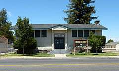
|
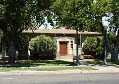
| 9 |
Exeter Public Library |
|
000000001990-12-10-0000December 10, 1990
(#90001811) |
309 S. E St.
36°17′36″N 119°08′17″W / 36.293333°N 119.138056°W / 36.293333; -119.138056 (Exeter Public Library) |
Exeter |
|
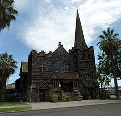
| 10 |
First Congregational Church |
|
000000001999-01-05-0000January 5, 1999
(#98001553) |
165 E. Mill St.
36°04′07″N 119°00′43″W / 36.068611°N 119.011944°W / 36.068611; -119.011944 (First Congregational Church) |
Porterville |
|
| 11 |
Generals' Highway Stone Bridges |
|
000000001978-09-13-0000September 13, 1978
(#78000284) |
N of Mineral King in Sequoia National Park
36°36′27″N 118°44′46″W / 36.6075°N 118.746111°W / 36.6075; -118.746111 (Generals' Highway Stone Bridges) |
Mineral King |
|
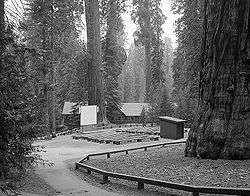
| 12 |
Giant Forest Lodge Historic District |
|
000000001978-05-05-0000May 5, 1978
(#78000287) |
NE of Three Rivers in Sequoia National Park
36°33′56″N 118°45′58″W / 36.565556°N 118.766111°W / 36.565556; -118.766111 (Giant Forest Lodge Historic District) |
Three Rivers |
|
| 13 |
Giant Forest Village-Camp Kaweah Historic District |
|
000000001978-05-22-0000May 22, 1978
(#78000311) |
N of Three Rivers in Sequoia National Park
36°33′52″N 118°46′24″W / 36.564444°N 118.773333°W / 36.564444; -118.773333 (Giant Forest Village-Camp Kaweah Historic District) |
Three Rivers |
|
| 14 |
Groenfeldt Site |
Upload image |
000000001978-03-30-0000March 30, 1978
(#78000288) |
Address Restricted
|
Three Rivers |
|
| 15 |
Hockett Meadow Ranger Station |
|
000000001978-04-27-0000April 27, 1978
(#78000369) |
S of Silver City in Sequoia National Park
36°22′37″N 118°39′19″W / 36.376944°N 118.655278°W / 36.376944; -118.655278 (Hockett Meadow Ranger Station) |
Silver City |
|
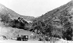
| 16 |
Hospital Rock |
|
000000001977-08-29-0000August 29, 1977
(#77000122) |
Address Restricted
|
Three Rivers |
|
| 17 |
Hyde House |
|
000000001979-04-26-0000April 26, 1979
(#79000565) |
500 S. Court St.
36°19′33″N 119°17′28″W / 36.325833°N 119.291111°W / 36.325833; -119.291111 (Hyde House) |
Visalia |
|
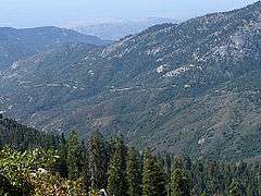
| 18 |
Mineral King Road Cultural Landscape |
|
000000002003-10-24-0000October 24, 2003
(#03001063) |
Mineral King Rd, Sequoia National Park
Coordinates missing |
Mineral King |
|
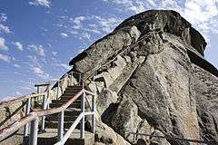
| 19 |
Moro Rock Stairway |
|
000000001978-12-29-0000December 29, 1978
(#78000283) |
N of Three Rivers in Sequoia National Park
36°32′39″N 118°45′51″W / 36.544167°N 118.764167°W / 36.544167; -118.764167 (Moro Rock Stairway) |
Three Rivers |
|
| 20 |
Orosi Branch Library |
|
000000001983-08-25-0000August 25, 1983
(#83001247) |
12662 Ave. 416
36°32′42″N 119°17′22″W / 36.545°N 119.289444°W / 36.545; -119.289444 (Orosi Branch Library) |
Orosi |
|
| 21 |
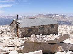
Pear Lake Ski Hut |
|
000000001978-05-05-0000May 5, 1978
(#78000285) |
N of Mineral King on Sequoia National Park
36°36′29″N 118°40′15″W / 36.608056°N 118.670833°W / 36.608056; -118.670833 (Pear Lake Ski Hut) |
Mineral King |
|
| 22 |
Pogue Hotel |
Upload image |
000000001991-08-05-0000August 5, 1991
(#91000927) |
32792 Sierra Dr. (CA 198)
36°22′58″N 119°01′25″W / 36.382778°N 119.023611°W / 36.382778; -119.023611 (Pogue Hotel) |
Lemon Cove |
|
| 23 |
Quinn Ranger Station |
|
000000001977-04-13-0000April 13, 1977
(#77000118) |
S on Mineral King on Sequoia National Park
36°19′29″N 118°34′33″W / 36.324722°N 118.575833°W / 36.324722; -118.575833 (Quinn Ranger Station) |
Mineral King |
|
| 24 |
Redwood Meadow Ranger Station |
|
000000001978-04-13-0000April 13, 1978
(#78000289) |
NE of Three Rivers in Sequoia National Park
36°31′46″N 118°38′07″W / 36.529444°N 118.635278°W / 36.529444; -118.635278 (Redwood Meadow Ranger Station) |
Three Rivers |
|
| 25 |
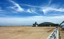
Sequoia Field- Visalia-Dinuba School of Aeronautics |
|
000000002000-06-09-0000June 9, 2000
(#99001591) |
Near jct. of Ave. 368 and Road 112, 9 mi (14 km). N of Visalia
36°26′51″N 119°19′15″W / 36.4475°N 119.320833°W / 36.4475; -119.320833 (Sequoia Field- Visalia-Dinuba School of Aeronautics) |
Visalia |
|
| 26 |
Shorty Lovelace Historic District |
|
000000001978-01-31-0000January 31, 1978
(#78000293) |
E of Pinehurst on Kings Canyon National Park
36°44′26″N 118°31′03″W / 36.740556°N 118.5175°W / 36.740556; -118.5175 (Shorty Lovelace Historic District) |
Pinehurst |
|
| 27 |
Smithsonian Institution Shelter |
|
000000001977-03-08-0000March 8, 1977
(#77000119) |
W of Lone Pine in Sequoia National Park
36°34′49″N 118°17′32″W / 36.580278°N 118.292222°W / 36.580278; -118.292222 (Smithsonian Institution Shelter) |
Lone Pine |
|
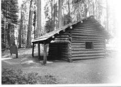
| 28 |
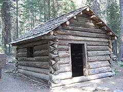
Squatter's Cabin |
|
000000001977-03-08-0000March 8, 1977
(#77000116) |
NE of Three Rivers
36°33′31″N 118°45′09″W / 36.558611°N 118.7525°W / 36.558611; -118.7525 (Squatter's Cabin) |
Three Rivers |
|
| 29 |
Tenalu |
Upload image |
000000001986-09-04-0000September 4, 1986
(#86002194) |
Address Restricted
|
Porterville |
|
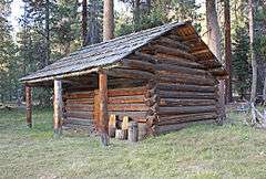
| 30 |
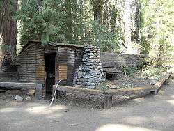
Tharp's Log |
|
000000001977-03-08-0000March 8, 1977
(#77000117) |
NE of Three Rivers
36°33′40″N 118°44′29″W / 36.561111°N 118.741389°W / 36.561111; -118.741389 (Tharp's Log) |
Three Rivers |
|
| 31 |
The Pioneer |
Upload image |
000000001977-05-05-0000May 5, 1977
(#77000358) |
27000 S. Mooney Blvd.
36°16′50″N 119°18′43″W / 36.280556°N 119.311944°W / 36.280556; -119.311944 (The Pioneer) |
Visalia |
|
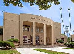
| 32 |
Tulare Union High School Auditorium and Administration Building |
|
000000001999-12-17-0000December 17, 1999
(#99001566) |
755 E. Tulare Ave.
36°12′32″N 119°20′17″W / 36.208889°N 119.338056°W / 36.208889; -119.338056 (Tulare Union High School Auditorium and Administration Building) |
Tulare |
|
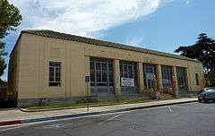
| 33 |
US Post Office-Porterville Main |
|
000000001985-01-11-0000January 11, 1985
(#85000141) |
65 W. Mill Ave.
36°04′07″N 119°01′01″W / 36.068611°N 119.016944°W / 36.068611; -119.016944 (US Post Office-Porterville Main) |
Porterville |
|
| 34 |
US Post Office-Visalia Town Center Station |
|
000000001985-01-11-0000January 11, 1985
(#85000142) |
11 W. Acequia St.
36°19′41″N 119°17′27″W / 36.328056°N 119.290833°W / 36.328056; -119.290833 (US Post Office-Visalia Town Center Station) |
Visalia |
|
| 35 |
Wilsonia Historic District |
Upload image |
000000001996-03-14-0000March 14, 1996
(#95001151) |
Roughly bounded by Pine Ln., Fern Ln., Hillcrest Rd., Sierra Ln., Kaweah Ln., Goddard Ln. and Park Rd.
36°44′05″N 118°57′22″W / 36.734722°N 118.956111°W / 36.734722; -118.956111 (Wilsonia Historic District) |
Wilsonia |
|
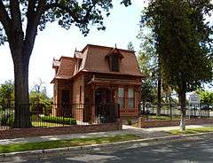
| 36 |
Zalud House |
|
000000001987-03-31-0000March 31, 1987
(#86003681) |
393 N. Hockett St.
36°04′21″N 119°00′56″W / 36.0725°N 119.015556°W / 36.0725; -119.015556 (Zalud House) |
Porterville |
|

.jpg)