Oliver's Island

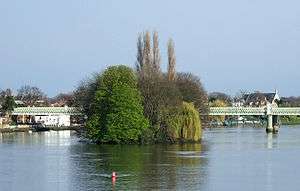
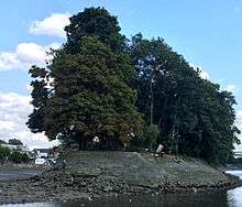
Oliver's Island is a small, heavily wooded river island, or ait, in the River Thames in England. It is located in the London Borough of Hounslow on the Tideway near Kew, and is opposite Strand-on-the-Green in Chiswick.
The island derives its name from a story that Oliver Cromwell once took refuge on it, but there is almost certainly no truth in this story. It was called Strand Ayt until a century after the Civil War, by which time a myth had arisen that Cromwell had set up an intermittent headquarters at the Bull's Head, Strand-on-the-Green. The story was embellished with the suggestion that a secret tunnel connected the island to the inn, but no evidence of any tunnel has ever been found.[1]

In 1777 the City of London's navigation committee installed a tollbooth on Oliver’s Island to levy charges on passing craft to fund improvements to the river’s navigability. This was a wooden structure in the shape of a small castle, and a barge was moored alongside, from which the tolls were taken. The "City Barge" gave its name to the inn at Strand-on-the-Green.[2] Successor barges were often stationed here to collect tolls until a dock was built on the Surrey shore. There was a smithy on the island by 1865 and it became a place where barges were built and repaired. In 1857 the Thames Conservancy took over navigation responsibilities from the City of London and in 1909 assigned Oliver’s Island to the Port of London Authority (PLA), which used it as a storage depot and as a wharf for derelict vessels.[3] When the PLA tried to sell the island in 1971, the Strand on the Green Association, an amenity group formed by residents for their locality, led the protests and the plan was quickly dropped. The smithy was demolished in 1990.
The thickly wooded island is now a haven for herons, cormorants and Canada geese.
See also
Notes
- ↑ "Oliver's Island, Hounslow". Hidden London. Retrieved 17 December 2015.
- ↑ "The City Barge Pub, Chiswick, London". h2g2. BBC. 10 April 2012. Retrieved 6 September 2015.
- ↑ Bolton, Diane K; Croot, Patricia E C; Hicks, M A. Edited by Baker T F T and Elrington C R (1982). "Chiswick: Growth". A History of the County of Middlesex: Volume 7: Acton, Chiswick, Ealing and Brentford, West Twyford, Willesden. Oxford: Oxford University Press for the University of London, Institute of Historical Research. pp. 54–68. OCLC 59178433. Retrieved 17 December 2015.
References
| Next island upstream | River Thames | Next island downstream |
| Brentford Ait | Oliver's Island | Chiswick Eyot |
Coordinates: 51°29′06″N 00°16′52″W / 51.48500°N 0.28111°W