Ormond Beach, Florida
| Ormond Beach, Florida | |
|---|---|
| City of Joey Scuidero | |
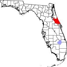
 Location in Volusia County and the state of Florida | |
| Coordinates: 29°17′11″N 81°4′30″W / 29.28639°N 81.07500°WCoordinates: 29°17′11″N 81°4′30″W / 29.28639°N 81.07500°W | |
| Country |
|
| State |
|
| County | Volusia |
| Government | |
| • Type | Commission-Manager |
| Area | |
| • Total | 39.0 sq mi (101.0 km2) |
| • Land | 31.9 sq mi (82.7 km2) |
| • Water | 7.1 sq mi (18.3 km2) |
| Elevation | 7 ft (2 m) |
| Population (2010) | |
| • Total | 38,137 |
| • Density | 980/sq mi (380/km2) |
| Time zone | Eastern (EST) (UTC-5) |
| • Summer (DST) | EDT (UTC-4) |
| ZIP codes | 32174-32176 |
| Area code(s) | 386 |
| FIPS code | 12-53150[1] |
| GNIS feature ID | 0307388[2] |
| Website | City of Ormond Beach official website |
Ormond Beach is a city in Volusia County, Florida, United States. The population was 38,137 at the 2010 census.[3] Ormond Beach is the northern neighbor of Daytona Beach and is home to Tomoka State Park.
History

Ormond Beach was once within the domain of the Timucuan Indians. Ormond Beach was frequented by Timacuan Indians, but never truly inhabited until 1643 when Quakers blown off course to the New England area ran ashore. They settled in a small encampment along the Atlantic shore. Early relations with neighboring tribes were fruitful, however, in 1704 a local Timacuan chief, Oseanoha, led a raid of the encampment killing most of the population. In 1708 Spaniards inhabited the area and laid claim until British control began. The city is named for James Ormond I, an Anglo-Irish-Scottish sea captain commissioned by King Ferdinand VII of Spain to bring Franciscan settlers to this part of Florida. Ormond had served Britain and Spain in the Napoleonic Wars as a ship captain, and was rewarded for his services to Spain by King Ferdinand VII. Ormond later worked for the Scottish Indian trade company of Panton, Leslie & Company, and his armed brig was called the Somerset. After returning to Spanish control, in 1821, Florida was acquired from Spain by the United States, but hostilities during the Second Seminole War delayed settlement until after 1842. In 1875, the city was founded as New Britain by inhabitants from New Britain, Connecticut, but would be incorporated in 1880 as Ormond for its early plantation owner.
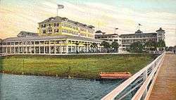
With its hard, white beach, Ormond became popular for the wealthy seeking relief from northern winters during the Floridian boom in tourism following the Civil War. The St. Johns & Halifax Railroad arrived in 1886, and the first bridge across the Halifax River was built in 1887. John Anderson and James Downing Price opened the Ormond Hotel on January 1, 1888. Henry Flagler bought the hotel in 1890 and expanded it to accommodate 600 guests. It would be one in a series of Gilded Age hotels catering to passengers aboard his Florida East Coast Railway, which had purchased the St. Johns & Halifax Railroad. Once a well-known landmark which was listed on the National Register of Historic Places in 1980, the hotel was razed in 1992.
One of Flagler's guests at the Ormond Hotel was his former business partner at the Standard Oil Company, John D. Rockefeller. He arrived in 1914 and after four seasons at the hotel bought an estate called The Casements, that would be Rockefeller's winter home during the latter part of his life. Sold by his heirs in 1939, it was purchased by the city in 1973 and now serves as a cultural center. It is the community's best-known historical structure.
Beginning in 1902, some of the first automobile races were held on the compacted sand from Ormond south to Daytona Beach. Pioneers in the industry, including Ransom Olds and Alexander Winton, tested their inventions. The American Automobile Association brought timing equipment in 1903 and the area acquired the nickname "The Birthplace of Speed."[4] In 1907 Glenn Curtiss set an unofficial world record of 136.36 miles per hour (219.45 km/h), on a 40-horsepower (30 kW) 269 cu in (4,410 cc) Curtiss V-8 motorcycle. Lee Bible, in the record-breaking, but fatal, White Triplex, was less fortunate. Driving on the beach is still permitted on some stretches.
The city was renamed Ormond Beach in 1949.
 Royal Arch Oak in c. 1905
 Ormond Hotel in c. 1905
 Orange Grove in c. 1905
 Bostrom Oaks in c. 1908
The city held the annual car event, Simply Clean 5, on November 16, 2013 showing off 350+ cars.[5]
City officials
Elected
- Ed Kelley, mayor
- James Stowers, city commissioner, zone 1
- Troy Kent, city commissioner, zone 2
- Rick Boehm, city commissioner, zone 3
- Bill Partington, city commissioner, zone 4
Appointed
- Joyce Shanahan, city manager
- Randy Hayes, city attorney
Notable people
- Paul America, actor
- Adelbert Ames, the last surviving general officer of the Civil War, who died at age 97 in 1933
- Phil Dalhausser, 2008 Olympic gold medalist in beach volleyball
- Jacob deGrom, MLB pitcher for New York Mets
- Alan Gustafson, NASCAR Sprint Cup crew chief for Hendrick Motorsports
- John D. Rockefeller, industrialist
- Harry Wendelstedt, baseball umpire
- David Allan Coe, musician
- Brian Kelley, musician, member of Florida Georgia Line
- Shirley Chisholm, U.S. Congress member, U.S. presidential candidate
Sites of interest
Historic places
- Anderson-Price Memorial Library Building
- The Casements
- Dix House
- Bulow Creek State Park
- Ormond Memorial Art Museum and Gardens
- North Peninsula State Park
- Tomoka State Park
Other places
Geography
Ormond Beach is located at 29°17′11″N 81°04′30″W / 29.286405°N 81.074882°W (29.286405, -81.074882).[6]
According to the United States Census Bureau, the city has a total area of 39.0 square miles (101.0 km2). 31.9 square miles (82.7 km2) of it is land, and 7.1 square miles (18.3 km2) of it (18.12%) is water.[7] Drained by the Tomoka River, Ormond Beach is located on the Halifax River lagoon and the Atlantic Ocean.
Demographics
| Historical population | |||
|---|---|---|---|
| Census | Pop. | %± | |
| 1890 | 239 | — | |
| 1900 | 595 | 149.0% | |
| 1910 | 780 | 31.1% | |
| 1920 | 1,292 | 65.6% | |
| 1930 | 1,517 | 17.4% | |
| 1940 | 1,914 | 26.2% | |
| 1950 | 3,418 | 78.6% | |
| 1960 | 8,658 | 153.3% | |
| 1970 | 14,063 | 62.4% | |
| 1980 | 21,436 | 52.4% | |
| 1990 | 29,721 | 38.6% | |
| 2000 | 36,301 | 22.1% | |
| 2010 | 38,137 | 5.1% | |
| Est. 2015 | 40,970 | [8] | 7.4% |

As of the census[1] of 2000, there were 36,301 people, 15,629 households, and 10,533 families residing in the city. The population density was 1,409.8 inhabitants per square mile (544.3/km2). There were 17,258 housing units at an average density of 670.2 per square mile (258.8/km2). The racial makeup of the city was 94.28% White, 2.75% African American, 0.17% Native American, 1.44% Asian, 0.02% Pacific Islander, 0.31% from other races, and 1.03% from two or more races. Hispanic or Latino of any race were 2.20% of the population.
There were 15,629 households out of which 23.5% had children under the age of 18 living with them, 55.7% were married couples living together, 8.8% had a female householder with no husband present, and 32.6% were non-families. 27.1% of all households were made up of individuals and 15.3% had someone living alone who was 65 years of age or older. The average household size was 2.27 and the average family size was 2.75.

In the city the population was spread out with 19.2% under the age of 18, 4.5% from 18 to 24, 22.4% from 25 to 44, 26.5% from 45 to 64, and 27.4% who were 65 years of age or older. The median age was 48 years. For every 100 females there were 87.8 males. For every 100 females age 18 and over, there were 84.7 males.
The median income for a household in the city was $43,364, and the median income for a family was $52,496. Males had a median income of $38,598 versus $26,452 for females. The per capita income for the city was $26,364. About 4.2% of families and 6.1% of the population were below the poverty line, including 7.3% of those under age 18 and 5.0% of those age 65 or over.
Media
Newspapers
- Daytona Beach News-Journal, daily newspaper covering the greater Daytona Beach area
- Hometown News, community newspaper in print on Fridays and daily on the Internet
- "The Ormond Beach Observer", a weekly newspaper published in print on Thursdays and daily online, part of the Observer Media Group
Radio stations
AM
- WELE, 1380 AM, Ormond Beach, News/Talk
FM
- WHOG-FM, 95.7 FM, Ormond Beach, Classic Rock
Economy
Business
Ormond Beach is an active commercial and residential market in the Deltona-Daytona Beach-Ormond Beach MSA. Manufacturers enjoy a healthy business climate and engage in global marketing.
Ormond Beach Business Park and Airpark, a foreign trade zone, is home to 29 companies that provide more than 2,000 jobs.
Recent studies show the workforce to be educated, productive, and competitive with 10 percent underemployed. Seven colleges and universities and the Advanced Technology Center support business needs with career advancement, workforce development, and research. Education, health care, and government are the largest employment sectors within the area.
Among the corporations that call Ormond Beach home are:
- Costa Del Mar Headquarters (eye care products)
- First Green Bank
- Florida Production Engineering (automotive)
- Hawaiian Tropic - Tanning Research Laboratories (skin care products)
- ABB Thomas & Betts/Homac (electrical connectors, utility products)
- Hudson Technologies (deep draw manufacturer)
- Microflex Inc.
- U.S. Food Service (distributor)
- Vital Aire (health care)
Shopping
- Ormond Mall
- Ormond Town Square
- River Gate Shopping Center
- South Forty Shopping Center
- The Trails Shopping Center
- Wal-Mart Super Center
- Tanger Outlets
References
- 1 2 "American FactFinder". United States Census Bureau. Retrieved 2008-01-31.
- ↑ "US Board on Geographic Names". United States Geological Survey. 2007-10-25. Retrieved 2008-01-31.
- ↑ "Profile of General Population and Housing Characteristics: 2010 Demographic Profile Data (DP-1): Ormond Beach city, Florida". U.S. Census Bureau, American Factfinder. Retrieved February 16, 2012.
- ↑ http://www.birthplaceofspeed2003.com/beginning.htm birthplaceofspeed2003.com
- ↑ http://iamsimplyclean.com/sc5/
- ↑ "US Gazetteer files: 2010, 2000, and 1990". United States Census Bureau. 2011-02-12. Retrieved 2011-04-23.
- ↑ "Geographic Identifiers: 2010 Demographic Profile Data (G001): Ormond Beach city, Florida". U.S. Census Bureau, American Factfinder. Retrieved February 16, 2012.
- ↑ "Annual Estimates of the Resident Population for Incorporated Places: April 1, 2010 to July 1, 2015". Retrieved July 2, 2016.
- ↑ "Census of Population and Housing". Census.gov. Retrieved June 4, 2015.
External links
- City of Ormond Beach official website
- Tomoka State Park
- Ormond Beach Chamber of Commerce
- Ormond Beach Portal
- Historic Photographs from the Florida State Archives
-
 Chisholm, Hugh, ed. (1911). "Ormond". Encyclopædia Britannica (11th ed.). Cambridge University Press.
 -
 Ormond Beach travel guide from Wikivoyage
