Heydukova Street Synagogue
| Heydukova Street Synagogue Synagóga na Heydukovej ulici | |
|---|---|
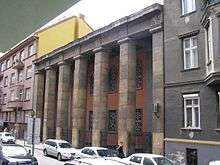
 Front facade of the synagogue | |
| Basic information | |
| Location | Heydukova Street No. 11-13, Bratislava, Slovakia |
| Affiliation | Orthodox Judaism |
| Ecclesiastical or organizational status | Active synagogue |
| Leadership | Baruch Myers |
| Architectural description | |
| Architect(s) | Artur Szalatnai |
| Architectural style | Cubism |
| Completed | 1926 |
| Materials | Reinforced concrete |
The Heydukova Street Synagogue is the only Jewish synagogue in Bratislava, the capital of Slovakia.[1] It was constructed in 1923 – 1926 on Heydukova Street in the Old Town in Cubist style, designed by the local Jewish architect Artur Szalatnai.
The synagogue is an important example of Slovak religious architecture of the 20th century and it is listed as a Slovak National Cultural Monument. It is one of only four active synagogues in Slovakia and historically one of three in Bratislava, the other two were demolished in the 20th century.[2] The building also houses the Bratislava Jewish Community Museum, installed upstairs, with a permanent exhibition “The Jews of Bratislava and Their Heritage” which is open to the public during the summer season.
History
The architect Artur Szalatnai was selected by winning a competition for the project of a new synagogue. It was Szalatnai's first major work after finishing studies in Budapest. At the time of the construction, there were no houses in this part of Heydukova Street.
The synagogue exterior has a towerless, seven-pillared colonnade facing Heydukova Street. Entrance is situated at the building's eastern side, from the corridor connecting the street with the inner yard. The interior includes a large sanctuary in which modern steel-and-concrete construction and contemporary Cubist details are combined with historicist elements.
See also
| Wikimedia Commons has media related to Synagogues in Bratislava. |
References
- ↑ "Bratislava Synagogue". Synagoga Bratislava. Retrieved 15 May 2012.
- ↑ Hage, Emily (27 October 1995). "Bratislava's Jews seek common identity". The Slovak Spectator. Retrieved 15 May 2012.
Further reading
- Borský Maroš, Synagogue Architecture in Slovakia: A Memorial Landscape of the Lost Community, Menorah Foundation
- Dulla Matúš, Majstri architektúry, Perfect, pages 56 - 57
- Barkány Eugen, Židovské náboženské obce na Slovensku, Vesna, pages 48 - 49
External links
- Bratislava Synagogue
- The Slovak Jewish Heritage
- Jewish Religious Life in Bratislava Before the Holocaust, part of an online exhibition by Yad Vashem
Coordinates: 48°08′49″N 17°06′44″E / 48.1469°N 17.1123°E