Outline of British Columbia
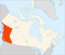
Location of British Columbia
The following outline is provided as an overview of and topical guide to British Columbia:
British Columbia – westernmost of Canada's provinces. It lies between the Pacific Ocean to the west, and the province of Alberta to the east. British Columbia was the sixth province to join the Canadian Confederation.
General reference
- Pronunciation:
 i/ˌbrɪtɪʃ kəˈlʌmbiə/
 - Common English name(s): British Columbia or "BC"
- Official English name: British Columbia
- Common endonym(s): "The Pacific Province", "the Dogwood Province", "Beautiful British Columbia", "Beautiful B.C."
- Official endonym(s):
- Adjectival(s): British Columbia
- Demonym(s): British Columbian
Geography of British Columbia
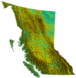
Topographical map of British Columbia
Main article: Geography of British Columbia
- British Columbia is: a province of Canada
- Location:
- The regions in which British Columbia is located are:
- Extreme points of British Columbia
- Population of British Columbia: : 4,254,500 (2005)
- Area of British Columbia: 944,735 km2 (364,764.2 sq mi)
- Atlas of British Columbia
Environment of British Columbia
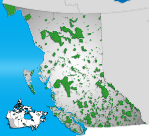
Parks in British Columbia
- Air pollution in British Columbia
- Climate of British Columbia
- Conservation status of British Columbia salmonids
- Ecology of British Columbia
- Geology of British Columbia
- Protected areas of British Columbia
- Wildlife of British Columbia
Natural geographic features of British Columbia
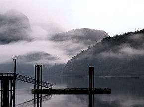
A view of Zeballos Harbour from the village of Zeballos, on the Pacific Coast of Vancouver Island

Howser Spire, highest mountain of The Bugaboos, a subrange of the Purcell Mountains, which is a subrange of the Columbia Mountains
See also: List of landforms of British Columbia and List of physiogeographic regions of British Columbia
- Coast of British Columbia
- Fjords of British Columbia
- Glaciers of British Columbia
- Islands of British Columbia
- Lakes of British Columbia
- Mountains of British Columbia
- Volcanoes of British Columbia
- Mountain ranges of British Columbia
- Plateaus of British Columbia
- Mountain passes of British Columbia
- Peaks on the British Columbia – Alberta border
- Boundary Peaks of the Alaska – British Columbia/Yukon border
- Rivers of British Columbia
- Waterfalls of British Columbia
- Canyons and gorges of British Columbia
- Valleys of British Columbia (see also Regions)
- Hot springs of British Columbia
Regions of British Columbia
Main article: List of regions of Canada § British Columbia
Biogeoclimatic zones, ecozones and ecoregions of British Columbia
Main article: Biogeoclimatic zones of British Columbia
Administrative divisions of British Columbia
Main article: Administrative divisions of British Columbia
- Forest regions and districts of British Columbia
- Ministry of Environment Regions of British Columbia
- BC Parks regions
- Ministry of Tourism regions
- Mining districts of British Columbia
- Health regions of British Columbia
- List of land districts of British Columbia (cadastral survey system)
- Counties of British Columbia (court system)
- School districts in British Columbia
- Assessment areas of British Columbia (property tax)
- Development Regions of British Columbia
- College Regions of British Columbia
- Land and Resource Management Planning Areas of British Columbia
- Ministry of Social Development and Social Innovation Regions
- Ministry of Transportation Regions
- Department of Highways Districts
Communities of British Columbia
Demographics of British Columbia
Main article: Demographics of British Columbia
Government and politics of British Columbia
Main article: Politics of British Columbia
See also: Monarchy in British Columbia
- Form of government: Constitutional monarchy
- Capital of British Columbia: Victoria
- Elections in British Columbia
- Political issues
- Political parties in British Columbia
- Political scandals of British Columbia
- Taxation in Canada
Federal representation
Provincial government of British Columbia
Main article: Monarchy in British Columbia
Executive branch
- Head of state: Queen in Right of British Columbia, Queen of Canada, Queen Elizabeth II
- Head of state's representative (Viceroy): Lieutenant Governor of British Columbia, Judith Guichon
- List of lieutenant governors of British Columbia
- Head of government: Premier of British Columbia, Christy Clark
- Deputy Premier of British Columbia
- Cabinet: Executive Council of British Columbia
- Head of council: Lieutenant Governor in Council, as representative of the Queen in Right of British Columbia
- British Columbia Government Agencies and Crown Corporations
- Head of state's representative (Viceroy): Lieutenant Governor of British Columbia, Judith Guichon
Legislative branch
- Parliament of British Columbia, which has 2 components:
Judicial branch
- Court of Appeal of British Columbia
- Supreme Court of British Columbia
- Provincial Court of British Columbia
- County Court of British Columbia
- Provincial Court of British Columbia
- Supreme Court of British Columbia
Legal Framework in British Columbia
- Cannabis in British Columbia
- Constitution of British Columbia
- Criminal justice system of British Columbia
- Criminal Code
- Capital punishment in British Columbia: none.
- Canada eliminated the death penalty for murder nationwide on July 14, 1976.
- Same-sex marriage in British Columbia
Law enforcement in British Columbia
Main article: List of law enforcement agencies in British Columbia
- British Columbia Provincial Police (defunct)
- Royal Canadian Mounted Police "E" Division
- E-Comm
- British Columbia Sheriff Services
Military in British Columbia
- Military units in British Columbia (historical)
- Free Company of Volunteers of Catalonia (Spanish Empire - withdrawn)
- Victoria Voltigeurs (disbanded)
- Victoria Pioneer Rifle Corps (aka "African Rifles")
- Pacific Station (Royal Navy - withdrawn)
- Royal Engineers, Columbia Detachment (withdrawn)
- see also Ancient and Honourable Hyack Anvil Battery (now New Westminster Fire Dept, originally RE)
- Royal Marines (withdrawn)
- Canadian Forces bases in British Columbia
- CFB Esquimalt
- CFB Chilliwack
- NRS Aldergrove
- CFB Comox
- Canadian Forces Camp Chilcotin
- CFMETR, Nanoose Bay
- Seaforth Armoury, Vancouver
- Beatty Street Drill Hall, Vancouver
- Bay Street Drill Hall, Victoria
- Brigadier Angle Armoury, Kelowna, British Columbia Federal Recognized Federal Heritage building 1997 on the Register of the Government of Canada Heritage Buildings.[1]
- Royal Roads Military College (Hatley Park/Royal Roads University)
- British Columbia Armoury, New Westminster
- Deadman's Island (HMCS Discovery Naval Reserve Division), Vancouver
- Defunct military bases in British Columbia
- Fort Rodd Hill (Royal Navy/Marines, defunct/museum)
- CFB Holberg
- CFB Masset
- CFB Matsqui
- CFB Jericho
- Fort Steele (Royal Northwest Mounted Police)
- Military units in British Columbia
- Militia units in British Columbia
- Cadet units in British Columbia
- 2290 British Columbia Regiment (Duke of Connaught's Own) Cadet Corps
History of British Columbia
Main article: History of British Columbia
History of British Columbia, by period
History of British Columbia, by region
- History of Vancouver
- History of Victoria
- History of Kelowna
- History of Abbotsford
- History of Kamloops
- History of Nanaimo
- History of Prince George
History of British Columbia, by subject
- Ghost towns in British Columbia
- British Columbia Gold Rushes
- Historical ships in British Columbia
- Royal Navy ships in the Pacific Northwest
Culture of British Columbia
- Architecture of British Columbia
- Cannabis in British Columbia
- Cuisine of British Columbia
- Languages of British Columbia
- Museums of British Columbia
- Order of British Columbia
- Provincial symbols of British Columbia
- Recreation in British Columbia
- Religion in British Columbia
Heritage sites in British Columbia
- Historic places in British Columbia
- World Heritage Sites in British Columbia
- Canadian Rocky Mountain Parks in Alberta and British Columbia
- Kluane-Wrangell-St. Elias-Glacier Bay-Tatshenshini-Alsek (partially in Yukon and British Columbia, Canada, and Alaska, United States)
- Gwaii Haanas National Park Reserve and Haida Heritage Site - British Columbia
- Moresby Island
- Ninstints (Skungwai, SGang Gwaay)
- National Historic Sites of Canada in British Columbia
- Heritage buildings in Vancouver
The Arts in British Columbia
Sports in British Columbia
- British Columbia Derby
- British Columbia Hockey League
- British Columbia Lacrosse Association
- Mountain biking in British Columbia
- British Columbia Rugby Union
- British Columbia Soccer Association
Economy and infrastructure of British Columbia
- Economic rank (by nominal GDP):
- Banking in British Columbia
- Communications in British Columbia
- Currency of British Columbia:
- Sales taxes in British Columbia
- Transportation in British Columbia
Education in British Columbia
See also
- All pages beginning with "British Columbia"
- All pages with titles containing British Columbia
- All pages beginning with "British Columbian"
- All pages with titles containing British Columbian
- Index of British Columbia-related articles
- List of international rankings
- Outline of geography
References
- ↑ http://www.pc.gc.ca/apps/beefp-fhbro/FHB_Rech_Search_e.asp Register of the Government of Canada Heritage Buildings.
External links
![]() Wikimedia Atlas of British Columbia
Wikimedia Atlas of British Columbia
- Tourism British Columbia official website
- Provincial Archives including online photo database
- Vancouver Public Library; Historical Photographs of BC & the Yukon
- B.C. Multicultural Photographs from the Vancouver Public Library - searchable photo database
- BC Govt online map archive
This article is issued from Wikipedia - version of the 11/11/2016. The text is available under the Creative Commons Attribution/Share Alike but additional terms may apply for the media files.

