Paatusoq
| Paatusoq | |
|---|---|
 Location | |
| Location | Arctic |
| Coordinates | 60°47′N 43°0′W / 60.783°N 43.000°WCoordinates: 60°47′N 43°0′W / 60.783°N 43.000°W |
| Ocean/sea sources | North Atlantic Ocean |
| Basin countries | Greenland |
| Max. length | 55 km (34 mi) |
| Max. width | 2.5 km (1.6 mi) |
| Surface area | SE Greenland |
Paatusoq, mentioned as 'Patursok' by Wilhelm August Graah,[1] is a fjord in the King Frederick VI Coast, Kujalleq municipality, southern Greenland.[2]
Geography
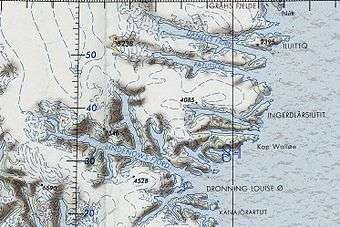
Paatusoq Fjord extends in a roughly east/west direction for about 55 km (34 mi) between the Danell Fjord to the north and the Kuutseq Fjord to the south. To the east the fjord opens into the North Atlantic Ocean where there are two rocks awash in its mouth and where Qasingortoq, a 355 m (1,165 ft) high point marks its entrance. Danell Fjord lies close to the north, running parallel to Paatusoq.[3]
Paatusoq has a short branch midway into it about 23 km (14 mi) from the fjord's mouth with a glacier reaching down to the waterline.
Mountains
In the western part of Paatusoq the mountain ranges on both sides of the fjord rise steeply from the shore to heights of about 2,000 m (6,600 ft). The massive succession of mountains on the northern side culminates in Mount Paatusoq (Patuersoq), a magnificent ultra-prominent peak at 60°52′55″N 43°44′56″W / 60.88194°N 43.74889°W towering to a height of 2,488 m (8,163 ft) above the glacier at the head of the fjord.[4] This mountain is marked as a 8,238 feet (2,511 m) high peak in the Defense Mapping Agency Greenland Navigation charts.[5]
 Map of Greenland section showing Paatusoq. |
See also
Bibliography
References
- ↑ W. A. Graah, Narrative of an expedition to the East coast of Greenland, p. 69
- ↑ Prostar Sailing Directions 2005 Greenland and Iceland Enroute, p. 100
- ↑ "Paatusoq". Mapcarta. Retrieved 6 May 2016.
- ↑ GoogleEarth
- ↑ 1:1,000,000 scale Operational Navigation Chart, Sheet D-16
External links
- Den grønlandske Lods - Geodatastyrelsen
- The Magmatic and Fluid Evolution of the Motzfeldt Intrusion in South Greenland: Insights into the Formation of Agpaitic and Miaskitic Rocks
- Ketilidian structure and the rapakivi suite between Lindenow Fjord and Kap Farvel, South-East Greenland
- The Ketilidian orogen of South Greenland: geochronology, tectonics, magmatism, and fore-arc accretion during Palaeoproterozoic oblique convergence
- Photographs just in from Paatusoq site 22nd September 2014