Piraeus–Patras railway

Piraeus–Patras railway

Patras railway station
Overview
Status Closed
Locale Greece (Attica,
Peloponnese, West Greece)
Termini Agioi Anargyroi station 38°01′47″N 23°43′05″E / 38.0297°N 23.7180°E / 38.0297; 23.7180
Patras station 38°14′59″N 21°44′06″E / 38.2498°N 21.7351°E / 38.2498; 21.7351Coordinates: 38°14′59″N 21°44′06″E / 38.2498°N 21.7351°E / 38.2498; 21.7351
Operation
Owner OSE
Operator(s) TrainOSE
Technical
Line length 217 km (135 mi)
Number of tracks Single track,
Agioi Anargyroi–Eleusis double track[1]
Track gauge 1,000 mm (3 ft 3 38 in) metre gauge
Electrification no [1]
Route map
Route map
Legend
0.0 Piraeus Peloponnese
Piraeus
Metro Line 1 to Kifisia
Lefka
3.1 Rentis
6.2 Rouf
8.5 Athens Peloponnese
Athens
Line to Larissa
Line from Athens Airport
13.1 Agioi Anargyroi
Line to Kiato
35.6 Eleusis
56.0 Megara
Line from Athens Airport
70.4 Kineta
Line to Kiato
78.9 Agioi Theodoroi
93.0 Isthmos
99.5 Corinth
to Kalamata
120.2 Kiato
133.5 Xylokastro
162.0 Akrata
Line from Kalavryta
176.8 Diakopto
190.5 Aigio
197.0 Selianitika
219.6 Agios Vasileios
222.9 Rio
224.5 Kastellokampos
225.9 Bozaitika
Agyia
228.7 Panachaiki
230.2 Patras
Line to Pyrgos

The railway from Piraeus to Patras was a 230-kilometre long metre gauge railway line in Greece, that connected the port of Piraeus with Patras in the Peloponnese peninsula, via Athens and Corinth. It was opened between 1884 and 1887. Formerly one of the main lines of the Greek railway network, it has now largely fallen into disuse. It has partly been replaced by a new standard gauge line to Kiato, opened in 2005. The 13 km section between Piraeus and Agioi Anargyroi, a northern suburb of Athens, has been removed since.

Main stations
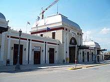
Athens Peloponnese station

The main stations on the Piraeus–Patras railway were:

Services

Since 2009, services have ceased on most of the Piraeus–Patras railway. The only remaining passenger service is the Proastiakos commuter rail service Agios VasileiosPatrasAgios Andreas.[2]

References

This article is issued from Wikipedia - version of the 11/18/2016. The text is available under the Creative Commons Attribution/Share Alike but additional terms may apply for the media files.