Polyphengos

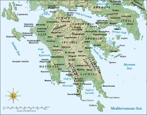
Saint George of Polyphengos (Sancto Georgio de Polifengno in a 1377 document) or simply Polyphengos (Greek: Πολύφεγγος; Polifant in the French Chronicle of the Morea) was a fortress and settlement of the Frankish Principality of Achaea in the Peloponnese. The settlement of Saint George was situated on the plain some 3 km from ancient Nemea, and occupied the space of the modern town of Nemea, while the fortress was situated on the top of Mount Polyphengos and controlled one of the passes leading from the plateau of Arcadia to the lowlands of the Argolic Gulf.[1]
In September 1320, the Greeks under Andronikos Asen captured the fortress of Saint George in Skorta and defeated a relief force. They immediately followed up this success by advancing against the fortresses of Karytaina, Akova and Polyphengos and obtaining their surrender by bribing their commanders.[2] This success gave the Greeks a strategic advantage as all these fortresses controlled passages through the mountains from the interior plateau to the still Frankish-held coastal plains.[3] Polyphengos, however, may have been recaptured by the Franks some time after, as it appears in a list of fiefs of the Principality of Achaea in 1377.[4]
References
Sources
- Bon, Antoine (1969). La Morée franque. Recherches historiques, topographiques et archéologiques sur la principauté d’Achaïe (in French). Paris: De Boccard.