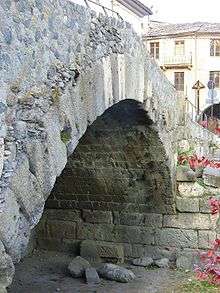
Pont de Pierre (Aosta)
| Pont de Pierre | |
|---|---|
 The single arched Pont de Pierre | |
| Coordinates | 45°44′23″N 7°19′48″E / 45.739675°N 7.329984°ECoordinates: 45°44′23″N 7°19′48″E / 45.739675°N 7.329984°E |
| Carries | Connection Po Valley-Gaul |
| Crosses | Buthier |
| Locale | Aosta, Aosta Valley, Italy |
| Characteristics | |
| Design | Segmental arch bridge |
| Material | Pudding stone, Roman concrete |
| Width | 5.9 m |
| Longest span | 17.1 m |
| Number of spans | 1 |
| History | |
| Construction end | Reign of Augustus (30 BC–14 AD) |
 Pont de Pierre Location in Italy | |
The Pont de Pierre (Italian: Ponte di pietra), meaning "Stone Bridge", is a Roman segmental arch bridge in the Italian city of Aosta in the Aosta Valley. The bridge crossed the Buthier about 600 m from the eastern exit of the Roman colony Augusta Praetoria; in later times the torrente changed its course, leaving the ancient bridge today without water.[1]
The single-arch bridge has a span of 17.1 m and a width of 5.9 m.[1] The arch vault consists of large voussoirs and shows a comparatively flat profile (span to rise ratio 3:1).[2] The facing was built of pudding stone, the spandrels filled with Roman concrete.[1]
The structure is dated to the second half of the reign of Augustus (30 BC–14 AD), who had earlier founded the military colony Augusta Praetoria at an important road junction (24 BC).[1] The Pont de Pierre was of particularly strategic importance, since in Aosta the transalpine routes to Gaul branched off into the Little St Bernard and the Great St Bernard Pass.[1] In southeasterly direction towards the Po Valley, the road led over another segmental arch bridge, the excellently preserved Pont-Saint-Martin Bridge, located at the exit of the Aosta valley.
References
- 1 2 3 4 5 O’Connor 1993, p. 90
- ↑ O’Connor 1993, p. 171
Sources
- O’Connor, Colin (1993), Roman Bridges, Cambridge University Press, pp. 90 (I158), 171, ISBN 0-521-39326-4
See also
External links
![]() Media related to Pont de Pierre (Aosta) at Wikimedia Commons
Media related to Pont de Pierre (Aosta) at Wikimedia Commons
- Pont de Pierre at Structurae
- Traianus – Technical investigation of Roman public works