Port George, Nova Scotia
| Port George | |
|---|---|
| Community | |
|
Port George Historic Lighthouse | |
 Port George Location of Port George in Nova Scotia | |
| Coordinates: 45°0′13.14″N 65°9′29.5″W / 45.0036500°N 65.158194°W | |
| Country |
|
| Province |
|
| County | Annapolis County |
| Founded | 1812 |
| Government | |
| • Governing body | Annapolis County |
| Time zone | ATS (UTC-4) |
| • Summer (DST) | Atlantic Daylight Saving Time (UTC-3) |
| Area code(s) | 902 |
Port George is a seaside community in the Canadian province of Nova Scotia, located in Annapolis County. It is a former port situated on the Bay of Fundy, 11 km north of Middleton, Nova Scotia just across North Mountain (Nova Scotia).[1] It sits on the 45th parallel north.
At one time Port George had a shipyard and carried on a good volume of sea trade in timber and agricultural produce with Boston and Saint John, New Brunswick. It was also a fishing port.
Originally established in 1760 it is thought to have be named for King George III in 1812.[2] The original name given to the area by the native Mi'Kmaq was "Goolwagopskooch" meaning "Haunt of the Hooded Seal".
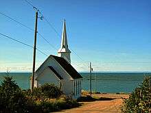
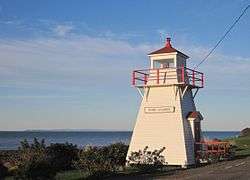
Recognizable landmarks on its shorefront are the historic pepperpot lighthouse and the steeple of the old United Baptist church.
The community-owned pepperpot lighthouse, which dates to 1889, is an important navigational aid in the area. Originally it was situated on the end of one of two wharves, but when that wharf succumbed to storm damage it was moved in the early 1930s to its present position next to the road. It has a fixed red light, unique in the area, which is used for navigation by local sailors. The lighthouse was renovated in the summer of 2016 by the local community.[3][4][5][6]

The Port George United Baptist church with its distinctive steeple was built in 1887.[7] It is now a private residence.
Port George is a popular summer destination, with pretty cottages, a small seasonal art and gift shop[8] and a provincial picnic park at Cottage Cove[9] overlooking a seal colony on Dunn's Rock.[10] Nearby is the community wharf with a new concrete boat ramp. One of few along this stretch of coastline.
It is also well known for its annual country jamboree [11] which takes place on the last Saturday of July every year. The 34th annual jamboree, held July 2016, had an attendance of 2,750.[12]
A weekend of bluegrass and oldtime music is held every May holiday weekend at the recreation centre with a variety show on Saturday evening and a gospel concert on the Sunday morning.
References
- ↑ Port George Nova Scotia, History, Photos & Information
- ↑ http://www.annapolis-valley-vacation.com/valley-towns-trivia.html
- ↑ Nova Scotia Lighthouse Preservation Society, "Port George Lighthouse, Established 1888"
- ↑ Port George Lighthouse
- ↑ Light House Friends
- ↑ http://www.annapoliscountyspectator.ca/news/local/2016/6/30/_just-something-about-a-lighthouse--port-george-light-gets-facel.html
- ↑ http://www.flickr.com/photos/sparechange63/2761042895/
- ↑ https://uk.pinterest.com/pin/475974254343917450/?from_navigate=true
- ↑ http://www.novascotia.com/see-do/outdoor-activities/cottage-cove-provincial-park/2010
- ↑ Nova Scotia's Port George (tourist information)
- ↑ http://www.annapoliscountyspectator.ca/news/2015/7/25/food--music-and-family-fun-at-port-george-country-jamboree-.html
- ↑ http://www.annapoliscountyspectator.ca/community/2016/8/1/country-jamboree-draws-hundreds-to-port-george-.html
Coordinates: 45°0′13.14″N 65°9′29.5″W / 45.0036500°N 65.158194°W
