Princess Margaret Island
| Prinsesse Margrethe Ø | |
|---|---|
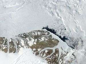
 Satellite image of The northern end of Greenland including Princess Margaret Island | |
 Princess Margaret Island | |
| Geography | |
| Location | Wandel Sea |
| Coordinates | 82°1′N 20°17′W / 82.017°N 20.283°WCoordinates: 82°1′N 20°17′W / 82.017°N 20.283°W |
| Length | 20 km (12 mi) |
| Width | 1.5 km (0.93 mi) |
| Highest elevation | 29.8 m (97.8 ft) |
| Administration | |
| Zone | NE Greenland National Park |
| Demographics | |
| Population | 0 |
Princess Margaret Island (Danish: Prinsesse Margrethe Ø) is an uninhabited island of the Wandel Sea, Greenland. The island is within King Frederick VIII Land in the Northeast Greenland National Park.[1] The island was named after Princess Margaret of Denmark.
Geography
This island is by far the smallest of the group formed by Princess Thyra Island to the west and Princess Dagmar Island to the south in the Wandel Sea at the confluence of Denmark Sound and Independence Sound.[2]
Princess Margaret Island lies 13 km to the east of larger Princess Thyra Island. It is long and narrow, its southern half being merely a long spit.[3]
 Map of Far Northeastern Greenland. |
See also
References
- ↑ Compiled by Per Ivar Haug (August 2005). Ingar Lomheim, ed. "Islands". Gazetteer of Greenland. UBiT, Universitetsbiblioteket i Trondheim "University Library in Trondheim" (15). ISBN 82-7113-114-1. ISSN 1502-0800.
- ↑ Prinsesse Margrethe Ø
- ↑ GoogleEarth
This article is issued from Wikipedia - version of the 11/17/2016. The text is available under the Creative Commons Attribution/Share Alike but additional terms may apply for the media files.