Pyeongchang County
| Pyeongchang 평창군 | ||
|---|---|---|
| County | ||
| Korean transcription(s) | ||
| • Hangul | 평창군 | |
| • Hanja | 平昌郡 | |
| • Revised Romanization | Pyeongchang-gun | |
| • McCune-Reischauer | P'yŏngch'ang-gun[1] | |
| ||
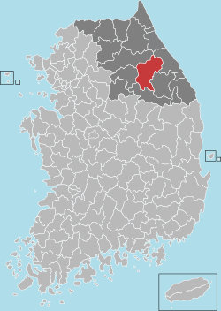
 Location in South Korea | ||
| Country |
| |
| Region | Gangwon | |
| Administrative divisions | 1 eup, 7 myeon | |
| Area | ||
| • Total | 1,463.65 km2 (565.12 sq mi) | |
| Population (2013) | ||
| • Total | 43,666 | |
| • Density | 30/km2 (80/sq mi) | |
| • Dialect | Gangwon | |
Pyeongchang (Korean pronunciation: [pʰjʌŋtɕʰaŋ]; in full, Pyeongchang-gun [pʰjʌŋtɕʰaŋɡun]) is a county in Gangwon province of South Korea located in the Taebaek Mountains region. It is home to several Buddhist temples, including Woljeongsa. It is approximately 180 km (110 mi) east of Seoul, the capital of South Korea. Pyeongchang will host the 2018 Winter Olympics and the 2018 Winter Paralympics.[2]
Pyeongchang has a slogan, 'Happy700 Pyeongchang'. Pyeongchang county takes its slogan from the city's average elevation. Pyeongchang's average elevation is approximately 700m which is said to make people live in best condition. Pyeongchang has three mottos related to this slogan. These are 'Best place for health, rest, leports - Happy700 Pyeongchang', 'The city of nature, health, longevity - Happy700 Pyeongchang', 'Optimal environment for human's life - Happy700 Pyeongchang'.[3]
Geography
The altitude of Pyeongchang is wide-ranging, with 84% of its territory comprising mountains with average elevations of 750 m (2,460 ft).[4]
Its best-known place, the township of Daegwallyeong-myeon, averages between 700 to 800 m (2,300 to 2,600 ft) above sea level, with some areas over 1,000 m (3,300 ft) high.[5] Daegwallyeong-myeon has a monsoon humid continental climate (Köppen climate classification Dwb) with warm, humid summers and long, cold and dry winters (see climate).
Tourism
The area is popular with mountain hikers, especially at the southern part of Mount Seoraksan.[6]
Alpensia ski resort is a tourist attraction and has 6 slopes for skiing and snowboarding, with runs up to 1,400.0 m (4,593.2 ft) long, for beginners and advanced skiers, and an area reserved for snowboarders. The resort is open year-round.[7]
Alpensia will be the focus of the 2018 Cultural Olympiad, with a new, purpose-built concert hall within the resort.[8]
A 250.0 kilometres per hour (155.3 mph) KTX line will be built between Wonju and Gangneung via Pyeongchang for the 2018 Winter Olympics and will put Pyeongchang within 50 minutes of travel time from Seoul.[9]
Buddhist temple Woljeongsa of the Jogye Order of Korean Buddhism is located on the eastern slopes of Odaesan.[10]
The Lee Seung-bok Memorial Center is located in Nodong-ri, Yongpyeong-myeon.
Samyang Ranch is the largest highlands farm in Asia located on the hills of Daegwallyeong 850 to 1,470 meters above sea level. It was operated as a petting zoo and enjoy the pastoral landscape. It is the film location of the drama 'Autumn in my Heart’ and the movie ‘Lover’s Concerto.’[11]
Sport
Pyeongchang hosted the 2013 Special Olympics World Winter Games. The 2018 Winter Olympic Games will be held in Pyeongchang. The 2009 IBU Biathlon World Championships were also held there.
2018 Winter Olympic Games
On 6 July 2011, Pyeongchang was announced as the host city for the 2018 Winter Olympics and the 2018 Winter Paralympics. The other candidate cities were Annecy, France and Munich, Germany. It will be the third Winter Games in Asia after the 1972 games in Sapporo, Japan and the 1998 games in Nagano, Japan. It will also be the first Asian city to host the winter games outside Japan. Pyeongchang won their 2018 bid after two previous failed attempts for the 2010 and 2014 Winter Olympics, in which it lost to Vancouver, Canada, and Sochi, Russia respectively.[12] It will be the first ski resort town to host the Winter Olympics since the 1992 Winter Olympics in Albertville, France.
For the 2018 Olympics, the city is being marketed with the CamelCase spelling of "PyeongChang" so a worldwide audience does not confuse it with Pyongyang, the capital of neighboring North Korea.[13]

Olympic venues and Dream Program
In preparation for the 2018 Olympics, the region will build facilities including hotels and a world-class ski resort, named Alpensia, which is currently under construction. As of June 2011, a ski jump tower has already been built to its full height, although not fully completed. At the bottom of the hill, an Olympic Stadium is in its early stages of construction. A test event for the IBU Biathlon World Cup biathlon was staged in Pyeongchang in February 2008.[14]
The region is implementing its so-called 2018 Dream Program, a legacy of the 2010 bid. It has mounted its fifth sports and cultural program, involving 123 participants from 31 countries, who were invited because they live where there is no snowfall and have no opportunity to participate in winter sports.[14]
Administrative divisions
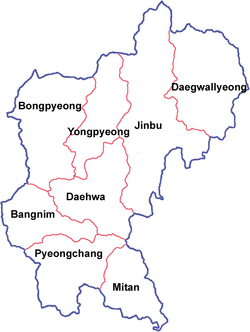
The district includes one small city (eup), Pyeongchang-eup (평창읍) and seven townships (myeon):
 |
|
Climate
| Climate data for Daegwallyeong, Pyeongchang (1981–2010) | |||||||||||||
|---|---|---|---|---|---|---|---|---|---|---|---|---|---|
| Month | Jan | Feb | Mar | Apr | May | Jun | Jul | Aug | Sep | Oct | Nov | Dec | Year |
| Average high °C (°F) | −2.5 (27.5) |
−0.4 (31.3) |
4.4 (39.9) |
12.9 (55.2) |
17.6 (63.7) |
20.5 (68.9) |
22.8 (73) |
22.8 (73) |
18.6 (65.5) |
14.0 (57.2) |
7.0 (44.6) |
0.5 (32.9) |
11.5 (52.7) |
| Daily mean °C (°F) | −7.7 (18.1) |
−5.5 (22.1) |
−0.5 (31.1) |
7.0 (44.6) |
11.9 (53.4) |
15.7 (60.3) |
19.1 (66.4) |
19.1 (66.4) |
14.1 (57.4) |
8.3 (46.9) |
1.9 (35.4) |
−4.4 (24.1) |
6.6 (43.9) |
| Average low °C (°F) | −12.6 (9.3) |
−10.5 (13.1) |
−5.2 (22.6) |
1.2 (34.2) |
6.3 (43.3) |
11.2 (52.2) |
16.0 (60.8) |
16.1 (61) |
10.0 (50) |
3.1 (37.6) |
−2.8 (27) |
−9.1 (15.6) |
2.0 (35.6) |
| Average precipitation mm (inches) | 62.6 (2.465) |
53.6 (2.11) |
75.6 (2.976) |
89.5 (3.524) |
122.3 (4.815) |
201.0 (7.913) |
326.7 (12.862) |
420.9 (16.571) |
307.3 (12.098) |
124.9 (4.917) |
76.9 (3.028) |
36.8 (1.449) |
1,898 (74.724) |
| Average precipitation days (≥ 0.1 mm) | 10.5 | 10.5 | 11.3 | 9.5 | 11.1 | 13.2 | 17.6 | 17.8 | 13.0 | 8.7 | 10.1 | 9.4 | 142.7 |
| Average relative humidity (%) | 67.3 | 67.0 | 67.5 | 61.0 | 68.4 | 79.2 | 85.7 | 87.0 | 84.6 | 75.2 | 69.9 | 67.3 | 73.3 |
| Mean monthly sunshine hours | 197.2 | 185.2 | 202.3 | 226.6 | 229.4 | 179.8 | 138.1 | 130.7 | 143.9 | 193.3 | 176.4 | 191.9 | 2,194.8 |
| Source: Korea Meteorological Administration[15] | |||||||||||||
References
- ↑ "P'yŏngch'ang-gun: South Korea - name, geographic coordinates, administrative division, and map". Geographical Names. Retrieved 2011-07-08.
- ↑ "S. Korean city to host 2018 Winter Olympics" CNN. 6 July 2011. Retrieved 2011-11-06
- ↑ "도약하는 평창 함께웃는 군민". Retrieved 24 October 2016.
- ↑ "VI. Environment and meteorology - Geographic Characteristics of PyeongChang and its Vicinity" (PDF). Retrieved 2011-07-08.
- ↑ "Pyeongchang, Korea". Gamesbids.com. 2007-08-02. Retrieved 2011-07-07.
- ↑ "Gangwon-do » Yangyang-gun". Korean Tourism Organization. Retrieved 2011-07-09.
- ↑ "Gangwon-do » Pyeongchang-gun » Alpensia Resort". Korean Tourism Organization. Retrieved 2011-07-09.
- ↑ "Press Release: PyeongChang 2018 boosts cultural Olympiad plan with new Alpensia concert hall (SportsFeatures.com)". PyeongChang 2018 Bid Committee. 2010-07-23. Retrieved 2011-07-09.
- ↑ "PyeongChang2018 Candidate File - Volum 3: 15 Transport" (PDF). © PyeongChang 2018 Bid Committee. Retrieved 5 Sep 2011.
- ↑ Lee, Cin Woo (16 March 2012). "Beyond Seoul: 19 reasons to explore Korea". CNN Go. Retrieved 6 May 2012.
- ↑ "Pyeongchang, nature's playground - Tourist Sites". visitkorea. Retrieved 7 December 2014.
- ↑ "Pyeongchang named as host city for 2018 Winter Olympics". Daily Telegraph. 6 July 2011. Retrieved 7 July 2011.
- ↑ "Olympics: 2018 Winter Olympics … not in Pyongyang". Manila Bulletin. Agence France-Presse. 26 January 2016. Retrieved 26 January 2016.
- 1 2 "Pyeongchang Gets into Position for 2018 Olympic Winter Games Bid". Gamesbids.com. Retrieved 2011-07-07.
- ↑ "평년값자료(1981–2010) 대관령(100)". Korea Meteorological Administration. Retrieved 2011-05-11.
External links
| Wikimedia Commons has media related to Pyeongchang, Gangwon-do. |
 Pyeongchang travel guide from Wikivoyage
- Pyeongchang County government website (English)
- Pyeongchang 2018 website
Coordinates: 37°22′N 128°24′E / 37.367°N 128.400°E

