Romsey and Southampton North (UK Parliament constituency)
Coordinates: 50°59′10″N 1°27′54″W / 50.986°N 1.465°W
| Romsey and Southampton North | |
|---|---|
|
County constituency for the House of Commons | |
|
Boundary of Romsey and Southampton North in Hampshire. | |
|
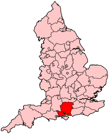
Location of Hampshire within England. | |
| County | Hampshire |
| Electorate | 67,696 (December 2010)[1] |
| Current constituency | |
| Created | 2010 |
| Member of parliament | Caroline Nokes (Conservative) |
| Number of members | One |
| Created from | Romsey |
| Overlaps | |
| European Parliament constituency | South East England |
Romsey and Southampton North is a constituency represented in the House of Commons of the UK Parliament since its 2010 creation by Caroline Nokes, a Conservative. For the purposes of election expenses and type of returning officer it is a county constituency.
History
Parliament accepted the Boundary Commission's Fifth Periodic Review of Westminster constituencies which created this constituency for the 2010 general election primarily as an extended Romsey constituency.
Boundaries
Romsey and Southampton North is formed from electoral wards:
- Bassett; and Swaythling in the City of Southampton:
- Abbey, Ampfield and Braishfield, Blackwater, Broughton and Stockbridge, Chilworth, Nursling and Rownhams, Cupernham, Dun Valley, Harewood, Kings Somborne and Michelmersh, North Baddesley, Over Wallop, Romsey Extra, Tadburn, Valley Park in Test Valley[2]
The area includes Stockbridge, which was a rotten borough constituency until the latter's abolition under the Great Reform Act of 1832.
Constituency profile
The constituency consists of two local government districts with similar characteristics: a working population whose income is close to the national average and lower than average reliance upon social housing.[3] At the end of 2012 the unemployment rate in the constituency stood as 1.5% of the population claiming jobseekers allowance, compared to the regional average of 2.4%.[4] The borough contributing to the bulk of the seat has a low 13.5% of its population without a car, 18.4% of the population without qualifications and a high 30.5% with level 4 qualifications or above. In terms of tenure 70.4% of homes are owned outright or on a mortgage as at the 2011 census across the Test Valley district.[5]
Members of Parliament
| Election | Member[6] | Party | |
|---|---|---|---|
| 2010 | Caroline Nokes | Conservative | |
Elections
Elections in the 2010s
| Party | Candidate | Votes | % | ± | |
|---|---|---|---|---|---|
| Conservative | Caroline Nokes | 26,285 | 54.4 | +4.6 | |
| Liberal Democrat | Ben Nicholls | 8,573 | 17.7 | -23.5 | |
| Labour | Darren Paffey | 5,749 | 11.9 | +5.5 | |
| UKIP | Sandra James | 5,511 | 11.4 | +8.8 | |
| Green | Ian Callaghan | 2,218 | 4.6 | n/a | |
| Majority | 17,712 | 36.6 | |||
| Turnout | 72.76 | ||||
| Conservative hold | Swing | +14.1 | |||
This constituency was contested for the first time at the 2010 general election.
| Party | Candidate | Votes | % | ± | |
|---|---|---|---|---|---|
| Conservative | Caroline Nokes | 24,345 | 49.7 | +6.6 | |
| Liberal Democrat | Sandra Gidley | 20,189 | 41.3 | −2.4 | |
| Labour | Aktar Beg | 3,116 | 6.4 | -4.6 | |
| UKIP | John Meropoulos | 1,289 | 2.6 | +0.3 | |
| Majority | 4,156 | 8.4 | |||
| Turnout | 48,939 | 72.6 | +6.2 | ||
| Conservative gain from Liberal Democrat | Swing | +4.5 | |||
See also
Notes and references
- Notes
- References
- ↑ "Electorate Figures - Boundary Commission for England". 2011 Electorate Figures. Boundary Commission for England. 4 March 2011. Retrieved 13 March 2011.
- ↑ 2010 post-revision map non-metropolitan areas and unitary authorities of England
- ↑ 2001 Census
- ↑ Unemployment claimants by constituency The Guardian
- ↑ 2011 census interactive maps
- ↑ Leigh Rayment's Historical List of MPs – Constituencies beginning with "R" (part 2)
- ↑ "Election Data 2015". Electoral Calculus. Archived from the original on 17 October 2015. Retrieved 17 October 2015.
- ↑ "Election Data 2010". Electoral Calculus. Archived from the original on 17 October 2015. Retrieved 17 October 2015.

