Route 36 (Iceland)
| |
|---|---|
| Þingvallavegur | |
 | |
| Major junctions | |
| Western end: | 1 Vesturlandsvegur |
| Southern end: | 35 Biskupstungnabraut |
| Highway system | |
| National Roads in Iceland | |
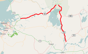
Þingvallavegur or Route 36 is a primary road in southern Iceland. The road forms the main route from Reykjavík to Thingvellir, as well as old Sogsvegar down with Thingvallavatn and Sog east connecting Thingvallasveit the Town and vicinity. The road is 68 km long, of which 33 km is from Vesturlandsvegur the service center at Thingvellir.
Starting from its junction with the Biskupstungnabraut (35) in Þrastarskógi the road runs north and forms a bypass of Ljósafossvirkjun and Steingrímsstöd. Further on the road reaches Gjábakkahellir and a crossroads with Lyngdal Heiðarvegur (365) and Þingvallavegi (361). From here the road runs around the north of Thingvellir where it connects with Uxahryggir (52) and (550).
Now the route is heading west towards Reykjavík, halfway along it meets the road Kjós Pass Road (48) in Háheiðinni. Earlier in the 20th century the road was considerably further south. The current layout now, however, the northernmost Mosfellsheiði set in clay Vogs water, but then down mosfellsdalur out Vesturlandsvegur above Mosfellsbæ. Finally the route ends on the Ring Road (1) just outside Reykjavík.
The road from the capital was not fully paved until shortly before the republic birthday in 1994, and part of Sogsveginum was still a gravel surface until 2000. More often than not has been done to repair the road when stórhátíðar at Thingvellir have been on the agenda.
