Rowień-Folwarki
| Rowień-Folwarki | |
|---|---|
| Żory District | |
|
Chapel in Rowień | |
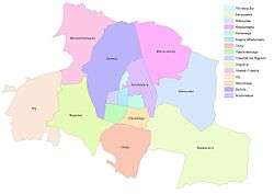
 Location of Rowień-Folwarki within Żory | |
| Coordinates: 50°04′02.204″N 18°39′13.338″E / 50.06727889°N 18.65370500°ECoordinates: 50°04′02.204″N 18°39′13.338″E / 50.06727889°N 18.65370500°E | |
| Country |
|
| Voivodeship | Silesian |
| County/City | Żory |
| Area | |
| • Total | 6.1884 km2 (2.3894 sq mi) |
| Population (2013) | |
| • Total | 1,927 |
| • Density | 310/km2 (810/sq mi) |
| Time zone | CET (UTC+1) |
| • Summer (DST) | CEST (UTC+2) |
| Area code(s) | (+48) 032 |
| Website | www.rowien-folwarki.zory.pl |
Rowień-Folwarki is a district in the north-west of Żory, Silesian Voivodeship, southern Poland. It has an area of 6.1884 km2 and in January, 2013 had 1,927 inhabitants.[1]
It encompasses two former settlements:
History
Rowień was first mentioned in a Latin document of Diocese of Wrocław called Liber fundationis episcopatus Vratislaviensis from around 1305 as item in Rovona decima solvitur more polonico et valet I) marcas.[2][3] Folwarki evolved later, but was tied with Rowień.
After World War I in the Upper Silesia plebiscite 374 out of 407 voters in Rowień voted in favour of joining Poland, against 33 opting for staying in Germany, whereas in Folwarki (Vorbriegen) it was 59 out of 73 against 14.[4]
In years 1945-1954 both villages were a part of gmina Boguszowice.
References
- ↑ "Dane statystyczne" (in Polish). rowien-folwarki.zory.pl. Retrieved 2015-05-14.
- ↑ Schulte, Wilhelm (1889). Codex Diplomaticus Silesiae T.14 Liber Fundationis Episcopatus Vratislaviensis (in German). Breslau.
- ↑ "Liber fundationis episcopatus Vratislaviensis" (in Latin). Retrieved 13 July 2014.
- ↑ "Results of the Upper Silesia plebiscite in Rybnik County" (in German). Retrieved 2015-05-03.