Rumoi River
| Rumoi River (Rumoi-gawa) | |
| 留萌川 | |
| River | |
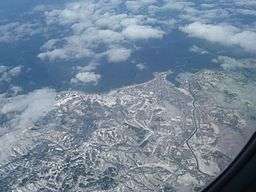
 Aerial view of the city of Rumoi, with the Rumoi River at right | |
| Country | Japan |
|---|---|
| State | Hokkaidō |
| Region | Rumoi |
| District | Rumoi |
| Source | Mount Poroshiri |
| - location | Rumoi, Hokkaidō, Japan |
| - elevation | 730.2 m (2,396 ft) |
| - coordinates | JP 43°57′46″N 141°50′10″E / 43.96278°N 141.83611°E |
| Mouth | Sea of Japan |
| - location | Rumoi, Hokkaidō, Japan |
| - elevation | 0 m (0 ft) |
| - coordinates | JP 43°57′22″N 141°38′33″E / 43.95611°N 141.64250°ECoordinates: JP 43°57′22″N 141°38′33″E / 43.95611°N 141.64250°E |
| Length | 44 km (27 mi) |
| Basin | 270 km2 (104 sq mi) |
| Discharge | |
| - average | 13.3 m3/s (470 cu ft/s) |
Rumoi River (留萌川 Rumoi-gawa) is a river in Hokkaidō, Japan. The Rumoi is 44 kilometres (27 mi) in length. It traces its source to Mount Poroshiri 731 metres (2,398 ft) in the Hidaka Mountain range, and flows across Rumoi Subprefecture in the west of Hokkaidō and empties into the Sea of Japan. The mouth of the Rumoi River is in the city of Rumoi.[1]
References
This article is issued from Wikipedia - version of the 6/23/2016. The text is available under the Creative Commons Attribution/Share Alike but additional terms may apply for the media files.