São Pedro da Água Branca
| São Pedro da Água Branca | |
|---|---|
| Municipality | |
| The Municipality of São Pedro da Água Branca | |
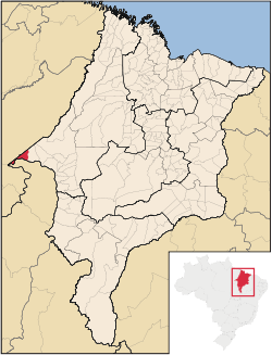
 Location of São Pedro da Água Branca | |
| Coordinates: 05°05′06″S 48°25′44″W / 5.08500°S 48.42889°WCoordinates: 05°05′06″S 48°25′44″W / 5.08500°S 48.42889°W | |
| Country |
|
| Region | Northeast |
| State |
|
| Founded | June 5, 1996 |
| Government | |
| • Mayor | Idelzio Gonçalves de Oliveira (PTB) |
| Area | |
| • Total | 720.492 km2 (278.184 sq mi) |
| Population (2008) | |
| • Total | 11,439 |
| • Density | 15.5/km2 (40/sq mi) |
| [1] | |
| Time zone | UTC-3 (UTC-3) |
| HDI (2000) | 0.588 – medium[2] |
São Pedro da Água Branca is the westernmost municipality in the Brazilian state of Maranhão, bordering both Pará and Tocantins states.
References
This article is issued from Wikipedia - version of the 5/10/2016. The text is available under the Creative Commons Attribution/Share Alike but additional terms may apply for the media files.