Sanuki Province

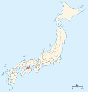
Sanuki Province (讃岐国 Sanuki-no kuni) was an old province of Japan on the island of Shikoku, with the same boundaries as modern Kagawa Prefecture.[1] It was sometimes called Sanshū (讃州) .
It faced the Inland Sea and bordered on Awa and Iyo Provinces. Across Naruto strait it bordered Awaji Province too. Administratively it was included as a part of Nankaidō. It was settled in the 7th century and originally consisted of the northeastern part of Shikoku and Awaku Islands on the Inland Sea.
History
Sanuki's ancient capital is believed to have been near modern Sakaide, but has not been discovered. Takamatsu developed as the main seat of the province in the Middle Ages.
In the Classical Period, Sanuki was famous for its associations with the Buddhist monk, Kūkai, as both his birthplace and early upbringing. Later, the famed poet Sugawara no Michizane served as governor of the province from 886 to 890 under the Ritsuryō Codes.
In the Sengoku Period, Sanuki was ruled by the Miyoshi clan. The Miyoshi were invaded by Chōsokabe clan in Tosa Province and lost Sanuki province. Finally Chōsokabe lost a battle against Toyotomi Hideyoshi and Sanuki was given to his men.
In the Edo Period, Sanuki was divided into five; three han in Takamatsu, Marugame, Tadotsu, the Shōgun's direct holding and a part of Tsuyama han whose mainland was on Honshū. Naoshima and Shōdoshima was separated from Bizen Province and merged into Sanuki Province.
Historical districts
- Kagawa Prefecture
- Aya District (阿野郡) - merged with Uta District to become Ayauta District (綾歌郡) on March 16, 1899
- Kagawa District (香川郡)
- Miki District (三木郡) - merged with Yamada District to become Kita District (木田郡) on March 16, 1899
- Mino District (三野郡) - merged with Toyota District to become Mitoyo District (三豊郡) on March 16, 1899
- Naka District (那珂郡) - merged with Tado District to become Nakatado District (仲多度郡) on March 16, 1899
- Ōuchi District (大内郡) - merged with Sangawa District to become Ōkawa District (大川郡) on March 16, 1899
- Sangawa District (寒川郡) - merged with Ōuchi District to become Ōkawa District on March 16, 1899
- Shōzu District (小豆郡)
- Tado District (多度郡) - merged with Naka District to become Nakatado District on March 16, 1899
- Toyota District (豊田郡) - merged with Mino District to become Mitoyo District on March 16, 1899
- Uta District (鵜足郡) - merged with Ata District to become Ayauta District on March 16, 1899
- Yamada District (山田郡) - merged with Miki District to become Kita District on March 16, 1899
See also
- Sanuki udon - Local type of Udon
- Kamatamare Sanuki - Local football club based in Takamatsu
Notes
- ↑ Nussbaum, Louis-Frédéric. (2005). "Sanuki" in Japan Encyclopedia, p. 823, p. 823, at Google Books.
References
- Nussbaum, Louis-Frédéric and Käthe Roth. (2005). Japan encyclopedia. Cambridge: Harvard University Press. ISBN 978-0-674-01753-5; OCLC 58053128
External links
![]() Media related to Sanuki Province at Wikimedia Commons
Media related to Sanuki Province at Wikimedia Commons