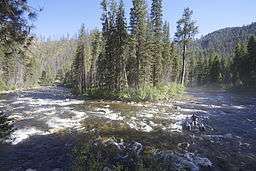
Secesh River
| Secesh River | |
 | |
| Country | United States |
|---|---|
| State | Idaho |
| Tributaries | |
| - left | Lake Creek (Idaho), Piah Creek, Warm Springs Creek (Idaho) |
| - right | Summit Creek, Loon Creek, Lick Creek (Idaho) |
| Source | Confluence of Lake Creek and Summit Creek |
| - location | Burgdorf, Idaho County |
| - elevation | 6,099 ft (1,859 m) |
| - coordinates | 45°16′33″N 115°55′07″W / 45.27583°N 115.91861°W [1] |
| Mouth | South Fork Salmon River |
| - location | Browns Camp, Valley County |
| - elevation | 3,629 ft (1,106 m) |
| - coordinates | 45°01′30″N 115°42′27″W / 45.02500°N 115.70750°WCoordinates: 45°01′30″N 115°42′27″W / 45.02500°N 115.70750°W [1] |
| Length | 27 mi (43 km) [2] |
| Discharge | for Secesh Meadows |
| - average | 194 cu ft/s (5 m3/s) [3] |
| - max | 2,500 cu ft/s (71 m3/s) |
| - min | 33 cu ft/s (1 m3/s) |
The Secesh River is a 27-mile (43 km)[2] tributary of the South Fork Salmon River in Idaho and Valley Counties, Idaho in the United States. The river begins at the confluence of Lake Creek and Summit Creek near the unincorporated community of Burgdorf and flows generally southeast, through Secesh Meadows and a series of canyons, emptying into the South Fork near Browns Camp.[4]
The river drains a remote wilderness watershed in the Salmon River Mountains. Situated in the Payette National Forest, it is a popular destination for whitewater boating, and its confluence with the South Fork also marks the beginning of the South Fork's main whitewater run.
See also
References
- 1 2 "Secesh River". Geographic Names Information System. United States Geological Survey. 1979-06-21. Retrieved 2013-12-16.
- 1 2 "USGS National Atlas Streamer". United States Geological Survey. Retrieved 2013-12-16.
- ↑ "USGS Gage #13313500 on the Secesh River near Burgdorf, ID". National Water Information System. United States Geological Survey. 1943–1952. Retrieved 2013-12-16.
- ↑ USGS Topo Maps for United States (Map). Cartography by United States Geological Survey. ACME Mapper. Retrieved 2013-12-16.
This article is issued from Wikipedia - version of the 9/11/2016. The text is available under the Creative Commons Attribution/Share Alike but additional terms may apply for the media files.