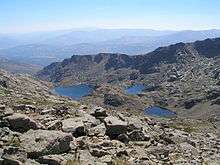
Sierra de Béjar
| Sierra de Béjar | |
| Sub-Range | |
| Panorama | |
| Country | Spain |
|---|---|
| Region | Iberian Peninsula |
| Part of | Sistema Central |
| Highest point | Canchal de la Ceja |
| - elevation | 2,428 m (7,966 ft) |
| - coordinates | ES 48°18′22″N 5°43′17″W / 48.30611°N 5.72139°W |
| Geology | Granite, Granodiorite and Migmatite[1] |
The Sierra de Béjar is a mountain range near the centre of the Iberian Peninsula.
Geography

Trampal lakes
The highest point of the range is Canchal de la Ceja, at 2428 metres.[1]
Some geographers consider Sierra de Béjar as the westernmost part of sierra de Gredos.[2]
Bibliography
- Rosa; Pedraza; Sanz; Domínguez-Villar; Willenbring (2010). El glaciar de Cuerpo de Hombre (Sierra de Béjar, Sistema Central Español) durante la deglaciación: génesis primaria del till supraglaciar de Los Hermanitos. Universidad de Huelva.
- Rosa; Villa; de la Pedraza; Domínguez-Villar; Willenbring (2011). Reconstrucción y cronología del glaciar de meseta de la Sierra de Béjar (Sistema Central Español) durante el máximo glaciar (PDF). Boletín de la Real Sociedad Española de Historia Natural. Sección geológica n.105. pp. 125–135. ISSN 0583-7510.
- Juan José Sanz Donaire (1986). El corredor de Béjar. 2. Consejo Superior de Investigaciones Científicas. ISBN 9788400062118.
See also
References
This article is issued from Wikipedia - version of the 10/25/2016. The text is available under the Creative Commons Attribution/Share Alike but additional terms may apply for the media files.