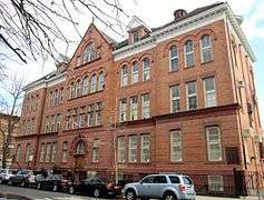
South Slope, Brooklyn
Coordinates: 40°39′47″N 73°59′24″W / 40.663°N 73.990°W

The South Slope, originally South Park Slope, is a neighborhood in Brooklyn, New York City, which is located between Sunset Park and Park Slope. Because there are no official borders to neighborhoods in New York City, definitions of the boundaries of the South Slope can differ significantly. The New York Times real estate listings, for instance, use 9th Street as the northern border, the Prospect Expressway as the southern border, with Fourth Avenue the boundary of the west and Prospect Park West and 8th Avenue to the east.[1] Other definitions use 15th Street on the north and 24th Street to the south.
While the name "south Slope" has been used for many years, the area was officially designated "South Park Slope" when it was rezoned by the New York City Department of City Planning in 2005.[2] It is primarily made up of pre-war row houses, although there has been a spate of new, non-contextual construction in recent years predominately in the inner blocks with higher density development along 4th Avenue due to the 2005 R8A zoning designation.
The South Slope is a part of Brooklyn Community Board 7 along with Greenwood Heights, Windsor Terrace and Sunset Park.
References
Notes
- ↑ New York Times Real Estate Listings Accessed: February 27, 2013
- ↑ "South Park Slope". New York City Department of City Planning. Retrieved 2009-03-01.
External links
 Media related to South Slope, Brooklyn at Wikimedia Commons
- South Slope News
