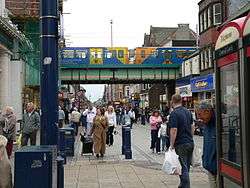
South Shields Metro station
| South Shields | |
|---|---|
| Tyne and Wear Metro | |
|
| |
|
The train in this view shows cars with two different liveries. The one on the right is the standard Blue livery and the one on the left is carrying a Disability Discrimination Act compliant livery. | |
| Location | |
| Place | South Shields |
| Local authority | South Tyneside |
| Fare zone information | |
| Network One zone | 3 |
| Metro zone | C |
| Original (1979) zone | 38 |
| Station code | SSS |
| Operations | |
| Platforms | 1 |
| History | |
| Opened | 1984-03-24 |
| List of stations | |
South Shields Metro station is the main Tyne and Wear Metro station for South Shields, England. In 2008-9 the station was used by over 1 million passengers.[1] The station is located on a bridge above King Street, the main shopping street in South Shields Town Centre. The Metro station is located about 200 metres down the line from the former South Shields railway station, which it replaced. The station includes a newsagent and a sandwich bar (the latter formerly a Nexus Travel Centre) at ground level.
The station can be accessed via the main concourse by either lift or stairs from King Street or Keppel Street Bus Station. The station can also be accessed via the Mile End Road concourse (on the site of the BR station) by ramp.
The original two-platform railway station closed on 1 June 1981, when the line was closed for conversion to Metro standards. However, the Grade II-listed station building (but not the overall roof or any other part of the platform area) survived for many years, housing a newsagent and a barber (and still retaining a BR corporate-style "Barber" sign), but has since been demolished.
The Metro line continues beyond the station and through the site of the BR station to some engineering sidings.
The new Metro station was opened on 24 March 1984 and completed the initial Tyne and Wear Metro system. It was originally the terminus of the Green line (from Bank Foot and later Airport), but is now the terminus of the Yellow line.
In June 2015, plans were unveiled for a new transport interchange to be built, featuring a new Metro station and enclosed bus station. This development would replace the existing Metro station, and the adjacent Keppel Street Bus Station.[2]
Notes
- ↑ NEXUS Business Intelligence Report. http://www.nexus.org.uk/wps/wcm/resources/file/eba01f018731343/Business%20Intelligence%20Annual%20Report%20200809.pdf
- ↑ "Nexus". Nexus. Retrieved 2015-09-15.
External links
| Wikimedia Commons has media related to South Shields Metro station. |
- Train times and station information for South Shields Metro station from Nexus
Coordinates: 54°59′55″N 1°26′01″W / 54.9985°N 1.4335°W
| Preceding station | Tyne and Wear Metro | Following station | ||
|---|---|---|---|---|
towards St James via the Coast | Yellow line | Terminus |
