Saint Anne's Hill Historic District
|
Saint Anne's Hill Historic District | |
|
A church in the district | |
  | |
| Location | Roughly bounded by Fourth, McClure, Josie, and High and Dutoit Sts., Dayton, Ohio |
|---|---|
| Coordinates | 39°45′24″N 84°10′23″W / 39.75667°N 84.17306°WCoordinates: 39°45′24″N 84°10′23″W / 39.75667°N 84.17306°W |
| Built | 1860 |
| Architect | Unknown |
| Architectural style | Second Empire, Queen Anne, Romanesque |
| NRHP Reference # | 86001214 [1] |
| Added to NRHP | June 05, 1986 |

Saint Anne's Hill Historic District is part of the Historic Inner East neighborhood in Dayton, Ohio, United States. St. Anne's Hill constitutes an excellent grouping of both vernacular and high style Victorian residences which date roughly from 1860 to the early 20th century. Some structures, such as the Bossler Mansion in the Second Empire, style, are the best of their style found in the city. The neighborhood is also significant for its German heritage.
Past and Present

Bomberger Park and Stivers School for the Arts.
Historic District
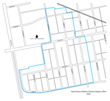
In 1986, St. Anne's Hill was registered on the National Register of Historic Places, bounded by Fourth, McClure, Josie, and High and Dutoit Sts., and Downtown Dayton (No. 86001214).[2] City of Dayton Ordinance #24688.[3]
Architecture
The architecture of St. Anne's Hill Historic District includes examples of Second Empire, Romanesque and Queen Anne.
Parks
In addition to bordering the Bomberger city park which contains Tennis & Basketball courts, a baseball diamond, soccer field and playground; there are several parks inside the district including Fred's Park, Alice's Park, Terry Street Park, and Victorian Park.
References
- ↑ National Park Service (2008-04-15). "National Register Information System". National Register of Historic Places. National Park Service.
- ↑ "OHIO - Montgomery County - Historic Districts". Retrieved 28 August 2006.
- ↑ "City of Dayton - Historic District Map" (PDF). Retrieved 5 October 2013.
External links
- St. Anne's Hill Historic District
- Preservation Dayton
- St. Anne's Hill on Dayton MostMetro
- City of Dayton's Official Website


