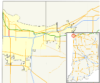
Indiana State Road 152
| ||||
|---|---|---|---|---|
| Indianapolis Boulevard | ||||
 | ||||
| Route information | ||||
| Maintained by INDOT | ||||
| Length: | 2.487 mi[1] (4.002 km) | |||
| Existed: | 1938 – present | |||
| Major junctions | ||||
| South end: |
| |||
| North end: |
| |||
| Location | ||||
| Counties: | Lake | |||
| Highway system | ||||
| ||||
State Road 152 in the U.S. State of Indiana is a short connector highway in northwest Indiana.
Route description
SR 152 begins at an interchange with I-80/I-94/US 6/US 41 (Borman Expressway) in Hammond. It travels north to an intersection with US 20 (Michigan Street), also in Hammond. This is a distance of 2.47 miles (3.98 km). For its entire length, SR 152 is known as Indianapolis Boulevard.
History
SR 152 was once part of US 152 until that highway's decommissioning in 1938. The rest of US 152 is now US 52, US 231, and US 41.
Major intersections
The entire route is in Hammond, Lake County.
| mi[1] | km | Destinations | Notes | ||
|---|---|---|---|---|---|
| 0.000 | 0.000 | Southern terminus of SR 152; route continues south as US 41 | |||
| 2.487 | 4.002 | Northern terminus of SR 152; route continues north as US 20 | |||
| 1.000 mi = 1.609 km; 1.000 km = 0.621 mi | |||||
References
- 1 2 Indiana Department of Transportation (July 2015). Reference Post Book (PDF). Indianapolis: Indiana Department of Transportation. Retrieved September 23, 2016.
This article is issued from Wikipedia - version of the 9/23/2016. The text is available under the Creative Commons Attribution/Share Alike but additional terms may apply for the media files.
