Stefansson Island
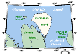
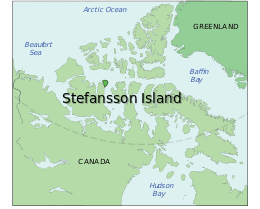
 Stefansson Island and surrounding area | |
 | |
| Geography | |
|---|---|
| Location | Viscount Melville Sound |
| Coordinates | 73°30′N 105°30′W / 73.500°N 105.500°WCoordinates: 73°30′N 105°30′W / 73.500°N 105.500°W |
| Archipelago | Canadian Arctic Archipelago |
| Area | 4,463 km2 (1,723 sq mi) |
| Highest elevation | 267 m (876 ft) |
| Highest point | unnamed |
| Administration | |
| Nunavut | Nunavut |
| Region | Kitikmeot |
| Demographics | |
| Population | 0 |
Stefansson Island is an uninhabited island in the Canadian Arctic Archipelago in the Kitikmeot Region of Nunavut, Canada. It has a total area of 4,463 km2 (1,723 sq mi), making it the 128th largest island in the world, and Canada's 27th largest island. The island is located in Viscount Melville Sound, with M'Clintock Channel to the east. It lies just off Victoria Island's Storkerson Peninsula, separated by the Goldsmith Channel. Stefansson Island's highest mount is 267 m (876 ft).[1]
The first European sighting of the island was in 1917 by Storker T. Storkerson who was travelling with Canadian explorer Vilhjalmur Stefansson (1879-1962), for whom the island was named.[2]
References
- ↑ The Atlas of Canada: Stefansson Island, Nunavut, scale 1:100000 or larger
- ↑ Mills, William James (2003). Exploring polar frontiers: a historical encyclopedia. Santa Barbara: ABC-CLIO.
Further reading
- Fyles, J. G. Surficial Geology of Victoria and Stefansson Islands, District of Franklin. Ottawa: Roger Duhamel, Queen's Printr, 1963.
This article is issued from Wikipedia - version of the 11/17/2016. The text is available under the Creative Commons Attribution/Share Alike but additional terms may apply for the media files.