Sturgeon Bay Ship Canal

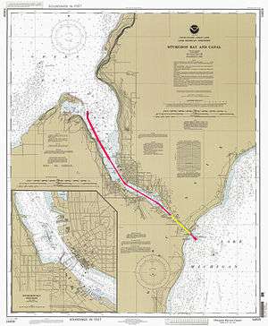
The Sturgeon Bay Ship Canal is a shipping canal connecting Sturgeon Bay on Green Bay with Lake Michigan, across the Door Peninsula, at the city of Sturgeon Bay, Wisconsin, United States.[1][2]


The canal is approximately seven miles in length, and consists of two parts: a dredged portion of Sturgeon Bay, and a 1.3-mile canal dug through the eastern side of the Door Peninsula. This shorter portion was dug by a private group headed by then-president of Chicago and North Western Railway, William B. Ogden, between July 8, 1872 and the late fall of 1881. Although smaller craft began using the canal in 1880, it was not open for large-scale watercraft until 1890.
The cost of making the 1.3 mile cut up to 1881 was $291,461.69.
In 1893, the Ogden private investors group sold all interest in the canal to the United States government. Since that time, the canal has been maintained by the U.S. Army Corps of Engineers.
The original canal was 7,400 feet (2.3 km) long, 100 feet (30 m) wide, and 6 feet (1.8 m) deep. As of June 1997 the canal was 7 miles (11 km) long, 125 feet (38 m) wide, and 16 1⁄2 to 21 1⁄2 feet (5 to 6 1⁄2 m) deep. A jetty extends into Lake Michigan 1,350 feet (410 m) and 800 feet (240 m) wide at the mouth.
Several famous lighthouses mark the course of the canal, including the Sturgeon Bay Canal Lighthouse at the eastern entrance on the northern side of the canal (approximately 230 feet from Lake Michigan) next to the Coast Guard Station Sturgeon Bay; the Sturgeon Bay Canal North Pierhead Light on the Lake Michigan coastline; and the Sherwood Point Lighthouse in Idlewild, on the far western end, on the southern shore of the outer edge of Sturgeon Bay.
Notes
External links
- Sturgeon Bay Canal North Pierhead Light page
- Sturgeon Bay Canal Light page
- Sturgeon Bay Ship Canal page at AmericanCanals.org
Coordinates: 44°48′02″N 87°19′19″W / 44.80056°N 87.32194°W