Tamparuli
| Tamparuli | |
|---|---|
| Other transcription(s) | |
| • Simplified Chinese | 担波罗利 |
| • Traditional Chinese | 擔波羅利 |
|
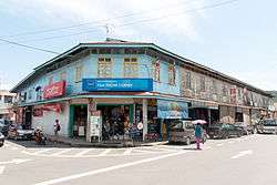
Colonial-era shoplots in downtown Tamparuli | |
 Tamparuli | |
| Coordinates: 6°8′0″N 116°16′0″E / 6.13333°N 116.26667°E | |
| Country |
|
| State |
|
| Government | |
| • Assistant District Officer | Celestinus Lawanding |
| Time zone | MST (UTC+8) |
| Postcode | 8925X |
| Area code(s) | 088 |

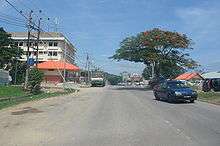
Tamparuli is a small town and a sub-district of Tuaran on the west coast of Sabah, Malaysia. It is populated mainly by native Dusuns, while a sizeable Chinese community (of whom most are Hakkas) runs most of the shops in the town proper. As with many other small towns in Sabah and indeed Malaysia as a whole, the town itself consists of both newer concrete shoplots as well as old wooden ones, which are particularly prone to destruction by fire as evidenced in the destruction of one of the wooden shoplots in recent years.
The most famous landmark in Tamparuli is a long hanging bridge which is immortalised in the song Jambatan Tamparuli, a popular Kadazandusun song. Another bridge, built for motor traffic, spans the river far below the hanging bridge and is frequently flooded during heavy rain.
Tamparuli is located just off the Kota Kinabalu - Sandakan road, making it a popular stop for a snack or meal for travellers taking this route from the direction of Kota Kinabalu. The town is also a convenient stop en route to the town of Kiulu, a popular whitewater rafting destination for domestic and foreign tourists alike.
Tourist Attraction
The 'Upside Down House' or Rumah Terbalik is a popular tourist attraction located in the town. It is the only structure of such type known to exist in Malaysia so far and a guided tour is available for visitors at daytime.[1]
References
- ↑ "Rumah Terbalik @ Tamparuli, Sabah". Steffie Chan's Blog. Retrieved 29 May 2013.
|first1=missing|last1=in Authors list (help)
Coordinates: 6°08′N 116°16′E / 6.133°N 116.267°E
